A reminder about EarthCache
ATTENTION, there is no container to look for or logbook to fill in. All you have to do is go to the observation site and complete the validation conditions below.
As the aim of an EarthCache is to put a geology lesson into practice by making observations in the field, we recommend that you read the description to help you answer the questions.
Questions to validate the geological cache
- Question 0 : Take a photo of yourself or your nickname with the Coupée in the background.
You can either send us this photo with your answers or add it to your log.
Here we are a few dozen metres before the Coupée, between two cliffs that provide a cross-sectional view of the Sark geological formation at this point (photo WP1).
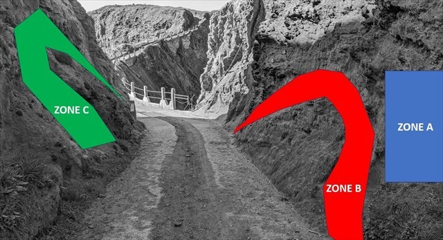
Let's start by looking at the cliff on the right-hand side of the path.
- Question 1 : The rock beneath the blue zone A, although weathered, has a characteristic that makes it possible to determine the nature of the bedrock in this area between the two main Sark rocks.
What is this feature, and what rock is the bedrock at WP1 made of?
- Question 2 : A dyke can be seen below the red zone B. Describe the characteristics of the rock forming this dyke and deduce its geological nature.
Turn round and look at the cliff on the left-hand side at green zone C.
- Question 3 : By describing the cliff and saying what happens when you rub the rock with your hands, can you tell whether the rock is healthy or weathered?
- Question 4 : What is the general colour of the cliff and what mineral is responsible for it?
You can log in without waiting for our confirmation, but you must send us the answers at the same time.
by e-mail via our profile (
fafahakkai), or via the geocaching.com messaging system (Message Center).
If there are any problems with your answers, we will let you know.
Logs recorded without any response and photo will be deleted.
What does this mean in theory?
Sark is a small island of 5 km2 located a few kilometres to the east of Guernsey and is made up of two distinct parts commonly known as Little and Great Sercq, linked together by a very narrow isthmus, "la Coupée".
This particular topography is linked to its dual geological structure.
► Sark, a geological island with two faces
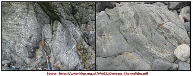
~ Great Sark, the metamorphic face of the island
Almost all of Great Sark is formed from a metamorphic basement of paragneiss (gneiss whose protolith is a sedimentary rock) dating from the Precambrian (600 Ma).
The sedimentary formations underwent significant increases in temperature and pressure, transforming the protolith into a foliated metamorphic rock.
Its strata form alternating light bands of sandstone origin and dark bands of clay origin.
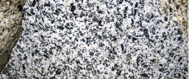
~ Little Sark, the island's plutonic face
Little Sark is formed from a granodiorite pluton, a non-bedded rock of magmatic origin.
This crystalline rock has a high proportion of black mica (biotite), making it darker than normal granite, hence the term granodiorite.
Unlike gneiss, granodiorite is a massive rock with no stratification.
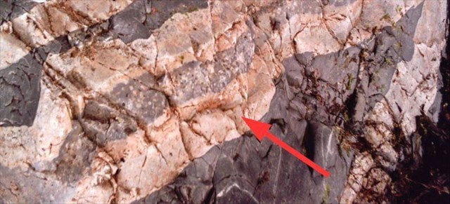
► Dykes and intrusion
Over geological time, these two poorly ductile basement rocks fractured, creating fissures where magmatic fluids could penetrate and then crystallise into veins called dyke.
Sark dykes are of two types, depending on the chemical composition of the original magma:
~ If the magma is acidic (rich in silica), it gives Felsite, a light-coloured rock composed mainly of quartz and felspar. This is known as leucocrate rock ("leuco" = light).
The rock takes on a pinkish hue due to the presence of iron in the form of ferric ion (Fe3+).
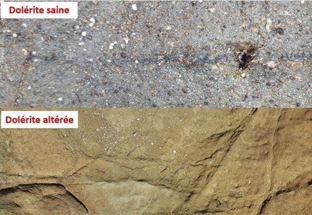
If the magma is basic, this gives dolerite, a dark rock composed of ferromagnesian minerals (pyroxene, biotite, etc.). This is known as melanocortic rock ("melano" = dark).
Dolerite takes on a grey-black to rusty-brown colour depending on the degree of alteration.
► Kaolinisation, an alteration process in the Sark basement
The rocks of the Sark basement are exposed to natural elements at the surface (rain, wind, etc.), leading to chemical alteration of the minerals.
At the surface, the rock becomes increasingly fragile as a result of the alteration of some of its minerals. It becomes very brittle, and the simple act of rubbing it will cause elements to fall off.
The original minerals undergo chemical transformations. For example, feldspars are transformed by hydrolysis into kaolinite, a loose formation with a very fine texture (clay) that is rather soft to the touch.
Generally white, this clay can take on a pink colour if oxidised iron minerals (Fe3+) are present, giving a red colour to the soil.
► Bibliographical sources