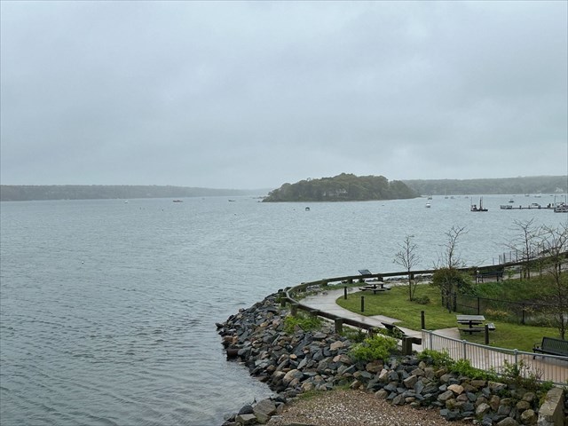
Martha's Vineyard is located south of Cape Cod in Massachusetts and is renowned for its scenic beauty, charming towns, and rich history. Covering approximately 100 square miles, the island is a popular summer destination, known for its pristine beaches, quaint cottages, and vibrant cultural scene. The listed coordinates will bring you to a spot overlooking Lagoon Pond where you say see remnants of the islands glacial past, and learn about the different geologic forces interacted with each other.
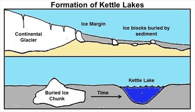
Lagoon Pond was formed roughly 10,000 years ago during glacial times when buried ice blocks melted. The formation of the pond is very similar to how a kettle pond is formed. As the glaciers retreated, large chunks of ice are left behind, that can be either partially or fully buried in the sediment that was carried by the glacier. When the ice blocks melt, they leave behind depressions in the landscape where they were once located which are known as kettles, which can fill with either precipitation, groundwater, or surface runoff (at which point they become kettle ponds or kettle lakes). They are usually circular or irregular in shape, and vary in size greatly. What makes Lagoon Pond unique, and the process by which it formed slightly different is that that it formed by several ice blocks that had melted. Also, kettle ponds (or lakes) often have no inlet or outlets, while as you can see here, there is an inlet/outlet into Lagoon Pond (we will go more into the why later). If you look around, you will see cliffs and steep slopes along the shoreline of the pond. These also have a unique geologic story to tell, they were not formed by erosion, but rather by the collapse of glacial sediment into a depression left by melted ice. When the ice melted, Martha's Vineyard was merely a low hill on the plain extending south from Cape Cod. Within a few thousand years most of the ice cap had melted and the sea began to flood the glacial landscape of southern New England. Lagoon Pond was separated from Vineyard Sound by a barrier beach called Long Beach. It was probably formed a few thousand years ago by wave driven sand from the exposed cliffs at East Chop (this process is essentially longshore sediment transport, which we will learn more about later).

Above is a map showing what this part of the island looked like in 1847. The red circle shows the area where you are currently standing. There was a barrier beach that extended across the mouth of Lagoon Pond up to what is now the five way intersection roughly 1/2 mile southwest of here. There was a natural inlet that permitted passage between the pond and Vineyard Haven Harbor (then known as Holmes Hole Harbor).

Longshore sediment transport is defined as being the movement of sediment along a coastline due to wave action. It occurs when waves approach the shore at an angle, which generates a current parallel to the shoreline that is known as the longshore current. The interplay of the swash, which is the uprush of water onto the beach, and the backwash, the water returning to the ocean, results in a zigzag motion that transports sediment such as sand, gravel, and silt along the coast. This sediment movement helps shape the coastal landscape. One important thing to remember is that it is a dynamic process, which means that things are constantly changing due to different environmental factors such as wave energy, sediment supply, and coastal topography.
Storms can significantly influence the coastal landscape through intense wave action and higher water levels. For example, during severe storms, high-energy waves and storm surges can break through barrier beaches, creating new inlets, as with the case of this inlet near where you are standing, which was opened by the Great September Gale of 1815. Also, storms can erode and deposit large amounts of sediment, which would lead to the formation or shifting of channels. Another impact of storms is that they can lead to erosion of beaches (while some areas would see sediment deposition).
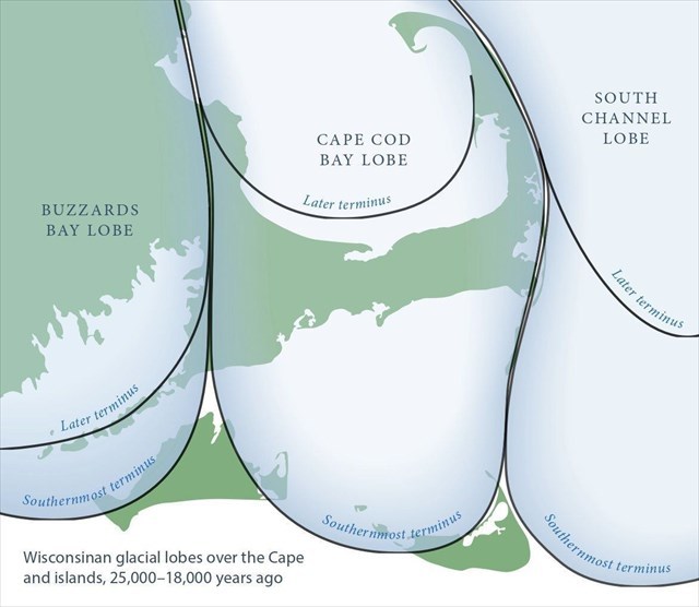
One other topic that is worth mentioning has to do with the shape of the island. Looking on a map of Marthas Vineyard, you may have been curious about the islands unique shape. Approximately 10,000 years ago during the Wisconsinan glaciation, multiple glacial lobes (which are extensions/protrusions of large ice sheet) advanced into the northeastern United States, significantly shaping the landscape. Specifically, the Buzzards Bay Lobe and the Cape Cod Bay Lobe played a crucial role in forming Martha's Vineyard. The Buzzards Bay Lobe, moving southward, deposited large amounts of glacial till, which formed the island's western moraines and outwash plains. Simultaneously, the Cape Cod Bay Lobe advanced from the northeast, contributing additional sediment and shaping the eastern part of the island. The interaction of these two lobes resulted in the distinctive geological features and irregular coastline of Martha's Vineyard, as seen by the image above.
Logging Requirements:
- At the time of your visit, is water entering or leaving Lagoon Pond? Do you see any other locations where water enters or leaves Lagoon Pond? Next, looking around, do you see any signs of cliffs or bluffs actively eroding into the pond (those would be evident by areas where it appears material has been eroding downhill into the pond)?
- Is there any evidence of longshore sediment transport? Do you think dredging will required in order to keep this channel open? Based on what you see, how likely or unlikely do you think it is that the location of this inlet/outlet might change in the future?
- Upload a photo taken at the overlook. You don't have to be in the photo, though it is strongly encouraged.