|

🇷🇴 Acest earthcache vă va arăta meander în centrul orașului Arad. Bucurați-vă!
🇬🇧 This earthcache will show you the meander in the city centre of Arad. Enjoy!
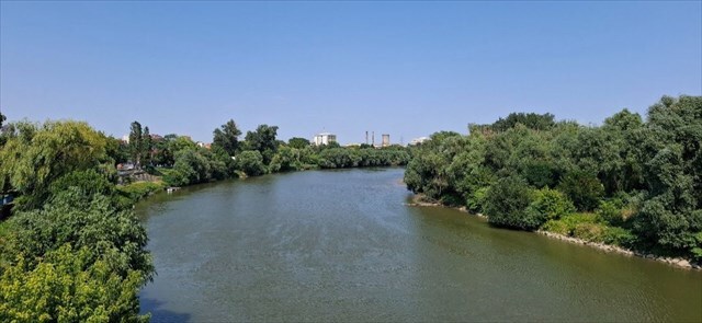
Meandering
🇷🇴 Serpuirile sunt folosite pentru a caracteriza anumite tipuri de râuri pe baza designului lor. Există trei tipuri de afluenți: împletite, drepte și curbate sau serpentine. În râurile care curg prin câmpia inundabilă, șerpuirea este de obicei mai ușor de format când panta este mică. Sedimentul este de obicei depus în denivelare în zig-zag și apoi se deplasează de acolo către țărm. În adâncituri, eroziunea domină și este clar cum umplutura se retrage din cauza forței centrifuge. Când înaintarea umpluturii în zona convexă este combinată cu retragerea zonei concave, cursul râului începe să migreze și apar șerpuiri. Pe măsură ce râul se deplasează pe suprafața poroasă, permeabilă, marginile pasajului natural prin care râul continuă să curgă sunt erodate. Pe măsură ce se uzează, capătă o formă concavă caracteristică, care creează o curbă.
🇬🇧 Meandering are used to characterize specific types of rivers based on their design. There are three types of tributaries: braided, straight and curved or serpentine. In the rivers that flow through the floodplain, meandering are usually easier to form when the slope is small. The sediment is usually deposited in the bump in a zigzag fashion and then moves from there to the shore. In the recesses, erosion dominates, and it is clear how the filling retreats due to the centrifugal force. When the advance of the fill in the convex zone is combined with the retreat of the concave zone, the river course begins to migrate and meandering occur. As the river moves over the porous, permeable surface, the edges of the natural passage through which the river continues to flow are eroded. As it wears out, it takes on a characteristic concave shape, which creates a curve.
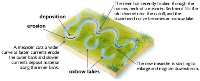
River bank types 🇷🇴 Râurile meandrate alternează între locuri cu curgere rapidă și lentă. Se formează bazine adânci și pereți perpendiculari pe malurile unde apa îndepărtează materialul. Pe malul opus, unde râul curge mai lent, materialul se depune și se formează diguri. Dinamica curgerii nu s-a manifestat doar prin schimbările axei sale verticale, ci și pe axa orizontală, prin deplasarea laterală a curentului. Pe măsură ce canalul își modifica cursul și meandrele se lățeau, bușteni mai mari și mai mici sau chiar copaci întregi ajungeau în râuri, formând obstacole în curgere și direcționând forța curentului spre malul opus, servind adesea drept bază pentru formarea unei noi meandre. Malul aluvionar și malul riparian sunt două tipuri distincte de maluri care apar în apropierea meandrelor. Acestea joacă un rol esențial în procesul de sedimentare al râurilor. Malul aluvionar, cunoscut și sub numele de terasă aluvionară, se formează în principal prin depunerea sedimentelor pe malul unui curs de apă. Aceste sedimente sunt transportate de curgerea apei și se depun pe mal atunci când viteza curgerii scade. Acest tip de mal este, de obicei, larg și cu o pantă graduală. Este frecvent în locurile unde viteza curentului scade și sedimentul are tendința de a se depune. În schimb, malul abrupt este un mal supus unei eroziuni severe din cauza curgerii apei, în special într-o meandră. Aceste maluri sunt de obicei abrupte și adesea au o suprafață stâncoasă sau cu o pantă abruptă. Apa influențează puternic forma acestui mal, iar eroziunea ulterioară transportă material de pe malul riparian în apă, unde se va depune ulterior pe malul aluvionar. 🇬🇧 Meandering rivers alternate between places with fast and slow flow. Deep pools and perpendicular walls are formed on surging banks where water removes material. On the opposite bank, as the river flows more slowly, material is deposited and embankments form. The dynamics of the flow were not only manifested by changes in its vertical axis, but also in its horizontal axis, with the flow shifting sideways. As the channel changed course and meanders widened, larger and smaller logs or even whole trees entered the rivers, forming obstacles in the flows and directing the force of the current to the opposite bank, often providing the basis for the formation of a new meander. A riprap bank and a rip-rap bank are two distinct types of banks that occur near meanders. They play an essential role in the process of river sedimentation. The alluvial bank, also referred to as the alluvial terrace, is formed primarily by the deposition of sediment on the bank of a watercourse. These sediments are carried by the flow of water and deposited on the bank when the flow velocity decreases. This type of bank is usually wide and has a gradual slope. It is common in places where flow velocity decreases and sediment tends to be deposited. Conversely, a surge bank is a bank that is subject to severe erosion by water flow, especially in a meander. These banks are typically steep and often have a rocky or steeply sloping surface. Water strongly influences the shape of this bank, and subsequent erosion carries material from the riparian bank into the water where it subsequently sediments on the alluvial bank. 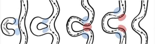
🇷🇴 "Buldum" olarak oturum açmak için lütfen bu soruların yanıtlarını profilim aracılığıyla bana gönderin:
1) Descrieți cu propriile cuvinte procesul de șerpuire. 2) Pe baza examinării tale în teren, de ce crezi că pietricelele de jos sunt rotunjite? 3) Mergeți prin albia secată a pârâului și determinați adâncimea acestuia.
4) Adăugați în jurnal o fotografie cu dvs. sau cu GPS-ul dvs. cu meandre pe coordonate.
🇬🇧 For log as "found it" please send me answers for those questions via my profile:
1) Describe in your own words the meandering process. 2) Based on your examination in terrain, in which direction will the river streamline most likely develop?
3) Explain the types of meanders. Which type do we encounter here in Arad? Justify your statement.
4) Add a photo of yourself or your GPS with meander on the coordinates to the log.
🇷🇴 După trimiterea răspunsurilor, vă rog să înregistrați imediat jurnalul, mulțumesc.
🇬🇧 Please log the cache immediately after sending your answers, thanks. Photos by DanielKotmel, 2024. Sources -
Meander [online]. Available from https://www.britannica.com/science/meander-river-system-component
Fluvial features [online]. Available from https://www.nps.gov/articles/
meandering-stream.htm
Stream bank [online]. Available from https://www.lakesuperiorstreams.org/
understanding/streambank.htm

|