This Earthcache is based on one TerryDad2 created and adopted by another geocacher in 2009. That geocacher is no longer active, and GCHQ archived the Earthcache while cleaning up the gameboard in 2024. Like all TerryDad2 Earthcaches, his was well done. I have updated it to meet the current Earthcache Guidelines and made other changes.
This Earthcache is intended to be an educational experience, not a test. When I ask for "your observations," there is no right or wrong answer. I will provide the correct answer if you answer a technical question incorrectly. Just do your best.
You must send me this information using the GCHQ message service to claim this find.
Logging requirements:
Use the GCHQ Messenger Service to send me this information:
- The text "GCAWNEM Tar Pits Park Revisited" on the first line
- Posted Coordinates at the base of the stairs
- Look at the oil flow to the left of the stairway and describe your observations.
- Do you think the rocks flowed with the crude oil or were deposited later? Explain your answer.
- The base of Cliff - 125 feet upcoast from the posted coordinates
- Compare the oil flow with that at the posted coordinates
- What percentage of the cliff is oil-based, and how much is soil
This earthcache is at the city of Carpinteria’s Tar Pits Park. From Carpinteria Avenue, take Concha Loma Avenue to Calle Ocho; park at the end of Calle Ocho and walk across the railroad tracks. This is an unsigned crossing, so carefully check the tracks before crossing. A signed crossing is available to the west on Palm Avenue near the entrance to the State Beach. The posted coordinates will take you to the beach at the base of a staircase. The second waypoint on the beach is within 150 feet of the posted coordinates. It may be possible that you will not be able to walk on the beach at exceptionally high tides. No dogs are allowed on the beach.
Carpinteria's tar pits and oil seeps are part of oil-producing areas along the Ventura and Santa Barbara Coasts. Oil has naturally migrated to the surface in this area, creating oil seeps, asphalt, and, at one time, tar pits, similar to the famous La Brea Tar Pits. During the late Ice Age, the area had tar pits similar to the La Brea Tar Pits. Scientific excavations have recovered fossils rivaling the Rancho La Brea collection. The collection includes mammal, bird, insect, and marine invertebrate remains. Birds are the most common animal, with over 57 species, including the California Condor and Golden Eagle.
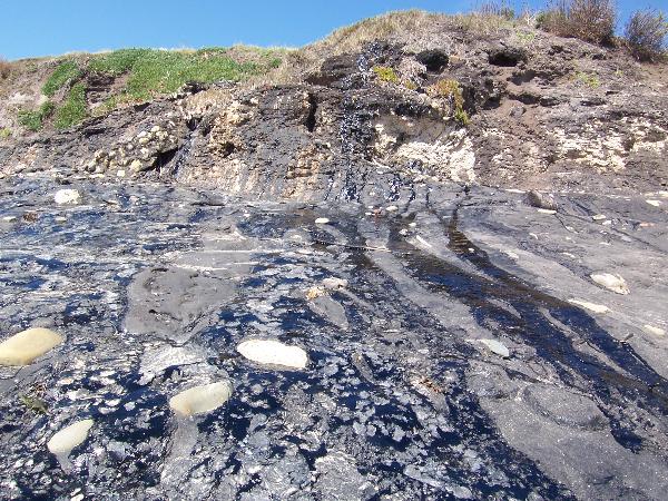
Today, tar continues to trap seashells, rocks, wave-rounded stones, and seaweed here and in other areas where the oil seeps from cliffs. Additionally, crude oil will flow from natural offshore seeps, depositing globs of oil on the shore.
Thanks to the City of Carpinteria’s Parks and Recreation Department for allowing the placement of this Earthcache.
_______________________________________________
The above information was compiled from the following sources:
- Richard J. Behl California State University, Long Beach, Monterey Formation, http://seis.natsci.csulb.edu/rbehl/Mont.htm
- HARTMAN MULTIMEDIA Carpinteria Asphalt Deposits http://www.californiawildflowers.info/Santa%20Barbara%20County/carpinteria_asphalt_deposits.htm
- Ventura Basin: Geologic Introduction and Field Trip Guidebook, Martin H. Link Editor, The Pacific Section American Association of Petroleum Geologists, Los Angeles, California and Los Angeles Basin Geologic Society, April 16, 1988 .