The posted coordinates should put you across the road from the slide. There is plenty of room to make your observations from the paved path between the rail and the road. There is no need to be in the road or cross any barriers.
In order to log this EarthCache, send me your answers to the following questions either through email or messaging from my profile page.
1: What type of landslide happened here?
2a: Is it still sliding?
2b: What do you see that supports your answer for #2?
3a: Has anything been done to reduce the risk or effect of future slides?
3b: Do you think this will help?
4a: Look around the area just beyond the slide, up the slope, along the road and down to the water. Do you think that by removing this part of the slope for the road, the slope was weakened making it more likely for a slide to happen and continue to happen?
4b: Give reasons for your answer to 4a.
5: Post a pic of you or a signature item with the overlook view in the background.
WHY HERE?
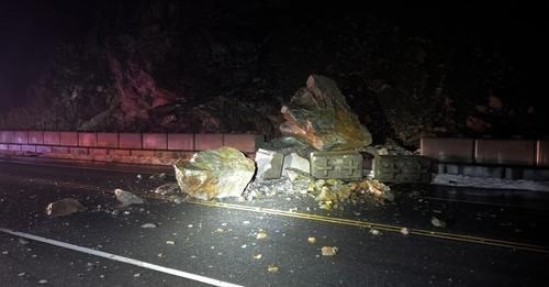
This is an active slide! The last major slide at this location prior to this EarthCache being published was on 2-12-2024. It brought huge boulders crashing down through the concrete barriers and resulted in the road being shut down temporarily while the debri was cleared.
On Tuesday, 8-18-2015, this was one of more than 50 landslides in the Sitka area. These were a result of heavy rain. The National Weather Service recorded over 2-and-a-half inches of rainfall in the six-hour period between 4 a.m. and 10 a.m.
The Sawmill Creek Road Slope is a 1/2 mile long ridge that is parallel to Sawmill Creek Road. The slope rises about 400 feet above Sawmill Creek Road. It has a rocky escapment with near vertical sections below the the ridge crest down to about 270 feet.
The landslide on 8-18-2015 consisted of soil, rocks, trees and bushes. It scoured a channel down to bedrock in the slope above Sawmill Creek Road and deposited debris across the road and beyond the buildings across the road up to about 5 deep feet in places.
While researching this location, I learned that a crew will begin removing some of the debris from the area at the base of the slide.
LANDSLIDE TYPES
The are 4 main types of landslides:
falls
topples
slides (rotational and translational)
flows
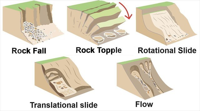
FALLS
Falls are landslides that involve the collapse of material from a cliff or steep slope. Falls usually involve a mixture of free fall through the air, bouncing or rolling. A fall-type landslide results in the collection of rock or debris near the base of a slope.
TOPPLES
Topple failures involve the forward rotation and movement of a mass of rock, earth or debris out of a slope. This kind of slope failure generally occurs around an axis (or point) at or near the base of the block of rock.
ROTATIONAL SLIDE
Rotational Slides are a slide in which the surface of rupture is curved concavely upward and the slide movement is roughly rotational about an axis that is parallel to the ground surface and transverse across the slide.
TRANSLATIONAL SLIDE
In a translational slide, the landslide mass moves along a roughly planar surface with little rotation or backward tilting
FLOW
Flows are landslides that involve the movement of material down a slope in the form of a fluid. Flows often leave behind a distinctive, upside-down funnel shaped deposit where the landslide material has stopped moving. There are different types of flows: mud, debris and rock.
references
https://www.mtpr.org/
https://www.bgs.ac.uk/
https://www.kcaw.org/
I have earned GSA's highest level:
 |