Dover Stone Church Preserve offers several miles of hiking trails that showcase the surrounding landscape. The preserve is best known for its natural cavern, which resembles the arch of a Gothic church. The unique cavern and scenic trails make the preserve a popular destination for hikers and other outdoor enthusiasts.
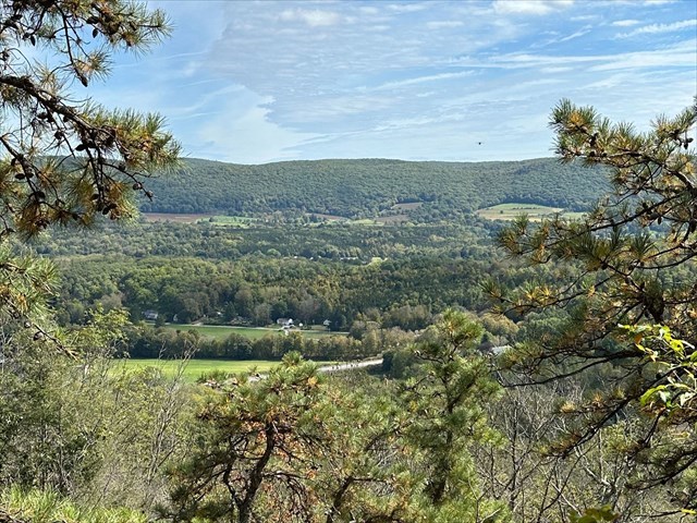
The Harlem Valley runs along the eastern edge of New York State, starting near the town of Pawling in Dutchess County and extending northward to the town of North East, near the border with Massachusetts. It is approximately 45 miles long and follows a path that parallels the Taconic Mountains to the east. In short, the Harlem Valley was formed through a combination of tectonic activity and glacial processes. During the Paleozoic Era, the collision of ancient landmasses caused folding and faulting, which helped shape the valley's underlying bedrock. Later, during the last Ice Age, glaciers carved out and deepened the valley, leaving behind glacial deposits and features like moraines and outwash plains. The retreat of the glaciers also shaped the drainage patterns and influenced the landscape visible in front of you.
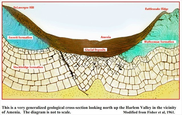
The image above is a simplified cross sectional view of the Harlem Valley in Amenia, NY which is approximately 9 miles north of here. It is important to note that it is not to scale and is intended to provide a visual to what the bedrock geology of the area. The Stockbridge Formation underlies most of the Harlem Valley, and on the west side of the valley is the Everett Formation, while the Walloomsac Formation lies on the east. Now let's learn more about each of these geologic formations. The Stockbridge Formation is predominantly made up of impure, gray to white, crystalline limestone and dolostone, and is often referred to as marble in more metamorphosed regions. It usually has a fine to medium grained texture and includes layers of calcareous shale. This creates a mix of carbonate rich and siliceous (containing silica) components. The presence of limestone and dolostone indicates that the Stockbridge Formation was originally deposited in a shallow marine environment, where carbonate sediments accumulated over time. Next is the Everett Formation is composed of grayish to greenish, fine to medium grained schist or phyllite that is foliated (layered). Its mineral makeup includes quartz (clear, crystalline), albite (white, translucent) or oligoclase (grayish, striated appearance), and muscovite (silvery and flaky), which contributes to its characteristic appearance. In some areas, the formation weathers to a rusty hue, and localized areas of dark gray to silvery schist or phyllite layers can be found. Lastly there is the Walloomsac Formation which is divided into two primary units. The lower unit consists of impure, calcitic marble, while the upper unit features interlayered black quartzitic schists and garnet-staurolite-muscovite-quartz schist.
Since where you are standing at Lookout Point is located on the west side of the Harlem Valley, we can expect to find rocks that are part of the Everett Formation in this area. As we learned earlier, the Everett Formation is composed predominantly of schist and phyllite. They are both metamorphic rocks, can be distinguished by their texture, grain size, and mineral alignment. Schist typically features larger, visible mineral grains and a more pronounced foliation, with grains often exceeding 0.1 mm. As a result it has a coarser appearance. In contrast, phyllite has smaller grains, usually less than 0.1 mm, which results in a smoother texture. The mineral alignment also differs; schist displays a distinct alignment of minerals, creating a shiny, reflective surface due to the larger mica flakes (such as muscovite or biotite). In contrast phyllite, while foliated as well, has a more subtle luster and is described as having a “phyllitic luster” which is less pronounced than that of schist.
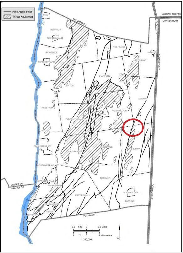
One other topic worth mentioning involves tectonic activity. The map above shows the location of high angle and thrust faults in Dutchess County. The black lines indicate high angle faults, while the shaded areas represent thrust faults. Circled in red is the area where you are standing. High angle faults are characterized by a steep angle of inclination, typically greater than 30 degrees, and involve vertical or near vertical movements of rock layers. In contrast, thrust faults have a low angle of inclination, usually less than 30 degrees, which allows one block of rock to be pushed over another. Thrust faults often result from compressional forces, causing the rocks to fold and fault, while high angle faults can be associated with extensional or compressional settings, which depends on the direction of movement.
Logging Requirements:
- Describe the characteristics (color, texture, grain size...etc) of some of the exposed bedrock visible at Lookout Point. Based on the description, what type of rock do you think this is and why?
- From the map showing Faults in Dutchess County, it can be seen that this area contains both high angle and thrust faults. Based on your observations, which type of fault is dominant here? How do you think it contributed to the topography of the Harlem Valley visible in front of you?
- Upload a photo taken at Lookout Point. You don't have to be in the photo, though it is strongly encouraged.
Sources:
- https://portal.ct.gov/-/media/deep/geology/quadreports/qr38pamphletpdf.pdf
- https://dutchessemc.org/wp-content/uploads/2009/10/c3geology.pdf