Read note at base of cache page for access details.
Boppy Mountain
Boppy Mountain is a lesser-known place along the Barrier Highway, located about 2km northwest of the small town of Canbelego. Offering 360-degree views over the plains, it is accessible from all directions, and you can drive to within 100m of GZ, from which you are only a short scramble/climb from the top. Be careful when exploring around, the area has lots of loose pebbles some large drops and steep slopes. There is also a trigonometric pin at the top of the hill, under a few rocks near the large cairn, surrounded by some concrete for those interested.
Geology
The rocks are of a sedimentary type known as "conglomerate". They consist of river-tumbled pebbles which were naturally cemented together almost 350 million years ago. Over the years. Movement in the earth's crust has uplifted the conglomerate from the drainage basin where it was originally deposited. Tilting of the sediment layers and erosion by wind and water has left this rocky outcrop of Boppy Mountain as it is today.
Conglomerate rock is a clastic sedimentary rock composed of rounded gravel and boulder-sized clasts that are cemented together. The clasts can be made of any rock, whether it be sedimentary, metamorphic or igneous, but the clast cement is usually composed of calcite, silica or silt
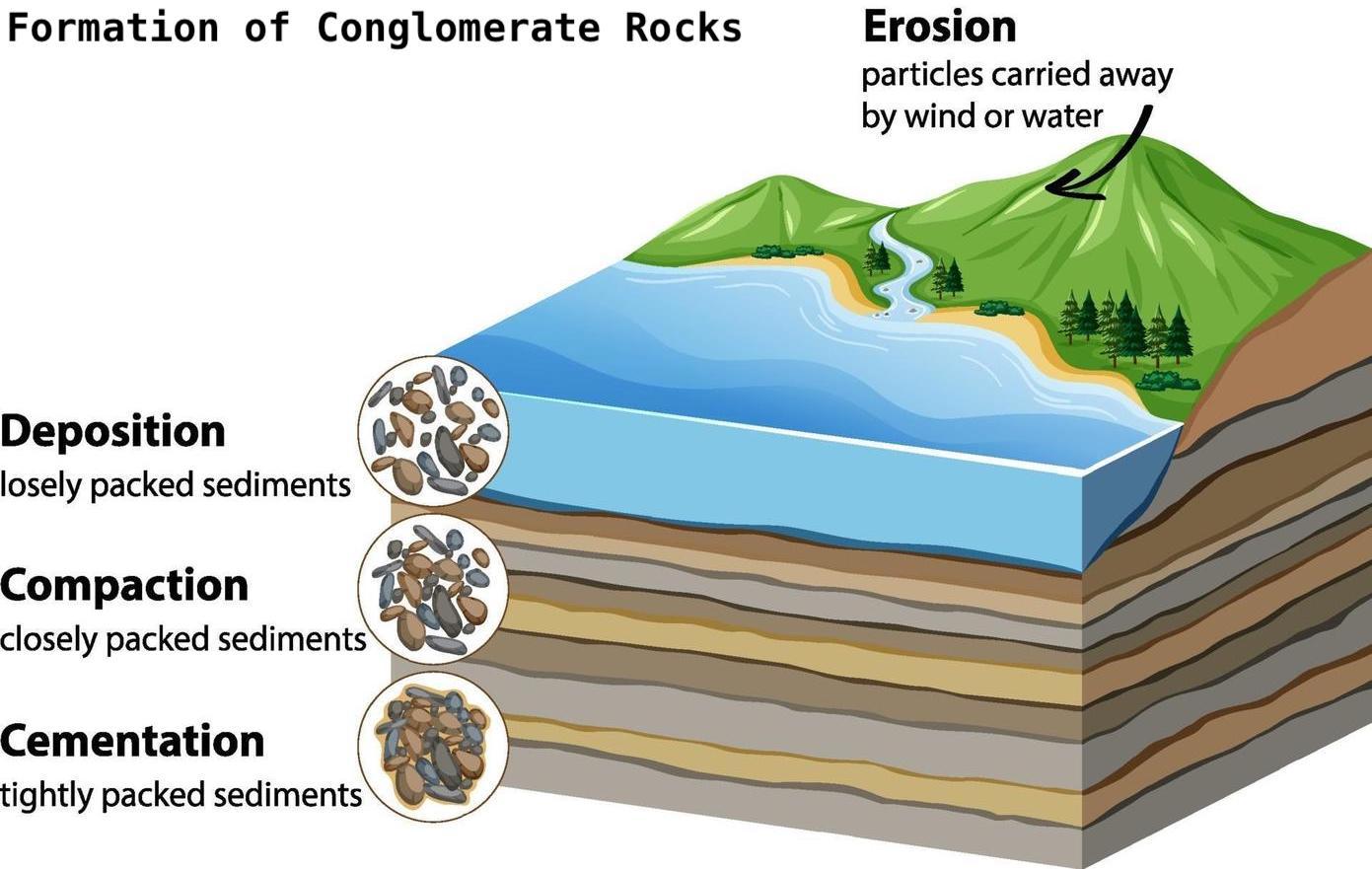
Conglomerate rock formation begins with the weathering of existing rocks due to various processes like physical, chemical, or biological factors, causing them to break into smaller fragments. These fragments are then transported by natural agents such as rivers, streams, glaciers, wind, or gravity.
As these agents lose energy, they deposit the rock fragments in areas where the flow slows down, resulting in deposition sites like riverbeds, alluvial fans, or coastal regions. During deposition, the fragments are sorted based on size and weight, with larger ones settling at the bottom and smaller ones higher up in sediment layers. Over time, pressure from overlying layers compacts the sediment below, while groundwater carrying dissolved minerals infiltrates the sediment and acts as cement, binding the rock fragments together. This cementation process gradually solidifies the sediment into conglomerate sedimentary rock.
Conglomerates can be formed in a high or low energy environment, in high-energy environments, like beachfronts and flowing rivers, the inclusions are usually smooth and in no particular orders or layers. In low-energy environments, there is often layering present (larger and denser rocks lower, smaller and lighter rocks higher) along with more sharp and rough rocks.
Logging Requirements
To log this cache, you will need to answer some questions and take a photo for your online log. You may log your find immediately - we will reply to all messages and emails. If we do not receive your answers and photo within 10-14 days, your log will be deleted. You are welcome to include your photo in your log, just do not give away any of the answers
All questions can be answered from the posted coordinates, along with the photo taken there.
Question 1
Take a look around nearby and find some conglomerate- That shouldn't be too hard. Have a look at the inclusions, and describe the overall size range, texture, colour and shape of said inclusions.
Question 2
Do you think this conglomerate formed in a low-energy or a high-energy environment? Justify your answer.
Photo Requirement
Post a photo of yourself, your GPSr, your caching name or one of your personal belongings at the top of the hill, facing any direction, similar to the one shown below.

- Access -
To access the EarthCache, you will need to travel through a section of inclosed lands, as per the sign on the gate at the trailhead WP. The sign clearly states that entry to inclosed lands from the road is prohibited.
The sign does not prohibit access along the road, and you do not need to leave the road within the boundaries of the inclosed lands to access the EarthCache.