Rappel concernant les « Earthcaches »
ATTENTION, il n'y a pas de conteneur à rechercher ni de logbook à renseigner. Il suffit de se rendre sur les lieux d'observations puis de réaliser les conditions de validation ci-dessous.
Une Earthcache ayant comme objectif de mettre en pratique une leçon de géologie par des observations de terrain, il est conseillé de lire le descriptif afin de vous aider à répondre aux questions.
Questions pour valider la cache géologique
Point 1 : N 48° 21.010 W 003° 56.817
- Question 1 : Depuis le parking, observez l'ensemble du Mont Saint Michel de Brasparts. Quelle couleur prend globalement le Mont ? Au soleil, quelle impression vous donne cette roche ?
Point 2 : N 48° 20.998 W 003° 56.782
Pendant l'ascension, vous voici près d'un bloc contre les escaliers (photo WP2).
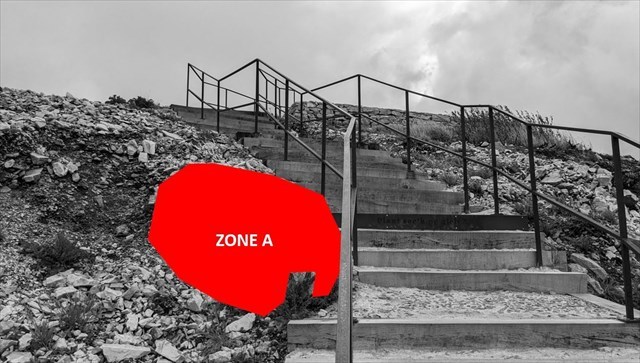
- Question 2 : Décrivez la roche formant ce bloc. Déduisez-en sa nature.
- Question 3 : Essayez de rayer cette roche avec une lame de métal. Y arrivez-vous ? Déduisez-en sa dureté sur l'échelle de Mohs.
Point 3 : N 48° 21.021 W 003° 56.739
- Question 4 : Avec votre GPS, déterminez l'altitude de cette roche puis observez les régions environnantes et leur altitudes relatives à celle du Mont.
Expliquez avec vos propres mots pourquoi le Mont Saint Michel de Brasparts est à cette altitude particulière (les réponses à la question 3 et le descriptif peuvent vous aider).
- Question 5 : Prenez une photo de vous ou votre pseudo avec le panorama ou la chapelle de Saint Michel de Brasparts.
Cette photo devra au choix nous être transmise avec les réponses ou être ajoutée à votre log.
Vous pouvez vous loguer sans attendre notre confirmation,
mais vous devez nous envoyer les réponses en même temps soit par mail via notre profil (
fafahakkai), soit via la messagerie geocaching.com (Message Center).
S'il y a des problèmes avec vos réponses nous vous en ferons part.
Les logs enregistrés sans réponse seront supprimés.
Et en théorie, cela donne quoi ?
► Contexte géologique local
A l'est de Saint Rivoal, le mont Saint-Michel de Brasparts est l'un des sommets de la chaîne des monts d'Arrée et domine du haut de ces 381 mètres d'altitude la cuvette des tourbières du Yeun Elez et le réservoir de Saint Michel.
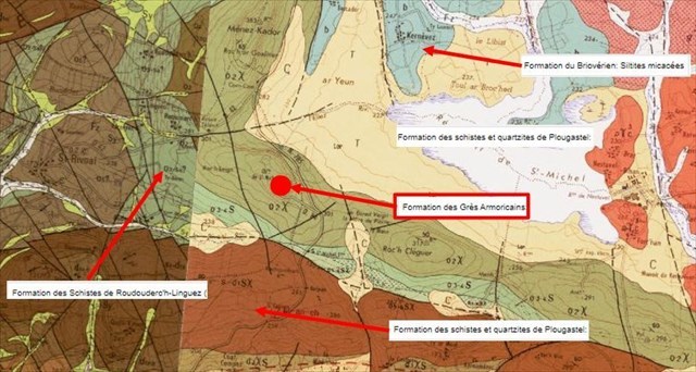
L'étude de la carte géologique local caractérise la position de ce Mont sur une roche particulière, le Grès armoricain de l'Arénigien, qui le distingue des formations schisteuses environnantes et explique dans cette différence de formation rocheuse la topographie de la région.
► Le Grès armoricain, une drôle de formation
Le Grès armoricain est d’âge Ordovicien inférieur, plus précisément Arénigien (480 à 465 Ma).
Il s'agit d'une formation sédimentaire gréseuse faiblement métamorphisée suite aux pressions consécutives à l'orogenèse hercynienne.
Ces grès quartzitiques sont globalement gris clairs avec une texture finement grenue.
Les grains de quartz se sont tout d'abord cimentés en un grès, une roche sédimentaire détritique puis sous la pression en partie transformé en quartzite, une roche siliceuse métamorphique constituée de cristaux de quartz soudés.
Ce début de métamorphisation a donné des grains de quartz soudés et non uniquement cimentés. Le fait de frotter la roche ne permet ainsi pas d'en détacher les grains.
Cela en fait une roche beaucoup plus dur qu'un grès ou un schiste sédimentaire.

► L'Erosion différentielle
L'érosion différentielle est la composante d'irrégularité de l'érosion résultant des différences de résistance des matériaux.
Elle provoque une mise en relief des zones résistantes au détriment des zones tendres et impacte fortement la topographie des paysages, les points culminants étant souvent fait d'une roche plus résistante à l'érosion et qui a protégé à cet endroit les couches inférieures plus tendres.
La sensibilité à l'érosion est souvent liée à la notion de dureté d'une roche. Celle-ci est évaluée par une échelle relative ordinale (comparaison de la capacité de l'un à rayer l'autre), l'Echelle de Mohs.

Ainsi les différentes formations schisteuses visibles sur la carte géologique et entourant la formation de grès armoricain se raie avec une clef en métal et présente donc une dureté maximale de 5 sur cette échelle.
A reminder about Earthcaches
ATTENTION, there is no container to look for or logbook to fill in. All you have to do is go to the observation sites and complete the validation conditions below.
As the aim of a geology cache is to put a geology lesson into practice by making observations in the field, you are advised to read the description to help you answer the questions.
Questions to validate the Earthcache
Point 1 : N 48° 21.010 W 003° 56.817
- Question 1 : From the car park, look at the whole of Mont Saint Michel in Brasparts. What is the overall colour of the Mont? In sunlight, what impression does this rock give you?
Point 2 : N 48° 20.998 W 003° 56.782
During your ascent, here you are near a boulder against the stairs (photo WP2).
- Question 2 : Describe the rock forming this boulder. From this, deduce its nature.
- Question 3 : Try to scratch the rock with a metal blade. Can you do it? Deduce its hardness on the Mohs scale.
Point 3 : N 48° 21.021 W 003° 56.739
- Question 4 : Using your GPS, determine the altitude of this rock and then look at the surrounding regions and their altitudes relative to that of Mont Blanc. Explain in your own words why the Mont Saint Michel in Brasparts is at this particular altitude (the answers to question 3 and the description may help you).
- Question 5 : Take a photo of yourself or your pseudonym with the panorama or the chapel of Saint Michel de Brasparts.
This photo can either be sent to us with your answers or added to your log.
You can log this cache without waiting for our confirmation,
but you must send us the answers at the same time, by e-mail via our profile (
fafahakkai) or by the system of Message Center of geocaching.com.
If there is a problem with your answers we will notify you.
The logs recorded without answers will be deleted.
What does this mean in theory?
► Local geological context
To the east of Saint Rivoal, Mont Saint-Michel de Brasparts is one of the peaks in the Monts d'Arrée chain, towering 381 metres above the Yeun Elez peat bog basin and the Saint Michel reservoir.
A study of the local geological map reveals that this mountain is situated on a particular rock, the Armorican sandstone of the Arénigien period, which distinguishes it from the surrounding schist formations and explains the topography of the region in this difference in rock formation.
► Armorican Sandstone, a strange formation
The Armorican Sandstone is Lower Ordovician, or more precisely, Arenigian (480 to 465 Ma) in age.
It is a sandstone sedimentary formation that has undergone slight metamorphism as a result of the pressures of the Hercynian orogeny.
These quartzite sandstones are generally light grey with a fine grained texture.
The quartz grains were first cemented together to form sandstone, a detrital sedimentary rock that was then partly transformed under pressure into quartzite, a siliceous metamorphic rock made up of fused quartz crystals.
This early metamorphism produced fused quartz grains, not just cemented ones. Rubbing the rock does not loosen the grains.
This makes it a much harder rock than sedimentary sandstone or shale.
► Differential erosion
Differential erosion is the irregularity component of erosion resulting from differences in the strength of materials.
It causes resistant areas to be highlighted to the detriment of softer areas and has a strong impact on the topography of landscapes, with the highest points often made of rock that is more resistant to erosion and has protected the softer lower layers at that point.
Sensitivity to erosion is often linked to the notion of a rock's hardness. This is assessed using a relative ordinal scale (comparing the ability of one rock to scratch another), the Mohs scale.
The various schist formations visible on the geological map and surrounding the Armorican sandstone formation can be scratched with a metal key and therefore have a maximum hardness of 5 on this scale.
► Sources bibliographiques / Bibliographical sources