Skip to content

Čeľuste (SK/EN) EarthCache

Hidden : 10/15/2024
Difficulty:
2 out of 5
Terrain:
1.5 out of 5

Size: Size:   other (other)

Join now to view geocache location details. It's free!

Watch

How Geocaching Works

Please note Use of geocaching.com services is subject to the terms and conditions in our disclaimer.

Geocache Description:


Pre zalogovanie kešky nie je nutné liezť na pieskovú stenu.

Keška

Nachádzate sa na v opustenej pieskovni v Príbelciach. Autom sa dostanete až na lokalitu, prípadne ho môžete zaparkovať pri kostole/cintoríne a prejsť sa do pieskovne pešo. Piesková stena, pred stojíte, je výsledkom usadzovania v plytkom mori stredného miocénu, posledného obdobia, kedy sa na Slovensku vyskytovalo more.

Piesková stena

Pieskovňa v Príbelciach je známa výskytom žraločích zubov. Tie sa však nehľadajú ľahko, tak sa budeme venovať len pozorovateľným textúram sedimentov. Samozrejme, povieme si niečo aj o žralokoch, resp. všeobecne o živote v pravekom mori, no hľadanie zubov nechávam na vás. Ak vám môžem odporučiť, skúste hľadať na miestach, označených waypointami O1 a O2. A rezervujte si naň dostatok času (a trpezlivosti ;-).

Podmienky logovania

Earthcache nemá fyzický logbook kde sa môžete zapísať. Aby ste mohli zalogovať návštevu, musíte zodpovedať na nasledovné otázky a zaslať mi odpovede na profilový e-mail, alebo cez message centrum.

Zalogovať môžete okamžite po odoslaní odpovedí, nemusíte čakať na potvrdenie ich správnosti. Dodržuje prosím následnosť: 1) poslanie odpovedí na úlohy; 2) logovanie.


  1. Pozorujte steny pieskovne. Dokážete v nich vypozorovať nejaké jednotlivé vrstvy?
  2. Akým spôsobom sú tieto vrstvy usporiadané? Sú rovnobežné, rôznobežné?
  3. Aký záver viete zo svojho pozorovania vyvodiť? V akom prstredí vrstvy vznikli? Akým procesom?

Fotografia nie je súčasťou úloh, ale ako dôkaz návštevy mám právo o ňu požiadať, tak ako je to uvedené v Help Centre.

  • Poprosím teda o fotku Vás, alebo vašej osobnej veci takým spôsobom, aby ste boli jednoznačne identifikovateľný na lokalite.

  • Bez doručených odpovedí je log neplatný a bez ďalšieho upozorňovania ho zmažem.
  • Skupinové odlovy - každý posiela odpovede sám za seba.

A na záver - nebojte sa odpovedí, skúste ;-)
A čítajte listing, možno Vám to pomôže.

Sedimentácia

Prevažná väčšina usadených hornín vzniká v morskom prostredí. Či už ide o bridlice a rohovce, pochádzajúce z najväčších hĺbok oceánov, vápencové masívy s hrúbkou niekoľko desiatok až stovák metrov, ktoré a usadzujú v rozľahlách morských panvách, až po jemnozrnné piesky morského pobrežia, prepracúvané príbojom.

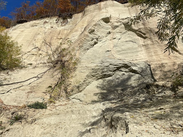
Vrstvy piesku z pobrežia treťohorného mora v Príbelciach.

Sedimenty sú rôzne veľké úlomky hornín, ktoré vznikli zvetrávaním a sú prenášané na miesto uloženia. Čo môže byť nejaká panva, ale aj pobrežná zóna, ústie rieky, dno jazera... Proste miesto, kde prevládne gravitačná sila nad silou presúvajúcou úlomky a tie klesajú smerom dole. Okrem gravitácie, ktorá je hlavným "motorom" usadzovania, môžu pôsobiť aj iné faktory (napr. zmena pH, koncentrácie rozpustených látok, elektrostatické sily). A taktiež treba uviesť, že nielen voda dokáže premiestňovať úlomky, ale aj vietor a ľadovec. Prípadne sa úlomky skál zosunú po úpätí svahu len vplyvom gravitácie.

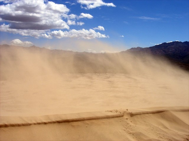
Duny v Mohavskej púšti ako výsledok transportu piesku silou vetra.

Po usadení úlomkov a ich následnom prekrývaní ďaľšou a ďaľšou vrstvou sa spúšťa súbor fyzikálno-chemických procesov, keď z pôvodne nespevnených sedimentov vznikne pevná, usadená hornina. Tento proces sa nazýva diagenéza a dochádza pri ňom k stláčaniu (kompakcii) a "zlepeniu" jednotlivých úlomkov sedimentu cementom (väčšinou vyzrážaný kalcit, kremeň, pyrit).

Šikmé/krížové zvrstvenie

Vrstevnatosť sa aj po diagenéze zachová a z tvaru, orientácie a hrúbky vrstiev sa dá spätne zrekonštruovať prostredie, v ktorom sa sediment usadzoval. Na základe orientácie sa primárne rozlišujú vodorovné a šikmé zvrstvenie. Ďalej poznáme korytové a šošovkové zvrstvenie. Ak v rámci vrstvy môžeme pozorovať zmeny v zrnitosti, vtedy hovoríme o gradačnom (pozitívnom, alebo negatívnom) zvstvení.

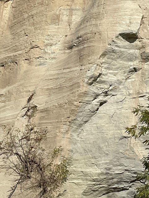
Šikmé/krížové zvrstvenie v pieskovni v Príbelciach.

Pre pobrežné morské zóny, akou bola aj pieskovňa v Príbelciach, je charakteristické krížové zvrstvenie, t.j. striedanie sa protibežných šikmých vrstiev.

Schéma vzniku šikmého zvrstvenia.
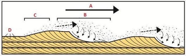
Schéma vzniku šikmého zvrstvenia. Legenda:
  • A: smer prúdenia
  • B: zóna ukladania
  • C: zóna erózie
  • D: šikmé zvrstvenie

Šikmé zvrstvenie vo všeobecnosti indikuje pohybujúci sa tok. To však platí, iba ak sú jednotlivé plochy orientované rovnobežne. Ak sa orientácia vrstiev strieda, t.j. raz sú uložené pod jedným a raz pod opačným uhlom, vtedy hovoríme o zvrstvení krížovom. Príčinou protibežnosti je pravidelné striedanie sa smeru prúdenia, čo je typické pre príbrežné morské zóny, formované príbojom.

Príbelské vrstvy

Steny pieskovne v Príbelciach odkrývajú pobrežné piesky treťohorného mora, ktoré sa v týchto miestach rozlievalo približne pred 16 miliónmi rokov. Teda, ono sa tu rozlievalo aj skôr, no 16 miliónov rokov jej vek začiatku jeho konca. More to bolo teplé, subtropické, tak ako bola subtropická klíma v celej vtedajšej Európe. Pre porovnanie: ak teraz hovoríme o globálnom otepľovaní, vtedajšia priemerná ročná teplota bola o 3 °C vyššia, ako dnešná.

Nepravdepodobné stretnutia v treťohornom mori.

More bolo súčasťou svetového oceánu Tethys, ktorý sa však s nástupom alpínskeho vrásnenia rozdelil a jeho severná časť postupne zanikla. Vyvinuli sa tu bizarné formy života, ako napríklad trpasličia veľryba Cetotherium riabinini a pod morskou hladinou sa preháňali žraloky, medzi nimi naopak aj najväčší žralok Otodus megalodon (žralok veľkozubý), ktorého zuby sa našli vo viacerých lokalitách v Novohrade.

Porovnanie veľkosti žralokov.
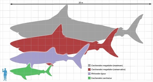
Porovnanie veľkosti žralokov.Legenda:
- Megalodon, maximálny odhad veľkosti
- Megalodon, konzervatívny odhad veľkosti
- Žralok veľrybí (Rhincodon typus)
- Žralok modrý (Carcharodon carcharias)

Žraločie zuby sa tu vyskytujú pomerne hojne, celkový počet nálezov sa odhaduje na tisícky kusov a na desiatky druhov. No na iné fosílie, čo sa týka výskytu, je pieskovňa chudobná.

To log this cache, you don't have to climb the sand wall.

Cache

You are in an abandoned sand quarry near Príbelce. You can drive to the site, or you can park your car near the church/cemetery and walk to the quarry by foot. The sand wall in front of you is the result of sedimentation in the shallow sea of ​​the Middle Miocene, the last period when there was a sea in Slovakia.

Sand wall

The sand quarry in Príbelce is well known for the occurrence of shark teeth. However, they are not easy to find, so we will focus only on observable sedimentary textures. Of course, we will also talk about sharks, or generally, about life in the prehistoric seas in general, but I leave the search for teeth to you. If I may recommend, try searching in the places marked as waypoints O1 and O2. And set aside enough time (and patience ;-).

Logging conditions

EarthCache does not have a physical logbook. In order to log a visit, you must answer the following questions and send me the answers through my profile e-mail, or through Message center.

You can log immediately after sending the answers, you don't have to wait for confirmation of their correctness. Follow this sequence please: 1) sending answers; 2) log.


  1. Observe the sand walls. Can you identify any individual layers in them?
  2. How are these layers arranged? Are they parallel, divergent?
  3. What conclusion can you draw from your observation? In what environment did the layers form? By what process?

Photography itself is not a part of tasks, but I can request it as a proof of visit, as stated in the Help Center.

  • So, I kindly ask you a photo of you, your navigation device, your XWG... Just something that clearly identifies you on the site.

  • Without received answers, the log is invalid and I will delete it without further notice.
  • No group logging - everyone sends answers for himself.

And most of all - don't be afraid of the answers, just try ;-)
And read the listing, maybe it will help you.

Sedimentation

The majority of sedimentary rocks are formed in the marine environment. Whether it is slate and shale, originating from the deepest parts of the oceans, limestone massifs with a thickness of several tens to hundreds of meters, which are deposited in extensive sea basins, or fine-grained sands of the sea coast, made by the tidal waves.

Sands from the coast of the Tertiary sea in Príbelce.

Sediments are variously sized fragments of rocks that were formed by weathering and are transported to the place of deposition. Which can be a sea basin, but also a coastal zone, a river mouth, a lake bottom... Simply a place where the force of gravity prevails over the force moving the fragments and they fall downwards. In addition to gravity, which is the main force of sedimentation, other factors can also act (e.g., changes in pH, concentrations of dissolved substances, electrostatic forces). It should also be noted that not only water can move fragments, but also wind and glaciers. Or rock fragments will slide down the slope due to gravity alone.

Dunes in the Mojave Desert as a result of sand transport by wind.

After the fragments have settled and are subsequently covered by another layer, a set of mechanical and chemical processes are triggered, when a solid, settled rock is formed from the originally unconsolidated sediments. This process is called diagenesis and involves compression (compaction) and joining of individual sediment fragments with cement (mostly precipitated calcite, quartz, pyrite).

Cross bedding

The stratification is preserved even after diagenesis and the environment in which the sediment was deposited can be reconstructed from the shape, orientation and thickness of the layers. Based on the orientation, normal and cross-stratification are primarily distinguished. If we focus on the distribution of the clasts size in a layer, then we speak about normal or inverse graded bedding.

Cross-bedding in the sand wall in Príbelce.

Coastal zones, such as the sand quarry in Príbelce, are characterized by cross-bedding, wich is layered within a stratum and at an angle to the main bedding plane.

Scheme of the formation of oblique stratification.
Scheme of the formation of oblique stratification. Legend:
  • A: flow direction
  • B: deposition zone
  • C: erosion zone
  • D: cross-bedding

Cross-bedding forms during deposition on the inclined surfaces of bedforms such as ripples and dunes; it indicates that the depositional environment contained a flowing medium (typically water or wind). Environments in which water movement is fast enough and deep enough to develop large-scale bed forms fall into three natural groupings: rivers, tide-dominated coastal and marine settings.

Príbelce formation

The sand walls in Príbelce reveal the coastal sands of the Tertiary sea, which spread in these places approximately 16 million years ago. It spread here even earlier, but this is the age of the beginning of its end. The sea was warm, subtropical, like the climate in all of Europe at that time. For comparison: if we are now talking about global warming, the average annual temperature at that time was 3 °C higher than today.

Unprobably encounters in the Tertiary sea.

The sea was part of the Tethys ocean, which, however, split with the rising of the Alpine orogeny and its northern part gradually disappeared. Bizarre life forms have developed here, such as the dwarf whale Cetotherium riabinini, and sharks roamed beneath the sea surface, including the largest shark Otodus megalodon, whose teeth have been found in several locations in Novohrad.

Comparison of shark sizes.
Comparison of shark sizes. Legend:
- Megalodon, maximum size estimate
- Megalodon, conservative size estimate
- Whale shark (Rhincodon typus)
- Blue shark (Carcharodon carcharias)

Shark teeth are relatively abundant here, the total number of finds is estimated at thousands of pieces and dozens of species. However, the sands are poor for other fossils.

Zdroje/sources

  • Konečný, V. (ed.), 1978: Geologická mapa Ipeľskej kotliny a južnej časti Krupinskej planiny 1: 50 000 GÚDŠ, Bratislava (sk)
  • Konečný, V., (ed.), 1983: Vysvetlivky ku geologickej mape Ipeľskej kotliny a južnej časti Krupinskej planiny 1: 50 000 GÚDŠ, Bratislava. 126 s. (sk)
  • Vass, D., Konečný, V., Šefara, J. (eds.), 1979: Geologická stavba Ipeĺskej kotliny a Krupinskej planiny GÚDŠ, Bratislava. 277 s. (sk)
  • Ledvák, P., 2019: Zuby žralokov spodnobádenských sedimentov lokality Príbelce (okres Veľký Krtíš). Natura Carpatica, LX, s. 7 – 24. (sk)
  • Holec, P., Hornáček, M., Sýkora, M., 1995: Spodnomiocénna fauna žralokov (Clwndrichthyes, Elasmobranchii) a veľrýb (Mammalia, Cetacea) od Mučína na južnom Slovensku. Geologické práce, 100, s. 37 – 53. (sk)
  • Skupien, P., Vašíček, Z.,: Multimediální texty ze sedimentologie web (cz)
  • Významné geologické lokality: web (sk)
  • Wikipedia: Sedimentácia, Transpor sedimentov, Diagenéza, Sedimentárne štruktúry (en)

Additional Hints (No hints available.)