
このキャッシュの学習目的は、蛇行をもっとよく知ることだ。蛇行は、大編成でも小編成でも、全国にはっきりと見られる。大編は、小川や小さなオスに比べて、その範囲が川の大きさと一致するため、このことについて考えない傾向がある。蛇行という現象は、緩い堆積物で覆われた非常に緩やかな傾斜地を流れる河川の規則的な曲がり角のことである。湾曲の弧が半円より大きくなると、蛇行と呼ばれる。場所を調べたり、説明の文章を参考にしたりすることで、これを詳しく見ることができ、さらに下の質問に答えるための良い基礎ができるだろう。お楽しみください!
The learning purpose of this cache is to get to know meandering better. Meandering is clearly visible all over the country, in both large and small editions. The large editions tend not to think about this as the scope falls more in line with the size of the river, compared to a stream or a small os. The phenomenon of meanders are regular bends in rivers that run over very gently sloping ground covered with loose deposits. When the arc of the bends becomes larger than a semicircle, they are called serpentines (snake bends). You will have a closer look at this by studying the location and with the help of the text in the description, and you will have a good basis for answering the questions further down. Enjoy!
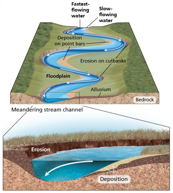
主な特徴:
蛇行は、その設計に基づいて特定のタイプの河川を特徴付けるために使用される。支流には、編組型、直線型、曲線型または蛇行型の3つのタイプがある。氾濫原を流れる河川では、通常、勾配が小さいと蛇行が形成されやすい。
土砂は通常、ジグザグにコブに堆積し、そこから岸に移動する。凹部では浸食が支配的で、遠心力によって盛り土が後退する様子がよくわかる。凸部の盛り土の前進と凹部の後退が組み合わさると、川の流れが移動し始め、蛇行が発生する。
その主な特徴は、河床に形成される非常に明瞭な蛇行曲線であるため、他のタイプの河川との識別や区別は容易である。
蛇行流が非常に大きなカーブを描くと、川の流れが変わることがある。平野部など、ある特定の地域では常に動いているので、ある時期にいわゆる蛇行した形の湖を形成することもある。川の蛇行過程は、流れや水の速さ、それを構成する物質によって異なるため、それぞれ異なる。
Main characteristics:
Meandering are used to characterize specific types of rivers based on their design. There are three types of tributaries: braided, straight and curved or serpentine. In the rivers that flow through the floodplain, meandering are usually easier to form when the slope is small.
The sediment is usually deposited in the bump in a zigzag fashion and then moves from there to the shore. In the recesses, erosion dominates, and it is clear how the filling retreats due to the centrifugal force. When the advance of the fill in the convex zone is combined with the retreat of the concave zone, the river course begins to migrate and meandering occur.
It is easy to identify or distinguish from other types of rivers, because its main characteristic is the very clear meandering curve it forms in the river bed.
When the meandering current forms a very large curve, it can cause the river course to change. They are constantly moving in certain areas, for example the plains, so they can form a so-called meander-shaped lake at a certain time. The meandering process of each river is different because it depends on the current, the speed of the water and the materials that make it up.
蛇行:
川の水は常に一方向に流れるが、その方向は地形の傾斜によって決まる。試しに簡単な実験をしてみよう。パイプに水を入れると、水を満たすスピードが速くなったり遅くなったりするのがわかる。
川底も同じである。水は水路の中を流れる。地形が急であればあるほど、水流の速度は大きくなり、したがって水路にかかる力も大きくなる。この力が土地を侵食し、河道を湾曲させる。
川が多孔質で浸透性の表面を移動するにつれて、川が流れ続ける自然の通路の端が浸食される。摩耗が進むと、特徴的な凹形状となり、カーブができる。
地質学者によると、蛇行は腐食、侵食、摩耗の3段階で起こる。まず、水の急激な力、あるいは水の圧力が川岸を腐食させ、土や石や岩を運び去る。
水の力によって移動した物質が川底を侵食するのだ。最後に、粒子は分離して衝突する。これが摩耗を引き起こし、河床の基礎を破壊する力を増大させる。
外側への浸食が曲線を形成するのと同じように、土砂は対岸にも堆積し、曲線の凸面または内側を形成する。河道は通常、河川の中流域と下流域で形成され、源流域で形成されることはまれである。これは、河川の下流部または中流部で、流れが最大の圧力と力を生み出すからである。蛇行は景観を変え、河川の流路を変えることさえある。
Meandering:
The water in a river always flows in one direction, which is determined by the slope of the terrain over which it moves, even if the surface sometimes appears flat. To test it, you can do a simple experiment. Put the water into the pipe, it can be seen that the water filling speed increases or decreases; the speed depends on the slope of the pipe.
The same applies to the river bed. The water flows in the channel; the steeper the terrain, the greater the speed of the water flow and therefore the greater the force on it. It is this force that erodes the land, causing the river channel to take on a curved shape.
As the river moves over the porous, permeable surface, the edges of the natural passage through which the river continues to flow are eroded. As it wears out, it takes on a characteristic concave shape, which creates a curve.
According to geologists, the meandering process occurs in three stages: corrosion, erosion and wear. First, the rapid force of the water or the pressure of the water corrodes the river bank and carries away soil, stones and rocks.
So this material moved by the force of the water helps to erode the river bed. Finally, the particles collide into the separated and colliding elements; this causes wear, which increases the force that destroys the foundations of the river bed.
In the same way that outward erosion forms a curve, sediment also accumulates on the opposite bank, forming the convex or inner side of the curve. Fluvial channels are usually formed in the middle and lower reaches of rivers; rarely occurs at the source. This is because it is in the lower or middle part of the river where the current produces the greatest pressure and force. Meandering can change the landscape and even change the course of the river.
このキャッシュを記録する
このキャッシュを記録するためには、アースキャッシュの座標に関連した質問に答えなければなりません。
答えが集まったら、確認のためCOに送ってください。
回答がCOに送られた後、すぐにログを取ることができます。あなたの答えに質問がある場合は、COがあなたに連絡します。
COへの回答がないログや、COからの質問が保留されているログは予告なく削除されます。
質問の答えとなるような写真をログに含めないでください。
To log this cache.
To get to log this cache you will have to visit and answer the questions which are related to the coordinates given the earthcache.
When answers are collected, send them to CO for verification.
You can log immediately after answers are sent CO. If there are any questions about your answers CO will contact you.
Logs without answers to CO or with pending questions from CO will be deleted without any further notice.
Please do not include pictures in your log that may answer the questions.
質問
1. 以下の質問に答えてください。
A. 蛇行を観察し、gz地点の蛇行内側の湾曲部に見られる砂利/石の粒子の大きさを記録しなさい。A1)その塊は何らかの方法で選別されていると主張したいのですか?B1)最も大きな砂利や石の粒子の大きさはどのくらいか? (水位が高すぎる場合は、理論に基づいて答えることができる)
B. なぜ砂利や石の粒子は内側の湾曲部にとどまっているのか、説明しなさい。また、なぜ大小の粒子が異なる場所に分布しているのか?
C. 将来、川が自由に蛇行するようになったとしたら、十分な時間が経った後、この蛇行はどのようになるでしょうか?
2. その場所から、あなた、グループ、またはGPSの写真を、答えを明かさずに撮ってください。
Questions:
1. Answer the questions below by visiting the coordinates.
A. Study the meander and note the size of the gravel/stone particles that you find in the inner bend of the meandering at gz. A1) Do you want to claim that the mass is sorted in some way? B1) How big are the largest gravel/stone particles? (If the water level is too high, you can answer based on theory.)
B. Explain why the gravel/stone particles remain in the inside bend here? And why is it distributed with small and large particles in different places?
C. If the river is allowed to wander freely in the future - what will this meander look like after long enough time?
2. Take a photo of you, the group or the GPS from the location without revealing any of the answers.