|

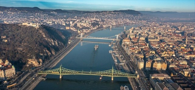
🇭🇺 A következő EarthCache-em a Duna kanyargós folyamatát mutatja be.
🇬🇧 My next EarthCache is going to show you the meandering process of Danube.
Meandering
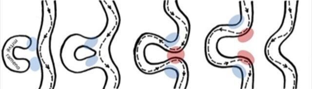
🇭🇺 A középső és alsó szakaszon a folyó gyakran puha alapkőzetben folyik. Az ilyen kanyarulatot a folyó egyik oldalán a part kimosódása, a másikon pedig a leülepedés hozza létre. Amikor a folyó kimossa a part szélét, és például egy sziklához ütközik, már nem tudja tovább kimosni a partot abba az irányba. Az áramlás elkezd lepattogni a kövekről, és a másik partot kezdi átmosni. A folyó így évről évre egyre kanyargósabbá válik. Végül azonban a kanyarulat olyan nagy lesz, hogy a folyó ismét egyenes utat tör magának, zsákutcát alkotva.
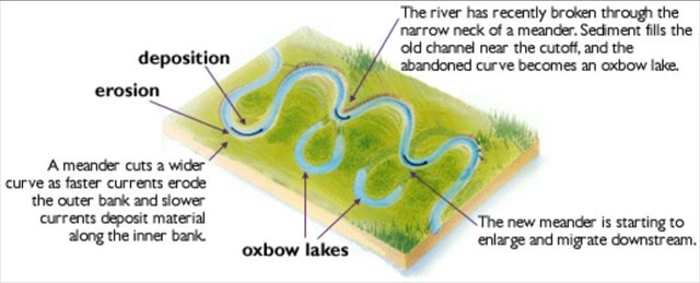
A szabad meanderek a középső és alsó folyók árterében alakulnak ki, ahol a víz áramlási sebessége lelassul, és az uszadékanyag leülepszik. A szabad kanyarulatokat a változékonyság jellemzi, a folyó folyamatosan változtatja a folyását, még az emberi élet léptékével mérve is lassú ütemben. A szabad meanderek fokozatosan mozognak az áramlás iránya mentén. Ez annak köszönhető, hogy az oldalirányú eróziónak leginkább kitett partok nem az ív csúcsán, hanem valamivel lejjebb vannak. Ily módon nemcsak a meanderek mozognak, hanem a meander nyakát is át lehet vágni. Az elhagyott meanderek zsákutcákká és holtkarokká válnak.
Az ékelt meanderek, más néven beékelődött meanderek ott fordulnak elő, ahol a folyó völgyeket képez a kemény kőzetben. Az ilyen helyeken a folyó nem tudja könnyen elmozdítani a csatornáját, hanem egyre mélyebbre és mélyebbre vágódik. Csak jóval hosszabb idő elteltével következhet be a nyak erodálódása és áttörése, akár egy meanderben is.
🇬🇧 In the middle and lower reaches, the river often flows through soft bedrock. Such a meander is created by scouring the bank on one side of the river and, conversely, settling on the other. Once the river has scoured the edge of the bank and hit a rock, for example, it can no longer scour the bank in that direction. The current bounces off the stone and begins to scour the other bank. The river thus becomes more and more tortuous every year. Eventually, however, the meander is so large that the river once again makes its way straight through, creating a dead-end.
Free meanders form in the floodplains of the middle and lower reaches of rivers where the velocity of the water flow slows and drift material is deposited. Free meanders are characterised by their variability, with the river constantly shifting its course at a slow pace, even on the scale of human life. Free meanders move gradually along the direction of flow. This is due to the fact that the banks most exposed to lateral erosion are not at the apex of an arc, but some distance downstream. In this way, not only do meanders shift, but the neck of the meander can be cut. Abandoned meanders become dead ends and dead arms.
Stuck meanders, also known as wedged meanders, occur where the river forms valleys in hard rock. In such places the river cannot easily move its channel and instead cuts deeper and deeper. It is only over a much longer period of time that the neck can be eroded and breached, even in a meander.
River bank types
🇭🇺 A kanyargó folyók gyors és lassú folyású helyeket váltogatnak. Mély medencék és merőleges falak alakulnak ki a hullámzó partokon, ahol a víz anyagot távolít el. Az ellenkező parton, lassabban áramló folyónál az anyag lerakódik, és gátak alakulnak ki. Az áramlás dinamikája nemcsak a függőleges tengelyének változásában nyilvánult meg, hanem a vízszintes tengelyében is, az áramlás oldalirányú elmozdulásával. A csatorna változásával és a kanyarulatok kiszélesedésével nagyobb és kisebb rönkök vagy akár egész fák kerültek a folyókba, amelyek akadályokat képeztek az áramlásban, és az áramlás erejét az ellenkező partra irányították, gyakran új kanyarulat kialakulásának alapjául szolgálva.
A folyópart és a folyóparti part két különböző típusú part, amelyek a meanderek közelében fordulnak elő. Ezek alapvető szerepet játszanak a folyók üledékképződési folyamatában.
Az alluviális part, más néven alluviális terasz, elsősorban az üledéknek a vízfolyás partján történő lerakódásával jön létre. Ezeket az üledékeket a víz áramlása szállítja, és az áramlási sebesség csökkenésekor rakódnak le a parton. Ez a típusú part általában széles és fokozatos lejtésű. Gyakori azokon a helyeken, ahol az áramlási sebesség csökken, és az üledék lerakódására hajlamos.
Ezzel szemben a partfal olyan part, amely a vízáramlás által erős eróziónak van kitéve, különösen a kanyarulatban. Ezek a partok jellemzően meredekek, és gyakran sziklás vagy meredeken lejtő felülettel rendelkeznek. A víz erősen befolyásolja e part alakját, és a későbbi erózió a part menti partról a vízbe hordja az anyagot, ahol az később az alluviális partra ülepedik.
🇬🇧 Meandering rivers alternate between places with fast and slow flow. Deep pools and perpendicular walls are formed on surging banks where water removes material. On the opposite bank, as the river flows more slowly, material is deposited and embankments form. The dynamics of the flow were not only manifested by changes in its vertical axis, but also in its horizontal axis, with the flow shifting sideways. As the channel changed course and meanders widened, larger and smaller logs or even whole trees entered the rivers, forming obstacles in the flows and directing the force of the current to the opposite bank, often providing the basis for the formation of a new meander.
A riprap bank and a rip-rap bank are two distinct types of banks that occur near meanders. They play an essential role in the process of river sedimentation.
The alluvial bank, also referred to as the alluvial terrace, is formed primarily by the deposition of sediment on the bank of a watercourse. These sediments are carried by the flow of water and deposited on the bank when the flow velocity decreases. This type of bank is usually wide and has a gradual slope. It is common in places where flow velocity decreases and sediment tends to be deposited.
Conversely, a surge bank is a bank that is subject to severe erosion by water flow, especially in a meander. These banks are typically steep and often have a rocky or steeply sloping surface. Water strongly influences the shape of this bank, and subsequent erosion carries material from the riparian bank into the water where it subsequently sediments on the alluvial bank.
Danube
🇭🇺 A Duna a második leghosszabb folyó Európában a Volga után. A Római Birodalom idején Hister néven ismerték, és sokáig a birodalom határát képezte. Ma tíz országon halad át, ami több, mint bármely más folyó esetében a világon. Németországban ered, majd délkelet felé folyik 2850 km hosszan, és áthalad vagy határolja Ausztriát, Szlovákiát, Magyarországot, Horvátországot, Szerbiát, Romániát, Bulgáriát, Moldovát és Ukrajnát, mielőtt a Fekete-tengerbe ömlik. Vízgyűjtő területe további kilenc országra is kiterjed.
A Duna vízgyűjtő területe olyan halfajoknak ad otthont, mint a csuka, a süllő, a menyhal, a harcsa, az angolna és a compó. Emellett nagy változatosságban élnek itt pontyfélék és tokfélék, valamint lazacok és pisztrángok is.
Ősidők óta a Duna hagyományos kereskedelmi útvonalként szolgál Európában. Ma teljes hosszából 2415 km hajózható. A folyó emellett fontos vízenergia- és ivóvízforrás is.
🇬🇧 The Danube is the second longest river in Europe after Volga. Known as Hister during the Roman Empire, the Danube was once a long-standing frontier of the empire, and today flows through 10 countries, more than any other river in the world. Originating in Germany, the Danube flows southeast for 2,850 km (1,770 mi), passing through or bordering Austria, Slovakia, Hungary, Croatia, Serbia, Romania, Bulgaria, Moldova and Ukraine before draining into the Black Sea. Its drainage basin extends into nine more countries.
The Danube river basin is home to fish species such as pike, zander, huchen, Wels catfish, burbot and tench. It is also home to a large diversity of carp and sturgeon, as well as salmon and trout.
Since ancient times, the Danube has become a traditional trade route in Europe. Today, 2,415 km (1,501 mi) of its total length are navigable. The river is also an important source of hydropower and drinking water.
🇭🇺 A "found it" naplóhoz kérem küldje el nekem a válaszokat a profilomon keresztül:
1) Magyarázza el a kanyarulatok típusait. Melyik típussal találkozunk itt a Dunán? Indokolja az állítását. 2) WP 01 Határozza meg, hogy Ön szerint milyen típusú bankról van szó, és miért. 3)A 02-es és 03-as WP-n készítsen fényképet a helyszínről, és ábrázolja, hol folyik a patak, és hol fog folyni a folyó a jövőben (ha szabadon vándorolhat). Küldje el nekem a képeket a válaszaival együtt. 4) Készítsen képeket magáról vagy a GPS-éről mindhárom útponton, és csatolja a fényképeket a logójához.
🇬🇧 For log as "found it" please send me answers for those questions via my profile:
1) Explain the types of meanders. Which type do we encounter here on the Danube? Justify your statement. 2) WP 01 Identify what type of bank you think it is and why. 3) On WP 02 and 03, take a photo of the site and plot where the stream runs and where the river is likely to flow in the future (if it could wander freely). Send the photos to me with your answers.
4) Take pictures of yourself or your GPS on all three waypoints (WP 01, WP 02, WP 03) and attach the photos to your log.
🇭🇺 A válaszok elküldése után azonnal jelentkezzen be, köszönöm.
🇬🇧 Please log the cache immediately after sending your answers, thanks. Photos by DanielKotmel, 2024. Sources -
Meander [online]. Available from https://www.britannica.com/science/meander-river-system-component
Fluvial features [online]. Available from https://www.nps.gov/articles/
meandering-stream.htm
Stream bank [online]. Available from https://www.lakesuperiorstreams.org/
understanding/streambank.htm

|