Logging Tasks
1. What does the first word in the title of this EarthCache mean?
2. Provide two observations of characteristics of braided rivers present in this area that support the statement that this section of the North Saskatchewan River is braided.
3. What do you think would happen to the braid bar due north from ground zero if the water discharge velocity of the North Saskatchewan River were doubled?
4. Please take a photo of yourself with the North Saskatchewan River in the background. You do not need to show your face. Alternatively, a photo of a personal item, such as your GPS or a piece of paper with your geocaching name and the date, with the North Saskatchewan River in the background is also acceptable.
Please send me this information through a Geocaching message and NOT in your log. Any logs containing the answers to my questions will be deleted.
Introduction
This EarthCache is a tribute to one of my favourite Earthcaches, Kisiskāciwani-sīpiy (GC40CEX) by Nell and Trav. It was archived due to owner inactivity. I still wanted people to see the beauty of this area and learn some of the geology lessons it has to offer, so I figured I'd place a new EarthCache here!
Note that the geology lessons that this EarthCache centers around are different than the previous EarthCache, so any finders of that cache must revisit this site and complete the new logging tasks to log this new cache.
This EarthCache can be found when driving northbound to North Battleford as there is a “Point of Interest” sign approximately 1 km prior to the turnoff to ground zero, which is at a publicly accessible scenic outlook. Ground zero is also accessible when driving southbound to Saskatoon as there is a crossing at Range Road 3081.
The Saskatchewan River, South Saskatchewan River, and North Saskatchewan River
Did you know that the province of Saskatchewan derives its name from the North Saskatchewan River? The Plains Cree name for the river is kisiskāciwani-sīpiy, which means “swift-flowing river” [1].
The Saskatchewan River (approximately 550 km long) is formed by the confluence of the North Saskatchewan River and the South Saskatchewan River (known as the Saskatchewan River Forks) just east of Prince Albert, Saskatchewan. The Saskatchewan River flows eastward over the Saskatchewan-Manitoba border and empties into Lake Winnipeg [2].
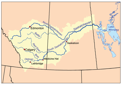
Saskatchewan River Drainage Basin [3]
The South Saskatchewan River is approximately 1,392 km long and is formed by the confluence of the Bow River and Oldman River in Alberta (west of Medicine Hat), winding its way eastward through Alberta and Saskatchewan before ending at the Saskatchewan River Forks. The source of the Bow River and Oldman River, which feed the South Saskatchewan River, is the eastern slopes of the Rocky Mountains [4].
The North Saskatchewan River (our river of interest for this EarthCache) is approximately 1,287 km long. It begins at the Saskatchewan Glacier in Banff National Park in Alberta, which is in the Rocky Mountains. It winds its way eastward from there through Alberta and Saskatchewan before ending at the Saskatchewan River Forks [5].
Braided Rivers
This section of the North Saskatchewan River is braided. Braided rivers are a type of river that form a network of many branches within a channel. The branches are separated by small and often temporary islands called braid bars. The braid bars are what make braided rivers braided.
Braided rivers are characterized by high bedload sediment (i.e., the sediment is transported along the stream bed rather than closer to the surface of the water because the sediment particles are too heavy to be suspended by the turbulent action of the flow [6]). The high bedload sediment helps in the development of braid bars. They are also characterized by varied flow speeds (present in this area because of the braid bars and varied river depth) and steep gradients (i.e., the slopes of the river). The gradients are steep due to the deposition of sediment.
Additionally, braid bars will migrate downriver over time, a process called bar migration. The upstream sides of the braid bars erode over time because they block the flow of the river. The downstream sides of the braid bars promote areas of low flow and eddies where sediment will deposit. Essentially, the braid bars get worn down upstream and are built up downstream, and the cycle continues as the river flows [7].
Logging Tasks (Again)
1. What does the first word in the title of this EarthCache mean?
2. Provide two observations of characteristics of braided rivers present in this area that support the statement that this section of the North Saskatchewan River is braided.
3. What do you think would happen to the braid bar due north from ground zero if the water discharge velocity of the North Saskatchewan River were doubled?
4. Please take a photo of yourself with the North Saskatchewan River in the background. You do not need to show your face. Alternatively, a photo of a personal item, such as your GPS or a piece of paper with your geocaching name and the date, with the North Saskatchewan River in the background is also acceptable.
Please send me this information through a Geocaching message and NOT in your log. Any logs containing the answers to my questions will be deleted.
A special thanks to AllThingsEarthCache and his series of YouTube videos that made it really easy to understand what a good Earthcache looks like.
References
[1] itwêwina (2024). “kisiskâciwani-sîpiy”. https://itwewina.altlab.app/word/kisisk%C3%A2ciwani-s%C3%AEpiy/
[2] Wikipedia (2024). “Saskatchewan River”. https://en.wikipedia.org/wiki/Saskatchewan_River
[3] Musser, K. (n.d.). “Saskatchewan River Drainage Basin”. Wikimedia Commons. https://commons.wikimedia.org/wiki/Category:Drainage_basin_maps_of_Canada#/media/File:Saskatchewanrivermap.png
[4] Newton, B. (2017). “South Saskatchewan River”. The Canadian Encyclopedia. https://www.thecanadianencyclopedia.ca/en/article/south-saskatchewan-river
[5] Newton, B. (2017). “North Saskatchewan River”. The Canadian Encyclopedia. https://www.thecanadianencyclopedia.ca/en/article/north-saskatchewan-river
[6] Stein, R. A. (1968). “Bed load”. In Geomorphology: Encyclopedia of Earth Science. Springer. https://doi.org/10.1007/3-540-31060-6_32
[7] Pang, A. (2017). “Braided Rivers”. GEL 109: Sediments and Strata (Sumner). https://geo.libretexts.org/Courses/University_of_California_Davis/GEL_109%3A_Sediments_and_Strata_(Sumner)/Textbook_Construction/Braided_Rivers