
Meenogahane - Coastal Geology
The coastal environment of the Meenoganhane has a big variety of landscapes with a different shapes and sizes.
The landscapes along the coast are the result of combined processes upon the rocks and sediments in these coastal zones. The most important processes includes the power of waves and tides of the sea, which developed the current shapes over a period from hundreds to thousends of years.
Mainly, the following structures can be found at the Meenoganhane:
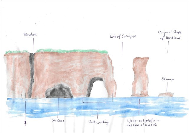
- SEA CAVE: The sea erodes and expands cracks in the base of the cliffs. The compression of the water and hydraulic actions are forming SEA CAVES. (see The Cave Eisc Chaol)
- BLOWHOLE: If a SEA CAVE grows land- and upwards into a vertical shaft by the compression of water pressed into the cave by waves and tidals a BLOWHOLE is formed. (see Poll á Tairbh)
- SEA ARCHE: If a cave is continuously eroded and expanded by waves and tides, sometimes it cuts through a headland. The result is a SEA ARCH. (see The Needles or The Window)
- SEA STACK: If a SEA ARCH is further eroded and widened, the surrounding rock becoes too weak and the arch collapses into the sea and the remainings of the rock are called SEA STACK. (see The Horrigles)
- SEA STUMP: When a SEA STACK erodes furthermore until it is just above the sea level, it is called a SEA STUMP. (see The Grey Island)
TO LOG THIS EARTHCACHE
please send me an e-mail through my profile with the answers of the following questions:
1. Which landscape structure can you see when you take a look from the information board over the sea? Is the structure named on the board?
2. Which words are missing in the picture above?
3. What is the the name of the Dublin-born geologist and naturalist which examined the area first?
4. What are "Kerry Diamonds"?
5. Take a photo of yourself or with a paper which shows your Cacher name at the pier. Do not spoil the answer to the first question. Post the photo in your log.
You're allowed to log directly after sending me the mail, if there are problems with the answers, I'll contact you!