Edit 31 mars 2025 :
Un arrêté préfectoral bloque l'accès au sentier des roches.
En attendant de voir si cette interdiction est pérenne ou pas, une photo devant le panneau d'interdiction suffit pour valider cette cache
Rappel concernant les « Earthcaches »
ATTENTION, il n'y a pas de conteneur à rechercher ni de logbook à renseigner. Il suffit de se rendre sur les lieux d'observations puis de réaliser les conditions de validation ci-dessous.
Une Earthcache ayant comme objectif de mettre en pratique une leçon de géologie par des observations de terrain, il est conseillé de lire le descriptif afin de vous aider à répondre aux questions.
Questions pour valider la cache géologique
- Question 0 : Prenez une photo de vous ou votre pseudo sur le sentier des Roches.
Cette photo devra au choix nous être transmise avec les réponses ou être ajoutée à votre log.
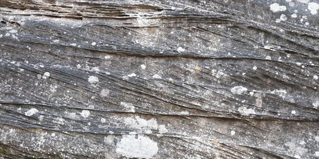
Vous cheminez en montant le Sentier des Roches jusqu'à atteindre un grand affleurement de roche sur la droite (photo WP1).
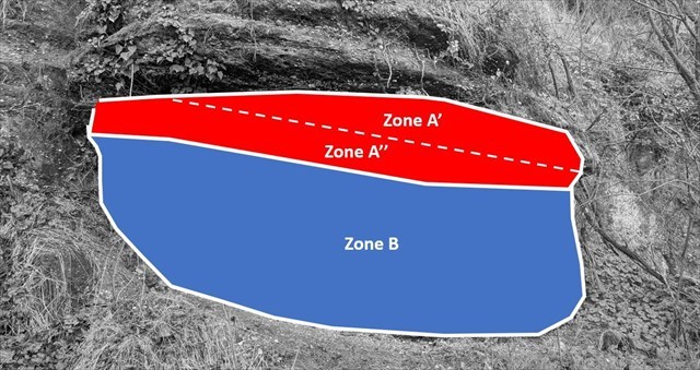
- Question 1 : Décrivez globalement l'affleurement devant vous et déduisez en de quelle partie de la formation du Trias de l'éperon de Mutzig il s'agit.
- Question 2 : Comparez les inclinaisons des deux parties A' et A'' de la zone rouge A et expliquez avec vos propres mots comment cette disposition s'est mise en place.
- Question 3 : A l'aide de la classification granulométrique, déterminez la nature de formation sédimentaire détritique formant la zone B. Les sédiments ont-ils été déposés par un fleuve ou par un glacier ? Justifiez votre réponse.
Vous pouvez vous loguer sans attendre notre confirmation,
mais vous devez nous envoyer les réponses en même temps soit par mail via notre profil (
fafahakkai), soit via la messagerie geocaching.com (Message Center).
S'il y a des problèmes avec vos réponses nous vous en ferons part.
Les logs enregistrés sans réponse seront supprimés.
Et en théorie, cela donne quoi ?
► Contexte géologique local
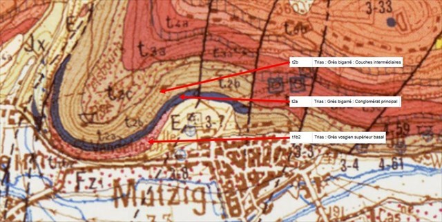
Mutzig est une des portes d'entrée côté Alsacien des Vosges du Nord.
Elle est surplombée par un imposant éperon d'une roche formée au Trias, des roches sédimentaires gréseuses allant d'un grès vosgien rose (t1b2) à un grès à Voltzia (t2b) en passant par un formation conglomératique particulier appelé Conglomérat Principal (t2a).
► Une roche, des roches au Trias
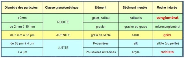
Les différentes formations de la région sont des dépôts sédimentaires détritiques mis en place il y a 250 millions d'année.
Issus de l'érosion de chaînes de montagnes hercyniennes, ces sédiments sont de taille variable (argile à cailloutis).
Une fois cimentés par diagenèse, ces dépôts donnent différentes roches dépendant de la taille de ces sédiments (classification granulométrique).
Au niveau des hauteurs de Mutzig se succèdent 3 formations sédimentaires :
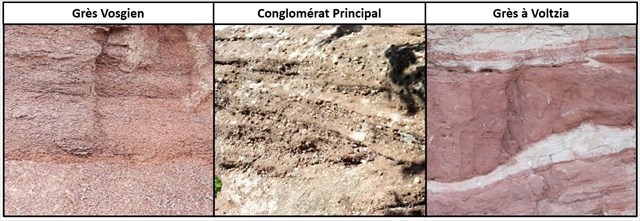
- Le Grès Vosgien : roche de couleur rose aux grains grossiers (taille millimétrique), il s'agit d'une arénite grossière de couleur rose, à faible teneur en argiles et au litage peu marqué.
- Le Conglomérat Principal : il est constitué d'une succession irrégulière de conglomérats et de bancs de grès rose. Il existe deux types de conglomérats :
- les brèches dont les éléments sont anguleux et souvent issus d'un charriage glaciaire.
- les poudingues, si les éléments sont arrondis, roulés (= galets) issus d'une origine fluviale.
Dans le Conglomérat Principal, les galets sont très arrondis, mesurent quelques centimètres et sont principalement faits de quartz (roche cristalline opaque blanche et très dure).
- Les Grès à Voltzia (ou grès à Meules) sont de couleur variée (rose à violet) aux grains fins. Ils sont riches en argiles avec une stratification plus marqué.
► Des chenaux fluviatiles aux lits de sédiments vosgiens
En coupe verticale, ces roches sédimentaires du Trias présente une disposition séquentielle, avec une stratification (appelé aussi litage) le plus souvent oblique ou entrecroisée.
Cette stratification particulière est la trace fossile du milieu dans lesquels les sédiments se sont déposés, une immense plaine deltaïque où des vastes cours d'eau divaguant érodaient ou déposaient leurs alluvions dans de larges chenaux.
Avec le courant les particules de sable sont transportées de l’arrière à l’avant d'un banc de sable et avec la gravité ils retombent à l’avant de l'ensemble. Ce banc se développe par petites couches au niveau de l'aval, formant des couches obliques par rapport au lit du fleuve.
En fonction du courant, du sens de la pente, les dépôts de sable vont changer d'inclinaison et se chevaucher les uns sur les autres, donnant un ensemble de litages entrecroisés.
A reminder about Earthcaches
ATTENTION, there is no container to look for or logbook to fill in. All you have to do is go to the observation sites and complete the validation conditions below.
As the aim of a geology cache is to put a geology lesson into practice by making observations in the field, you are advised to read the description to help you answer the questions.
Questions to validate the Earthcache
- Question 0 : Take a photo of yourself or your pseudonym along the Stones Trail.
This photo can either be sent to us with your answers or added to your log.
You are walking up the Sentier des Roches until you reach a large rock outcrop on the right (photo WP1).
- Question 1 : Give an overall description of the outcrop in front of you and deduce which part of the Triassic formation of the Mutzig spur it is.
- Question 2: Compare the inclinations of the two parts A‘ and A’' of the red zone A and explain in your own words how this arrangement came about.
- Question 3: Using the particle size classification, determine the nature of the detritic sedimentary formation forming zone B. Were the sediments deposited by a river or a glacier? Justify your answer.
You can log this cache without waiting for our confirmation,
but you must send us the answers at the same time, by e-mail via our profile (
fafahakkai) or by the system of Message Center of geocaching.com.
If there is a problem with your answers we will notify you.
The logs recorded without answers will be deleted.
What does this mean in theory?
► Local geological context
Mutzig is one of the Alsatian gateways to the Northern Vosges.
It is overlooked by an imposing spur of rock formed in the Triassic period, sandstone sedimentary rocks ranging from pink Vosges sandstone (t1b2) to Voltzia sandstone (t2b) via a particular conglomeratic formation called Conglomérat Principal (t2a).
► A rock, some rocks in the Triassic period
The various formations in the region are detrital sedimentary deposits laid down 250 million years ago.
Resulting from the erosion of Hercynian mountain ranges, these sediments vary in size from clay to pebbles.
Once cemented by diagenesis, these deposits give different rocks depending on the size of the sediment (granulometric classification).
There are 3 sedimentary formations on the heights of Mutzig:
- Vosges Sandstone: a pink-coloured rock with coarse grains (millimetre-sized), this is a coarse pink arenite with a low clay content and a shallow bedding.
- The Main Conglomerate: this is made up of an irregular succession of conglomerates and banks of pink sandstone. There are two types of conglomerate:
- Breccias, with angular elements often resulting from glacial drifting.
- Poudingues, with rounded, rolled elements (= pebbles) of fluvial origin.
In the Main Conglomerate, the pebbles are very rounded, a few centimetres in size and mainly made of quartz (a very hard, white opaque crystalline rock).
- The Voltzia Sandstone (or Grindstone) is fine-grained and varies in colour from pink to violet. They are rich in clay with a more marked stratification.
► From river channels to Vosges sediment beds
In vertical section, these Triassic sedimentary rocks have a sequential layout, with stratification (also known as bedding) that is usually oblique or criss-crossed.
This particular stratification is the fossil trace of the environment in which the sediments were deposited, an immense deltaic plain where vast, raging rivers eroded or deposited their alluvial deposits in wide channels.
With the current, sand particles are transported from the back to the front of a sandbank and with gravity they fall back to the front of the whole. The sandbank develops in small layers downstream, forming oblique layers in relation to the river bed.
Depending on the current and the direction of the slope, the sand deposits will change slope and overlap one another, creating a series of criss-crossing beds.
► Sources bibliographiques / Bibliographical sources