Congaree National Park is located in central South Carolina and protects the largest intact expanse of old-growth bottomland hardwood forest in the United States. This unique ecosystem thrives along the Congaree River and offers a rare glimpse into a biodiverse floodplain where towering trees form a natural canopy. Seasonal flooding replenishes the soil and supports habitats for various plant and animal species.
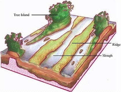
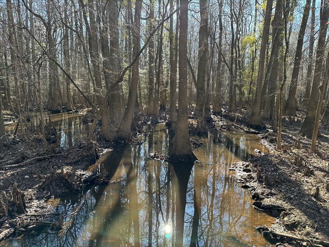
Two important features found in Congaree National Park are guts and sloughs, each having unique characteristics and roles. Guts are narrow, ephemeral channels that form in floodplains and wetlands, serving as critical conduits for water flow during flooding events. These channels develop in areas where floodwaters concentrate and carve temporary paths through soft sediment. They are typically the first sites to convey flowing water during a flood and the last to dry out as waters recede. Guts can often be identified by their defined, linear shapes and the presence of exposed sediment or sparse vegetation, which is a result of their periodic flow. They are vital for distributing water and sediment across the floodplain, replenishing nutrients and maintaining the dynamic balance of wetland ecosystems.
In contrast, sloughs are broader, swampy depressions that often form from abandoned river channels, creating low-lying areas where water stagnates and accumulates. These features retain water for extended periods, allowing fine sediments and organic material to settle, enriching the surrounding environment. Their formation is closely linked to changes in river dynamics, such as channel migration and sediment deposition. Unlike guts, which are typically flowing, sloughs contain standing water. By holding water and nutrients, sloughs act as natural reservoirs, influencing hydrology and providing critical habitats for wetland species.
Logging Requirements:
- Describe the feature in front of you (height, width, amount of water...etc). Based on your observations and the description, would you classify it as a gut or a slough? Explain your answer.
- How do you think this feature will change over time? Explain.
- Upload a photo taken along the Boardwalk Trail near the posted coordinates. You don't have to be in the photo, though it is strongly encouraged.
Sources:
- https://npshistory.com/publications/cong/brochures/self-guided-tour-2013.pdf
- https://www.govinfo.gov/content/pkg/GOVPUB-I29-PURL-gpo128601/pdf/GOVPUB-I29-PURL-gpo128601.pdf