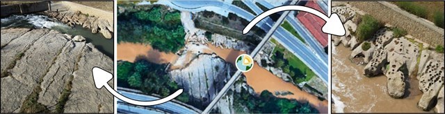
El Pont Vell de Manresa, aixecat sobre el riu Cardener, es troba a
l'entrada de la ciutat. És un pont romànic de vuit arcs de mig punt. El
riu Cardener delimita pel sud el nucli urbà de Manresa i
exposa les roques grises d’origen marí.
Si us situeu al punt mig del pont, a uns 25 metres sobre el nivell del
llit del riu, podreu observar les dues ribes del riu a banda i banda.
La riba nord sembla un formatge emmental,
està recoberta de forats!
Si voleu saber l’origen d’aquests
forats excavats a la roca aquest és el vostre EarthCache, ja que com
tot, aquests forats també tenen la seva explicació.
PER VALIDAR AQUEST EARTHCACHE:
Us
podeu apropar a les cadolles, la zona inferior es accessible baixant
per la part sud del pont, vigileu sempre la corrent del riu abans de
baixar.
1.-
Feu-vos una foto (on sortiu vosaltres
o el nom del vostre equip) on es vegi el cartell MANRESA♥️ i el
Pont Vell al fons. Pugeu-la en el vostre registre online o
envieu-la amb
les respostes sinó la voleu publicar.
2.- Entre totes les cadolles,
observes
alguna marmita de gegant? Què diferencia una cadolla d’una marmita de
gegant?
3.-
Gràcies a quins processos
geològics externs es formen les cadolles?
a) Erosió + Sedimentació
b) Erosió + Transport
c) Erosió + Diagènesi
d) Erosió + Meteorització
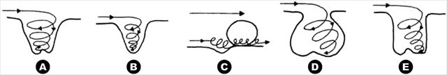
4.-
Ordena les següents fases de la
formació d’una cadolla o marmita de gegant, seguint la seva
evolució morfològica en el temps amb el model de remolí hidràulic. (ex:
ABCDE)
Heu d'enviar les respostes (en català, castellà o anglès). No cal
esperar la meva resposta per fer el registre online.
Espero que gaudiu de la vista des del
Pont Vell, aprenent una mica més sobre les cadolles i els efectes de
l’erosió del riu sobre la roca calcària.
FORMES EROSIVES DEL RIU CARDENER SOTA EL
PONT VELL
El Pont Vell de Manresa es fonamenta en un
estrat de roca calcària nummulítica especialment resistent. Aquesta
capa de calcària d’origen marí s’inclina lleugerament cap al nord
seguint el cabussament general de la formació geològica, de manera que
aflora en major extensió a la riba sud, on queda més amunt.
L’aflorament de calcària a la riba sud
del Pont Vell destaca també per la seva sèrie d’esquerdes paral·leles
al pendent. El propi pes de la roca ha de ser responsable
d’aquesta xarxa geomètrica de fractures.
A la riba nord la poca extensió descoberta
de calcària queda sovint sota l’aigua del riu; per això és precisament
a aquest costat on s’han format aquests forats o “cadolles”, objecte
d’aquest Earthcache.
Des de la barana del pont podem
veure
els efectes de l'erosió de l'aigua sobre la roca calcària de la llera
del riu, amb fractures paral·leles a la riba sud i cadolles a la riba
nord.
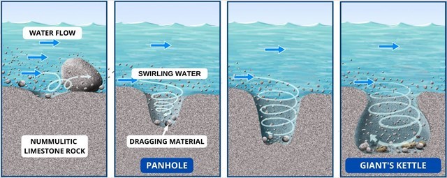
COM ES FORMEN LES CADOLLES?
A les esplanades de roca dura exposada
de les lleres de rius i rieres, sovint s’observen uns curiosos forats
circulars, d’origen natural, del voltant d’un pam de diàmetre i una
mica menys de fondària, anomenats “cadolles”. Les cadolles es troben
sobretot en roca calcària i sempre ben a la vora de l’aigua circulant.
Les cadolles són cavitats erosives a les lleres dels rius que es
generen per l'acció dels corrents fluvials,
es formen per abrasió, per l’acció erosiva
de la sorra arrossegada pel corrent turbulent de les riuades, girant
contínuament i amb força en una cavitat. Una irregularitat inicial a la
roca pot desencadenar la generació d’una cadolla.
Els fragments o materials erosius han
de tenir una duresa semblant o més gran que la de la roca en què es
genera la cavitat, per la qual cosa generalment es tracta de
fragments erosionats de la pròpia roca.
Aquests colpegen contra les vores del forat
inicial i van arrodonint i fent més profunda la cavitat.
Si els forats a la roca són molt més grans, de la mida d’una banyera,
s’anomenen “
marmites de gegant”.
Les marmites de gegant es formen al bell mig del curs d’un torrent o a
la capçalera d’una riera per la mateixa acció abrasiva però més
constant i a una escala major, sumant grava a la sorra.
Sovint les cadolles mantenen l’aigua
de la pluja o de la darrera crescuda del riu o riera. Un cop
retinguda l'aigua, comencen a actuar processos de
meteorització química que ajuden a
fer més profunda i ampla la irregularitat/cadolla existent. Aquesta
situació genera un sistema de realimentació, ja que com més gran és la
cadolla més aigua és retinguda i per tant, hi haurà més meteorització
química.
El diòxid de carboni atmosfèric es combina amb l’aigua de pluja per
formar àcid carbònic. (H2O + CO2 > H2CO3). L'aigua es torna més
àcida a mesura que travessa el terra i la vegetació. Les calcàries
(carbonat de calci) reaccionen amb l'aigua de pluja àcida (àcid
carbònic, H2CO3), per formar hidrogen carbonat de calci. (H2CO3 + CaCO3
> Ca(HCO3)2).
El terme
“meteorització” té un significat precís, només fa referència a la
destrucció in situ de les roques i no inclou la retirada dels fragments
formats (això s’anomena “erosió”).
LA ROCA CALCÀRIA NUMMULÍTICA
Les calcàries són roques carbonàtiques
formades majoritàriament per carbonat de calci. Els tipus de
calcàries que més abunden al Bages formen capes molt resistents a
l’erosió i poden tenir un
origen marí
o lacustre. Són explotades com a material de construcció i
antigament s’havien utilitzat per fer calç. Les calcàries marines
bagenques presenten una gran quantitat de macrofòssils i van lligades a
la presència d’esculls de corall.
La calcària nummulítica és el tipus de
roca calcària constituïda per una acumulació d’esquelets o conquilles
fòssils de nummulits, de natura calcària, fermament adherits per una
matriu de ciment igualment calcari. La calcària nummulítica és molt
característica de l’època de l’Eocè, al període Terciari.
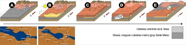
CONTEXT GEOLÒGIC DE L’ENTORN
A
continuació trobareu una mica de
context de l’evolució geològica de l’entorn on us trobeu, per entendre
d’on provenen les roques calcàries en que s’han format aquestes
cadolles. Roques calcàries nummulítiques/coral·lines de la formació
Tossa.
Les roques del Bages no són especialment antigues des del punt de vista
geològic. La majoria es van formar durant el període Terciari. Quan es
van començar a sedimentar els materials que avui constitueixen les
roques visibles de la comarca ja havien passat uns 23 milions d’anys
des de l'extinció dels dinosaures, però encara faltaven uns 37 milions
d’anys per a l’aparició dels primers homínids.
La història geològica del Bages s’inicia en l’època en què es van
dipositar els materials que formen les roques més antigues que afloren
a la zona:
A. Fa entre 42 i 35 milions d’anys
(Eocè mitjà) el Bages estava ocupat per un
braç de mar que inicialment formava part d’un gran golf comunicat amb
l’oceà Atlàntic. En aquest mar poc profund s’hi acumulaven els
sediments fangosos i sorrencs que més endavant van passar a formar part
del subsol bagenc. Al sud de la comarca, hi havia la línia de
costa. Els esculls de corall, amb una fauna molt variada, ocupaven les
zones properes a la costa d’aquell mar càlid.
B. Fa al voltant de 35 milions d’anys
(Eocè superior) el mar es va anar
restringint fins a assecar-se, cosa que va comportar la
precipitació d’un bon gruix d’evaporites (sal gemma, potasses i guix) a
la part més interna de la conca.
C. Des de fa uns 35 milions d’anys fins ben entrat
l’Oligocè, el Bages va formar part d’una conca continental amb cursos
fluvials que deixaven una important sedimentació terrígena i
llacs on es formaven calcàries. La
sedimentació terrígena va donar lloc a les roques detrítiques rogenques
(bàsicament lutites i sorrenques) que caracteritzen els sectors
centreoccidental i septentrional de la comarca. Aquests materials
recobreixen les evaporites i els sediments marins dipositats abans.
D. Després de la sedimentació dels materials paleògens i
fins cap al Miocè mitjà (fa entre 16,4 i 11,2 milions d’anys), la
influència del plegament dels Pirineus va originar alguns plecs
anticlinals, sovint estrets i en part fallats, separats per amplis i
suaus sinclinals.
E. Des de fa, com a màxim, 13 milions d’anys (Miocè mitjà)
fins a l’actualitat hi ha hagut un intens
buidatge erosiu de la conca de l’Ebre que ha estat el principal
responsable de l’aspecte del relleu bagenc actual.
Al començament d’aquest interval, va desaparèixer la xarxa fluvial que
fluïa cap al fons de la depressió de l’Ebre i es va establir l’actual.
Això va ser degut a l’enfonsament del massís Català i a l’aixecament
simultani de la conca de l’Ebre, de la qual, en el sentit geològic del
terme, forma part el Bages.
La resistència desigual dels diferents estrats ha fet que l’erosió
modeli relleus ben destacats allà on la roca és coherent (difícil
d’erosionar), com és el cas de Montserrat, davant de zones deprimides,
amb predomini de materials fàcilment erosionables, com la de Sant
Vicenç de Castellet. La xarxa fluvial dels rius Llobregat i Cardener
constitueix el sistema de drenatge actual que continua l’evacuació dels
productes de l’erosió cap a la mar Mediterrània.
* * * * *
The Pont Vell de Manresa, raised
over the Cardener River, is at the entrance to the city. It is a
Romanesque bridge of eight semicircular arches. The Cardener River
delimits the urban center of Manresa to the south and exposes the gray rocks of marine origin.
If you stand at the midpoint of the bridge, about 25 meters above the
level of the riverbed, you can see both banks of the river on either
side. The north shore looks like
emmental cheese, it's covered in holes!
If you want to know the origin of
these holes dug in the rock, this is your EarthCache, because like
everything these holes also have their explanation.
TO VALIDATE THIS EARTHCACHE:
If you want, you can get closer to
the panholes, the lower area is accessible by going down the south side
of the bridge, always watch the current of the river before going down.
1.- Take a photo (with you or the
name of your team) where you can see the MANRESA♥️ sign and the Pont
Vell in the background. Upload it to your online registration
or send it with the answers if you don’t want to publish it.
2.- Among all the panholes, do you
see any giant kettle? What differentiates a panhole from a giant
panhole?
3.- What external geological
processes form the panholes?
a) Erosion + Sedimentation
b) Erosion + Transport
c) Erosion + Diagenesis
d) Erosion + Weathering
4.- Order the following phases of the
formation of a giant pot or marmite, following its morphological
evolution over time with the hydraulic whirlpool model. (ex: ABCDE)
I hope you enjoy the view from the Old
Bridge, learning a little more about the panholes and the effects of
river erosion on limestone.
EROSIVE FORMS OF THE CARDENER RIVER UNDER
THE OLD BRIDGE
The
Old Bridge of Manresa is based on a layer of especially resistant
nummulitic limestone rock. This layer of limestone of marine origin is
slightly inclined north following the general flow of the
geological formation, so it emerges
to a greater extent on the southern shore, where it is higher.
The limestone outcrop on the south
bank of the Old Bridge also stands out for its series of cracks
parallel to the slope. The weight of the rock itself must be
responsible for this geometric network of fractures. On the north bank the little discovered
extension of limestone is often under the water of the river; that is
why it is precisely on this side where these holes or panholes have
formed, object of this Earthcache.
From the bridge railing we can see
the effects of water erosion on the limestone rock of the riverbed,
with fractures parallel to the south bank and panholes on the north bank.
The panholes are erosive
cavities in the riverbeds that are generated by the action of the river
currents, are formed by abrasion, by
the erosive action of the sand dragged by the turbulent current of the
floods, turning continuously and forcefully in a cavity. An initial
irregularity in the rock can trigger the generation of a decipe.
The fragments or erosive materials
must have a hardness similar or greater than that of the rock in which
the cavity is generated, so it is usually eroded fragments of
the rock itself. These hit the edges
of the initial hole and round and deepen the cavity.
Often the panhole keep the water from
the rain or from the last flood of the river or stream. Once the
water has been retained, chemical
weathering processes begin to act that help to make the existing
irregularity/degree deeper and wider. This situation generates a
feedback system, since the larger the panhole, the more water is
retained and therefore, there will be more chemical weathering.
Atmospheric carbon dioxide is combined with rainwater to form carbon
dioxide. (H2O + CO2 > H2CO3). Water becomes more acidic as it
crosses the ground and vegetation. Limestones (calcium carbonate) react
with acidic rainwater (carbonic acid, H2CO3), to form calcium carbonate
hydrogen. (H2CO3 + CaCO3 > Ca(HCO3)2). The term “weathering” has a precise
meaning, only refers to the in situ destruction of the rocks and does
not include the removal of the fragments formed (this is called
“erosion”).
Limestones
are carbonatic rocks formed mostly by calcium carbonate. The
types of limestone that abound most in Bages form layers that are very
resistant to erosion and may have a marine
or lacustrine origin. They are exploited as construction
material and had formerly been used to make lime. The Bages marine
limestones have a large amount of macrofossils and are linked to the
presence of coral reefs.
Numulitic limestone is the type of
limestone formed by an accumulation of fossil skeletons or shells of
nummulites, of limestone nature, firmly attached by an equally
calcareous cement matrix. Numulitic limestone is very characteristic of
the Eocene epoch, in the Tertiary period.
GEOLOGICAL CONTEXT OF ENVIRONMENT
Below you will find some context of the geological evolution of the
environment where you are, to understand where the limestone rocks in
which these panholes have formed come from. Nummulithic/coralline
limestone rocks of the Tossa formation.
The rocks of Bages are not especially ancient from the geological point
of view. Most were formed during the Tertiary period. When the
materials that today constitute the visible rocks of the region began
to be sedimented, about 23 million years had passed since the
extinction of the dinosaurs, but there were still about 37 million
years left for the appearance of the first hominids.
A. Between 42 and 35 million years ago (Middle Eocene) Bages was
occupied by a sea arm that initially formed part of a large golf
connected to the Atlantic Ocean. In this shallow sea accumulated muddy
and sandy sediments that later became part of the subsoil Bagenc. To
the south of the region was the coastline. The coral reefs, with a
varied fauna, occupied the areas near the coast of that warm sea.
B. About 35 million years ago (Late Eocene) the sea was restricted to
drying, which led to the precipitation of a good thickness of
evaporites (gemma salt, potash and chalk) in the innermost part of the
basin.
C. From about 35 million years ago until well into the Oligocene, the
Bages was part of a continental basin with river courses that left an
important terrestrial sedimentation and lakes where limestones were
formed. The earthy sedimentation gave rise to the red detritic rocks
(basically lutite and sandy) that characterize the central-western and
northern sectors of the region. These materials cover the evaporites
and marine sediments deposited before.
D. After the sedimentation of the palaeogenous materials and even
towards the middle Miocene (between 16.4 and 11.2 million years ago),
the influence of the folding of the Pyrenees originated some anticline
folds, often narrow and partially failed, separated by wide and soft
stilts.
E. For a maximum of 13 million years (Middle Miocene) until today there
has been an intense erosive emptying of the Ebro basin that has been
the main responsible for the appearance of the current Bagenc relief.
At the beginning of this interval, the river network that flowed to the
bottom of the Ebro depression disappeared and the current one was
established. This was due to the collapse of the Catalan massif and the
simultaneous uprising of the Ebro basin, of which, in the geological
sense of the term, Bages is part.
The uneven resistance of the different strata has made erosion model
well-known reliefs where the rock is coherent (difficult to erode), as
is the case of Montserrat, in front of depressed areas, with a
predominance of easily eroded materials, such as that of Sant Vicenç de
Castellet. The river network of the Llobregat and Cardener rivers
constitutes the current drainage system that continues the evacuation
of the products of erosion towards the Mediterranean Sea.