Part of a series of multi's designed to help you explore some Christchurch suburbs. I'm working from the suburb boundaries in Google Maps, which I've come across in a number of other places.
Upper Riccarton
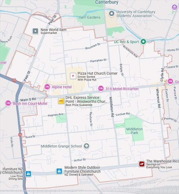
Map Data ©2025 (image from Google Maps)
Neighbouring suburbs: Ilam,
Riccarton,
Middleton, Sockburn.
Name origin: See Riccarton. At first the name Riccarton referred to the modern day suburbs of Riccarton and UpperRiccarton, and what is now Riccarton was referred to as Lower Riccarton.
The boundaries of Upper Riccarton are (roughly) the University of Canterbury to the north, Clyde and Wharenui Roads to the east, Blenheim Road to the south and Peer Street and Curletts Road to the west.
As with Riccarton, road links through the suburb (Riccarton Road and later Blenheim Road) were established soon after colonists arrived, but much of the suburb remained farmland for many decades. In 1850, surveyor Charles Torlesse marked the route of the first road leading to the Canterbury Plains. The starting point (marked by a plaque at WP3) is at the intersection of Riccartion, Yaldhurst and Main South Roads. This road was initially called Harewood Road (and today is called Yaldhurst Road). By the late 1850s the road only went as far as Riccarton Racecourse, and from there travellers had no formed road to follow across the Canterbury Plains.
A significant early business in the area was the Bush Inn (WP2), established in 1865 at the corner of Waimairi and Riccarton Roads. It was built there because it was on the main transport route between Christchurch and the plains, and was an important stop on the coach network that developed in the following decades. It has been popular with various groups over the years: stockmen driving stock from the plains to the saleyards, people from the RNZAF base at Wigram in the 20th century, university students from the Ilam campus from the 1970s. By the 1980s it had become a large suburban hotel, with lots of parking, a big lounge bar, Paddy's Grill restaurant and (I'm pretty sure) motor-hotel type accommodation. In the 1980s most of the Bush Inn complex was turned into a shopping centre, leaving just the oldest building on the corner of Riccarton and Waimairi roads. A section of the current Bush Inn building dates from the 1860s, though most of the building was built in the 1910s. When the Bush Inn Shopping Centre opened it featured a Woolworths supermarket, a Deka department store and eleven other outlets. The centre has had its ups and downs over the years, with key tenants coming and going.
The main schools in the suburb are Villa Maria, Middleton Grange and Kirkwood Intermediate. Villa Maria was established, by the Sisiters of Mercy in 1918. It was on the corner of Yaldhurst Road and Peer Street. At that time is must have been right on the outskirts of Christchurch, and mostly surrounded by farmland. The other schools date from the 1960s, and were part of the post-war conversion of farmland to housing areas. Some of the street name names in the area suggest they are part of post-war developments. Two examples are Hilary Crescent and Tensing Place. Another is Ballantyne Ave (the Ballantynes fire was in 1947).
The Feltex factory (WP1) opened in 1948, and was one of the first carpet factories in NZ. The area would have still been on the outskirts of the city, even though it was 30 years after Villa Maria was established (less than 1km south along Peer street). The factory closed in 2006 when a debt-laden Feltex went into receivership, having been sold via an IPO in 2004. The IPO and receivership were controversial, and the subject of much legal action (which came to an end in the supreme court in 2021). By the time the factory closed, the area was residential, and it was no surprise to see the factory site used for a supermarket and retirement village.
An interesting landmark building in the suburb is the former Rannerdale War Veterans Home in Hansons Lane (WP5). The original Rannerdale site was in Papanui. It was founded in 1921 to provide healthcare and support for Boer War and World War I veterans. Rannerdale moved to Hansons Lane in 1956 (another Upper Riccarton development in the post-wat period). The last residents moved out in 2022, and the building is now operated as student accommodation by Hansons Village Accommodation (74 rooms are available).
Futher south on Hansons Lane is the Chinese Consulate. China has had a consulate in Christchurch since 2011. I considered having a WP outside the consulate, but there's a lot of security cameras there, and I thought it best not to have cachers lurking outside the consulate.
The Sir John McKenzie Memorial Childrens Library (WP4) is another post-war building. In the 1950s a group of mothers wanted a library so their children had access to proper books (as an alternative to the many comics that appeared after the war). Initially the childrens library operated out of a room in the Upper Riccarton War Memorial Library, located on the other side of Riccarton Rd, opposite Hansons Lane. The War Memorial library opened in 1919 and was the first of seven war memorial libraries built in NZ (it was demolished in recent years, and there are plans to turn the site into a memorial gardens). Sir John Mckenzie founded Mckenzies department stores (in 1910). When Mckenzies was bought by L D Nathan and Company in 1980, it had grown to a chain of 70 stores (interestingly, the Mckenzies stores were rebrandard as Deka, the chain mentioned above). The initial link between childrens library and the Sir John Mckenzie was in the form of a number of grants to buy books given by the McKenzie charitable trust. Mckenzie died in 1955. NZ Rotary Clubs were made the main agents for allocating trust funds. Local rotary clubs initially investigated making a grant to the War Memorial library, but on realising a popular childrens library was operating out of a room in the war memorial library, the clubs decided to arrange building a Childrens library on the other side of Riccarton Road. The land was an unused part of a block of land developed for pensioner housing. The land was transferred to the local council (Paparoa County). The library was opened in 1958 by the governor general. In 1989 all of urban Christchurch came under Christchurch City Council, and the library became part of the CCC library system. The building now seems to be used by a toy library (not sure when the CCC stopped using it for library purposes).
The bulk of the modern suburb of Upper Riccarton is residential, and there is a big student population. Retail outlets are mainly found along Riccarton Road. A series of dated small shopping areas across Waimairi Road from the Bush Inn are home to a diverse range of Asian restaurants. Commercial premises in the suburb are mainly found along Blenheim Road. Middleton Park is the biggest park in the suburb. Other parks include Auburn Reserve, Hansons Reserve, Milnebank Reserve and Siska Reserve. A short section of Ilam Stream cuts through the North West of the suburb.
You will need visit five locations to work out where the cache is hidden.
Final: S 43 32.ABC E 172 35.DEF
- A = number of flagpoles you can see from the foot path in front of building at WP5 (Rannerdale).
- B = the sum is 2B of the 4 digits on the last line of the left hand panel of the sign at WP2 (Bush Inn).
- C = second digit of the six digits on the first line of plaque at WP3 (Road Survey Plaque).
- D = sixth digit of the six digits on the first line of plaque at WP3 (Road Survey Plaque).
- E = subtract 2 from the number of diamonds across the top of one of the two small rectangular hatch covers (with 2 letters on them) at WP1 (Feltex Factory).
- F = the number of letters in the second word on line 6 of the plaque on the brick wall at WP4 (Library).
Checksum of A to F: 12 (A to F are all single digit numbers).
Cache is a pill bottle hidden in a block of wood, tucked behind a fence post, on top of the bottom rail. Should be very easy to spot. If GZ is muggly you'll probably have to come back another time.