Skip to content

Paracentrotus lividus EarthCache

Hidden : 2/22/2026
Difficulty:
2.5 out of 5
Terrain:
2.5 out of 5

Size: Size:   other (other)

Join now to view geocache location details. It's free!

Watch

How Geocaching Works

Please note Use of geocaching.com services is subject to the terms and conditions in our disclaimer.

Geocache Description:


Perguntas para responder - questions to answer

Para reclamar esta EarthCache deverá enviar-me, através do meu perfil e antes de qualquer registo, as respostas às seguintes questões. Se algo estiver incorrecto será contactado. Não é necessário esperar por qualquer autorização. Por favor não envie fotografias. Essas são mais úteis no registo.

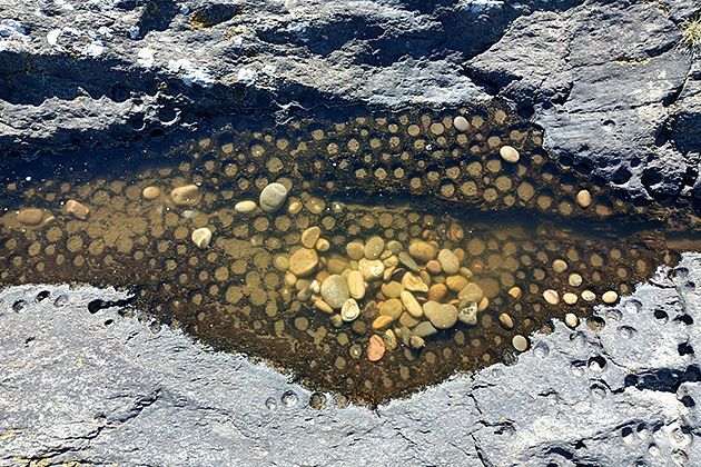
Nas coordenadas da EarthCache, e virado para o mar, aos seus pés há um losango em que se podem ver vários exemplares de icnofósseis (são os buracos). Nessa área é possível ver claramente um filão que divide a zona. Na extremidade do filão mais próxima do mar.

1 – Qual é o diâmetro do buraco mais próximo do mar?
2 – Segundo a descrição como podem ser classificados estes fósseis? Justifique por palavras suas.

Obrigatório:

Uma foto por cada registo e a ser incluída no momento do mesmo. Ou claramente identificado no ponto zero com o forte atrás. Ou senão o desejar, uma foto na zona do ponto zero em que apareça o nick, o gccode e o polegar claramente visível com o forte atrás. Por favor não revele as respostas com essa foto. Obrigado pela visita.

To claim this EarthCache one should send me, through my profile and before any found log, the answers to the following questions. If something is incorrect I'll contact you. There is no need to wait for any authorization. Please do not send photos. These are more useful on the log.

At the EarthCache coordinates, facing the sea, at your feet there is a rhombus where you can see several examples of ichnofossils (the holes). In this area it is possible to clearly see a vein that divides the zone. At the end of the vein closest to the sea.

1 – What is the diameter of the hole closest to the sea?
2 – Based on the description, how can these fossils be classified? Justify your answer in your own words.

Mandatory:

One photo for each log, to be included at the time of logging. Either clearly identified at the zero point with the fort behind. Or, if you prefer, a photo taken in the zero point area showing the nickname, the GCcode, and a clearly visible thumbprint with the fort behind. Please do not reveal the answers with this photo. Thank you for visiting.


Icnofósseis


Icnofósseis são registos geológicos de atividade biológica. São impressões feitas no substrato por um organismo, como por exemplo tocas, orifícios originários de bioerosão, urólitos, pegadas e marcas de alimentação. O termo, no seu sentido mais amplo, também inclui os restos de outros materiais orgânicos produzidos por um organismo — como coprólitos ou marcadores químicos — ou estruturas sedimentológicas produzidas através de meios biológicos, como estromatólitos.

O estudo dos rastos é chamado de icnologia, dividida em paleoicnologia, o estudo dos rastos fósseis e neoicnologia, estudo dos rastos modernos.

.

Classificação

Devido à complexidade em se determinar a espécie responsável em deixar determinado rasto, uma vez que diferentes organismos podem produzir rastos semelhantes, e um mesmo organismo pode produzir diferentes tipos de rastos, ficou prejudicada a utilização da taxonomia convencional e uma forma taxonómica mais abrangente foi criada. No nível mais alto da classificação, cinco modos de comportamento são reconhecidos:

1 - Domichnia, estruturas habitacionais refletindo a posição de vida do organismo que a criou;
2 - Fodinichnia, estruturas tridimensionais deixadas pelos animais que se alimentam de restos orgânicos, como os detritívoros;
3 - Pascichnia, vestígios deixados pela alimentação de animais herbívoros na superfície de um sedimento macio ou um substrato mineral;
4 - Cubichnia, vestígios de repouso, sob a forma de uma impressão deixada por um organismo em um sedimento macio;
5 - Repichnia, vestígios superficiais, na forma de trilhas ou faixas de indivíduos movendo-se de um local para outro.


O que existe no local

Neste local há vários exemplares de icnofósseis de Paracentrotus lividus que ocupavam estes níveis há 125 mil anos.

Paracentrotus lividus é uma espécie de ouriço-do-mar distribuído nos fundos rochosos das costas do Mediterrâneo e do leste do Oceano Atlântico, sendo típico na costa de Viana do Castelo. São organismos aquáticos marinhos presentes na zona infralitoral (zona abaixo do limite inferior da maré) não conseguindo sobreviver muito tempo fora de água. Estão geralmente situados entre a linha mais baixa da maré e a cota de -3 metros assim como em poças de maré.
Os alvéolos de P. lividus são marcas deixadas nas rochas pelos ouriços-do-mar, que, ao se fixarem na rocha acabam por funcionar como agente de erosão desgastando-a e formando cavidades na mesma.
Estas características tornam o ouriço-do-mar um excelente indicador do nível mais baixo da maré, seja da atualidade com a presença de ouriços-do-mar vivos, seja de níveis mais baixos de maré em tempo mais remotos com a presença dos alvéolos.
Ao longo da costa de Viana do Castelo e nos vários Monumentos Naturais Locais, são visíveis vários grupos de icnofósseis de P. lividus com cerca de 124 000 anos indicando que o mar estaria 5 metros acima do nível atual.

Fontes:

wikipedia, Geoparque Litoral de Viana do Castelo


Ichnofossils or trace fossils
 

A trace fossil, also called an ichnofossil, is a fossil record of biological activity by lifeforms, but not the preserved remains of the organism itself. Trace fossils contrast with body fossils, which are the fossilized remains of parts of organisms' bodies, usually altered by later chemical activity or by mineralization. The study of such trace fossils is ichnology - the work of ichnologists.

Trace fossils may consist of physical impressions made on or in the substrate by an organism. For example, burrows, borings (bioerosion), urolites (erosion caused by evacuation of liquid wastes), footprints, feeding marks, and root cavities may all be trace fossils.

The term in its broadest sense also includes the remains of other organic material produced by an organism; for example, coprolites (fossilized droppings) or chemical markers (sedimentological structures produced by biological means; for example, the formation of stromatolites). However, most sedimentary structures (for example those produced by empty shells rolling along the sea floor) are not produced through the behaviour of an organism and thus are not considered trace fossils.

The study of traces – ichnology – divides into paleoichnology, or the study of trace fossils, and neoichnology, the study of modern traces. Ichnological science offers many challenges, as most traces reflect the behaviour – not the biological affinity – of their makers.

.

Classification

Trace fossils are generally difficult or impossible to assign to a specific maker. Only in very rare occasions are the makers found in association with their tracks. Further, entirely different organisms may produce identical tracks. Therefore, conventional taxonomy is not applicable, and a comprehensive form of taxonomy has been erected. At the highest level of the classification, five behavioural modes are recognized:

1 - Domichnia, dwelling structures reflecting the life position of the organism that created it;
2 - Fodinichnia, three-dimensional structures left by animals which eat their way through sediment, such as deposit feeders;
3 - Pascichnia, feeding traces left by grazers on the surface of a soft sediment or a mineral substrate;
4 - Cubichnia, resting traces, in the form of an impression left by an organism on a soft sediment;
5 - Repichnia, surface traces of creeping and crawling.


What is available on site?

This location contains several fossil specimens of Paracentrotus lividus, which occupied these levels 125,000 years ago.

Paracentrotus lividus is a species of sea urchin distributed on the rocky bottoms of the Mediterranean and eastern Atlantic coasts, being typical of the coast of Viana do Castelo. They are marine aquatic organisms present in the infralittoral zone (zone below the lower limit of the tide) and cannot survive for very long out of the water. They are generally located between the lowest tide line and the -3 meter mark, as well as in tide pools.
The alveoli of P. lividus are marks left on the rocks by sea urchins, which, when attached to the rock, end up acting as an erosion agent, wearing it down and forming cavities in it.

These characteristics make the sea urchin an excellent indicator of the lowest tide level, whether it is the current level with the presence of live sea urchins, or lower tide levels in more remote times with the presence of alveoli.
Along the coast of Viana do Castelo and in the various Local Natural Monuments, several groups of P. lividus ichnofossils are visible, dating back approximately 124,000 years, indicating that the sea level was 5 meters higher than it is today.

Sources:

wikipedia, Geoparque Litoral de Viana do Castelo


Por favor não partilhe as respostas. Para que continuem a existir earthcaches junte ao registo uma fotografia desse dia no ponto zero. Assim ajuda a acabar com as visitas fantasmas a lembrar o Walter Mitty.
Please do not share the answers. To make sure that earthcaches endure append to your log a photo of the day at ground zero. It helps to end ghost visits that resemble Walter Mitty.


Additional Hints (No hints available.)