Logging Requirements:
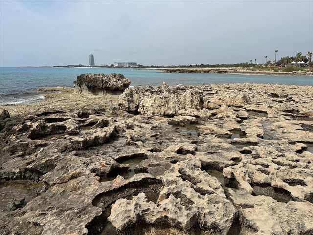
- Describe the surface of the limestone beds in front of you. Do you see any sort of pattern with the spacing or orientation of the grykes, or do they appear to be random? Next, describe the runnels and solution pits that are present.
- Based on your observations, which feature(s) is most common? How do you think this landscape will change over time? Explain.
- Upload a photo with either yourself or a personal object, at the clints and grykes on Nissi Island.
Nissi Beach is a well known coastal destination famous for its soft white sand and crystal clear blue waters. The beach is characterized by a shallow shoreline, making it ideal for wading and swimming. A unique feature of Nissi Beach is the small island just offshore which can be reached on foot via a natural sandbar that emerges at low tide.
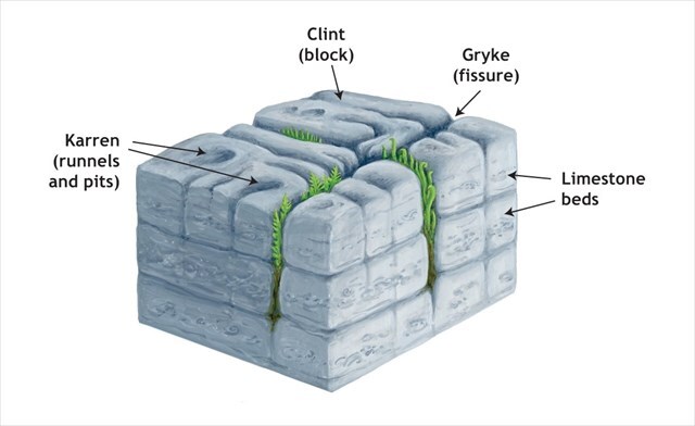
At the listed coordinates there is an opportunity to see a unique landscape that was shaped into the limestone beds, which are often exposed as flat expanses called limestone pavement. These features formed over the course of millions of years through the accumulation and compaction of calcium-rich marine sediments. Where overlying material has been eroded away, these flat lying rock layers become visible at the surface. The distinctive blocky terrain you’re looking at consists of features known as clints and grykes, which have been formed by the chemical weathering of limestone by slightly acidic rainwater.
Clints are the solid blocks of limestone that remain between widened joints on the pavement. Usually flat-topped and polygonal in shape, their size and orientation reflect the original fracture pattern of the bedrock. Because they are composed of relatively resistant limestone, the surfaces of clints often appear smooth or gently sculpted from repeated exposure to wetting, drying, and chemical dissolution.
Grykes are the deep, narrow fissures that cut between the clints. They form along natural joints in the limestone that have been widened over time by solution weathering. As rainwater (which is slightly acidic due to dissolved carbon dioxide) seeps into these cracks, it dissolves the limestone along the joint planes. Grykes can vary widely in depth and width depending on the thickness of the limestone bed, the length of time it’s been exposed, and the climate conditions.
Lastly, are karren which are small scale solutional features that develop on exposed limestone surfaces, particularly on clints. They include runnels which are narrow, shallow grooves carved by the consistent flow of acidic water, as well as solution pits which are small, rounded depressions where water has pooled and dissolved the rock more deeply. The formation of karren is shaped by the direction of water flow, the texture of the limestone surface, and variations in rock composition.