Logging Requirements:
- The listed coordinates offers a birds eye perspective of surrounding landscape. Describe the morphology (shape) of the coastline in front of you. What features do you see that confirm that you are looking at a erosional (emergent) coastline?
- Suppose that the plate boundaries were located on the opposite (north) side of the island. Would you still expect to find a similar coastline here? Explain why or why not.
- Upload a photo taken at the listed coordinates. You don't have to be in the photo though it is strongly encouraged.
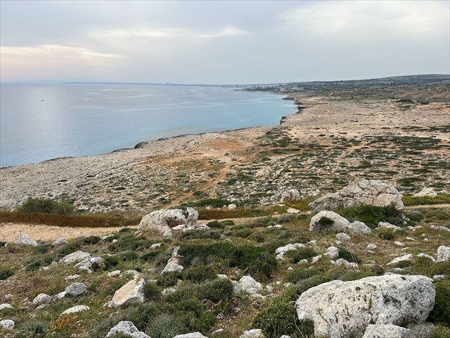
Cape Greco, on the southeastern coast of Cyprus, is known for its rugged cliffs, hidden sea caves, and clear blue waters. A popular spot for hiking, swimming, and sightseeing, it offers some of the island’s best coastal views. Visitors can explore scenic trails, discover quiet coves, or simply enjoy the fresh sea air while taking in the stunning landscape.
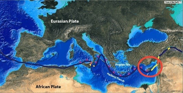
Before we dive into the main lesson, it is first important to understand how the island was formed. Cyprus (circled in red in map above) sits near the boundary between the African and Eurasian plates, where complex interactions create a zone of active tectonics. The African Plate is slowly moving northward, colliding with and subducting beneath the Eurasian Plate. This collision has led to the uplift of the island and the formation of mountain ranges such as the Troodos Mountains, which are made up of ancient oceanic crust that was pushed upward.
Geomorphology is the study of how the Earth's surface evolves as landforms develop, change, and break down over time. The shape of coastlines plays a key role in this, as it reflects the influence of waves, currents, and long term changes in sea level. While it’s easy to focus on the small details, stepping back and looking at the bigger picture can often tell us more about how an area was formed. For example, coastlines come in two main types, erosional (emergent) and depositional (submergent), with each shaped by different processes that have influenced the landscape over time.
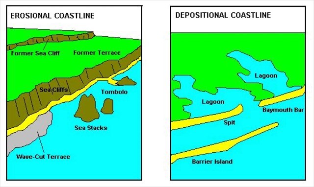
Erosional (emergent) coastlines form where wave energy or ocean currents are strong and where there is little sediment available for deposition. In these areas, erosion becomes the dominant force shaping the landscape. The coast is often narrow and made up of resistant rock that can withstand heavy wave impact. Features like sea cliffs, wave cut platforms, arches, and stacks develop as waves gradually wear into cracks and fractures in the rock. These coastlines often occur along active plate margins where the land is slowly rising and few large rivers exist to deliver sediment to the shore. As a result, there is little material to offset the ongoing loss from erosion. Rock type, structure, wave direction, and tidal range all play a role in how the coast evolves.
In contrast, depositional coastlines form where wave energy is lower and there is an abundance of sediment available for accumulation. They tend to be broader and more gently sloped, and are often shaped by longshore currents and waves that move sand and other material along the shore. Features like beaches, spits, barrier islands, and coastal dunes are common, and form gradually as sediment settles. Depositional coastlines often result from rising sea levels or sinking land and are typically found along passive (not active) continental margins where large rivers deliver sediment to the coast. The shape and stability of a depositional coast depend on factors like wave direction, tidal range, sediment supply, and the presence of vegetation.