|

🇺🇦 Мій наступний EarthCache покаже вам геологічну таємницю в Ужгороді.
🇬🇧 My next EarthCache will show you a geological secret in Uzhhorod.
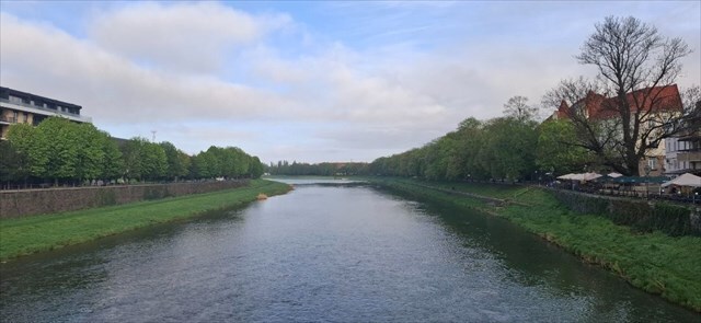
Meandering
🇺🇦 Меандрування використовується для характеристики окремих типів річок на основі їх конструкції. Розрізняють три види приток: плетені, прямі та вигнуті або змієподібні. У річках, що протікають через заплаву, звивистість зазвичай легше утворюється при невеликому ухилі.
Осад зазвичай зигзагоподібно осідає в горбку, а потім рухається звідти до берега. У поглибленнях домінує ерозія, і добре видно, як пломба відступає за рахунок відцентрової сили. Коли просування заповнення в опуклій зоні поєднується з відступом увігнутої зони, русло річки починає мігрувати і виникає звивистість.
Коли річка рухається по пористій водопроникній поверхні, краї природного проходу, через які річка продовжує текти, розмиваються. Зношуючись, він набуває характерну увігнуту форму, що створює вигин.
🇬🇧 Meandering are used to characterize specific types of rivers based on their design. There are three types of tributaries: braided, straight and curved or serpentine. In the rivers that flow through the floodplain, meandering are usually easier to form when the slope is small.
The sediment is usually deposited in the bump in a zigzag fashion and then moves from there to the shore. In the recesses, erosion dominates, and it is clear how the filling retreats due to the centrifugal force. When the advance of the fill in the convex zone is combined with the retreat of the concave zone, the river course begins to migrate and meandering occur.
As the river moves over the porous, permeable surface, the edges of the natural passage through which the river continues to flow are eroded. As it wears out, it takes on a characteristic concave shape, which creates a curve.
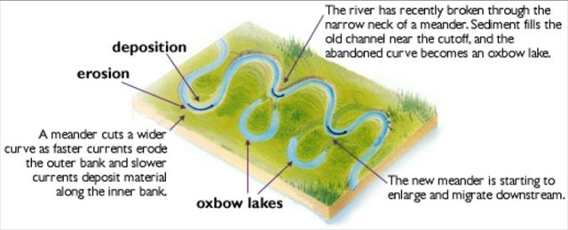
River bank types
🇺🇦 Звивисті річки чергуються місцями з швидкою та повільною течією. Глибокі басейни та перпендикулярні стіни утворюються на хвилястих берегах, де вода виносить матеріал. На протилежному березі, оскільки річка тече повільніше, відбувається відкладення матеріалу й утворення насипів. Динаміка потоку виявлялася не лише у зміні його вертикальної осі, а й горизонтальної осі зі зміщенням потоку вбік. У міру того, як русло змінювало русло та розширювалося меандри, більші й менші колоди або навіть цілі дерева входили в річки, утворюючи перешкоди в течіях і спрямовуючи силу течії на протилежний берег, часто створюючи основу для утворення нового меандру.
Рипрап-банк і рип-рап-банк — це два різних типи берегів, які зустрічаються біля меандрів. Вони відіграють важливу роль у процесі наносів річок.
Алювіальний берег, який також називають алювіальною терасою, утворюється головним чином відкладенням осаду на березі водотоку. Ці відкладення переносяться потоком води та відкладаються на березі, коли швидкість течії зменшується. Цей тип берега зазвичай широкий і має поступовий ухил. Це звичайне явище в місцях, де швидкість течії зменшується, а осад має тенденцію до відкладення.
Навпаки, берег – це берег, який піддається сильній ерозії водним потоком, особливо в меандрі. Ці береги зазвичай круті і часто мають кам’янисту або крутосхилу поверхню. Вода сильно впливає на форму цього берега, і подальша ерозія переносить матеріал з прибережного берега у воду, де він згодом осідає на алювіальному березі.
🇬🇧 Meandering rivers alternate between places with fast and slow flow. Deep pools and perpendicular walls are formed on surging banks where water removes material. On the opposite bank, as the river flows more slowly, material is deposited and embankments form. The dynamics of the flow were not only manifested by changes in its vertical axis, but also in its horizontal axis, with the flow shifting sideways. As the channel changed course and meanders widened, larger and smaller logs or even whole trees entered the rivers, forming obstacles in the flows and directing the force of the current to the opposite bank, often providing the basis for the formation of a new meander.
A riprap bank and a rip-rap bank are two distinct types of banks that occur near meanders. They play an essential role in the process of river sedimentation.
The alluvial bank, also referred to as the alluvial terrace, is formed primarily by the deposition of sediment on the bank of a watercourse. These sediments are carried by the flow of water and deposited on the bank when the flow velocity decreases. This type of bank is usually wide and has a gradual slope. It is common in places where flow velocity decreases and sediment tends to be deposited.
Conversely, a surge bank is a bank that is subject to severe erosion by water flow, especially in a meander. These banks are typically steep and often have a rocky or steeply sloping surface. Water strongly influences the shape of this bank, and subsequent erosion carries material from the riparian bank into the water where it subsequently sediments on the alluvial bank.
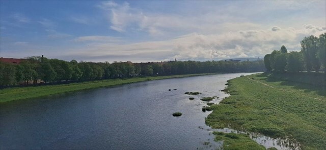
Formation process
🇺🇦 Річка несе вздовж свого русла осадові породи – дрібні шматочки скель, ґрунту та іншого матеріалу. Коли течія швидка, вона має енергію, щоб захоплювати й переносити ці частинки – цей процес називається ерозією. Але коли течія сповільнюється, деякі частинки осідають або «відкладаються». Цей постійний цикл захоплення та осадження наносів є ключовим процесом у формуванні меандрів. Вода, що тече по зовнішній стороні вигину, рухається швидше, викликаючи більшу ерозію, і з часом вигин збільшується.
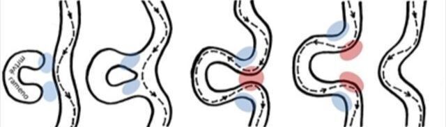
У процесі меандрування можна виділити чотири основні етапи розвитку:
Формування меандру – На цьому етапі меандр лише починає формуватися. Річка утворює перші вигини, і ерозія починає діяти на зовнішньому боці вигину.
Поступове звуження перешийка – На цьому етапі меандри вже добре розвинені й мають характерну форму з внутрішніми та зовнішніми вигинами. Ерозія посилена на зовнішньому боці, тоді як на внутрішньому накопичуються осади.
Прорив перешийка та утворення острова – На цьому етапі меандри стають дуже нестабільними – утворюється нове русло річки. Внутрішні вигини поступово замулюються, а ерозія продовжується. Річка починає утворювати нові русла, які поступово відділяються від первинних меандрів.
Утворення стариці – Стариця остаточно відділяється від річки.
🇬🇧 The river carries sediments along its course – small pieces of rock, soil, and other material. When its flow is fast, it has the energy to pick up and carry these particles, a process known as erosion. However, when the flow slows down, some of these particles settle or get “deposited.” This continuous cycle of picking up and depositing sediment is a key process in the formation of meanders. Water flowing along the outer bend of these curves moves faster, causing more erosion, and over time, the bend becomes more pronounced.
In relation to the meandering process, we can distinguish four basic stages of development:
Formation of a meander – In this stage, the meander is just beginning to form. The river creates its first bends, and erosion starts working on the outer curve.
Gradual narrowing of the neck – At this stage, the meanders are already well developed and have a characteristic shape with inner and outer bends. Erosion is stronger on the outer bend, while sediment accumulates on the inner bend.
Neck cutoff and formation of an island – At this stage, the meanders become very unstable – a new river path is formed. Sediment gradually clogs the inner bends, and erosion continues. The river begins to create new paths that gradually separate from the original meanders.
Formation of an oxbow lake – The oxbow lake becomes completely separated from the river.
🇺🇦 Для запису як "знайдено", будь ласка, надішліть мені відповіді на ці запитання через мій профіль:
1) Поясніть види меандрів. Який тип ми зустрічаємо тут, в Ужгороді?
2) Який тип берега знаходиться на західній і східній сторонах мосту в початкових координатах? Обґрунтуйте своє твердження.
3) Виходячи з вашого дослідження WP 01, у якому напрямку, швидше за все, розвиватиметься русло річки?
4) Додайте фото себе або свого GPS з меандром на початкових координатах і WP 01 в журнал.
🇬🇧 For log as "found it" please send me answers for those questions via my profile:
1) Explain the types of meanders. Which type do we encounter here in Uzhhorod? 2) What type of bank is on the west and east sides of the bridge on initial coordinates? Justify your statement.
3) Based on your examination on WP 01, in which direction will the river streamline most likely develop? 4) Add photos of yourself or your GPS with meander at the initial coordinates and WP 01 to the log.
🇺🇦 Будь ласка, зареєструйте кеш одразу після надсилання відповідей, дякую.
🇬🇧 Please log the cache immediately after sending your answers, thanks. Photos by DanielKotmel, 2025. Sources -
Meander [online]. Available from https://www.britannica.com/science/meander-river-system-component [24. 04. 2025]
Fluvial features [online]. Available from https://www.nps.gov/articles/ meandering-stream.htm [24. 04. 2025]
Stream bank [online]. Available from https://www.lakesuperiorstreams.org/ understanding/streambank.htm [24. 04. 2025]
 |