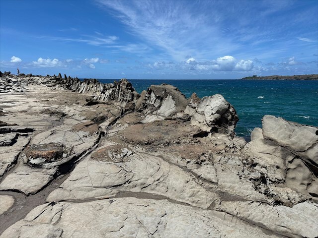
Makaluapuna Point, also called Dragon’s Teeth, is a rocky peninsula on Maui’s northwest coast. The Dragon’s Teeth are the most well-known feature here, formed when molten rock from the West Maui Volcano cooled quickly in strong ocean winds and waves. Besides these sharp lava formations, several other interesting geologic features can also be seen in the area.
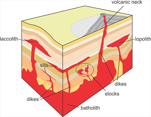
A dyke is a sheet like body of igneous rock that forms when magma intrudes into a crack and solidifies, cutting across the layers of the surrounding rock. Dykes are typically steep or vertical and are often more resistant to erosion than the surrounding material, so they may stand out as ridges in the landscape. Most dykes are composed of fine to medium grained igneous rocks like basalt (fine grained, dark volcanic rock) or diabase (medium grained, dark intrusive rock), and they commonly form in regions undergoing crustal extension, such as rift zones or volcanic arcs.
A similar feature is a sill, which is also a sheet like intrusion of igneous rock that forms when magma intrudes between existing layers of rock and solidifies parallel to the bedding planes. Unlike dykes, which cut across rock layers, sills follow the natural layering. So assuming a simplified geologic model where all the rock layers are horizontal, a dyke would run vertically while a sill would run horizontally. However it is important to note that this is all relative to the orientation of the rock layers.
Logging Requirements:
- Examine the dykes found at the posted coordinates and describe their physical characteristics (color, width, length, and anything else that stands out). Do you see any sills?
- Do you see any pattern with the position and orientation of the dykes, or does it appear to be random? Also are the thicknesses consistent or do you see slight variations?
- Upload a photo taken at Makaluapuna Point with either yourself or a personal object.
Sources:
- https://courses.lumenlearning.com/geo/chapter/reading-dikes-and-sills/
- https://geo.libretexts.org/Bookshelves/Geology/Geology_(Lumen)/09%3A_Volcanoes/9.13%3A_Reading-_Dikes_and_Sills
- https://www.geolsoc.org.uk/ks3/gsl/education/resources/rockcycle/page3598.html