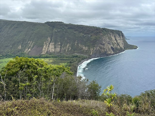
Waipiʻo Valley Overlook provides a sweeping view of the valley’s steep cliffs, black sand beach, and fertile floor below. The valley is historically significant as the childhood home of King Kamehameha I, who later unified the Hawaiian Islands. Once a thriving center for Hawaiian royalty, Waipiʻo was home to sacred heiau, royal residences, and extensive taro fields that supported generations of aliʻi.
Waipiʻo Valley was primarily formed along a major fault line on the flank of Mauna Kea, near the boundary of Kohala, where a section of the volcano’s slope dropped downward due to tectonic movement. This fault represents a zone of structural weakness where the flank of the volcano dropped downward, likely due to collapse from gravity, or tectonic movement. The initial displacement created a steep walled depression, which was then widened and deepened over hundreds of thousands of years by intense rainfall and stream erosion. Water flowing from the high slopes of Mauna Kea carved into the valley floor, which created features such as Hiʻilawe Falls along with the valley’s broad, flat bottom. The surrounding cliffs that you see are remnants of the original fault scarp.
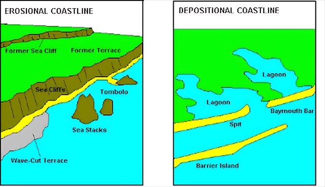
The shape of an island’s coastline is mainly influenced by wave energy, wind direction, rock type, and the availability of sediment. Erosional coastlines usually develop on the windward side of an island, where waves driven by prevailing winds strike the shore with force. These high-energy environments gradually wear away the land, especially when the coastline is made of hard volcanic rock. Waves erode the base of cliffs, causing sections of the slope to collapse and retreat inland. Because loose material is quickly carried away by the surf, these areas tend to be steep, with little to no beach.
Depositional coastlines, by contrast, form on the leeward side of the island, where wave energy is much lower. In these protected areas, sand and other sediments delivered by rivers or longshore currents are able to settle and build up over time. This leads to the formation of gently sloping shorelines, broad sandy beaches, and other low-lying features. Offshore reefs or rock formations can also help calm wave action, allowing even more sediment to accumulate.
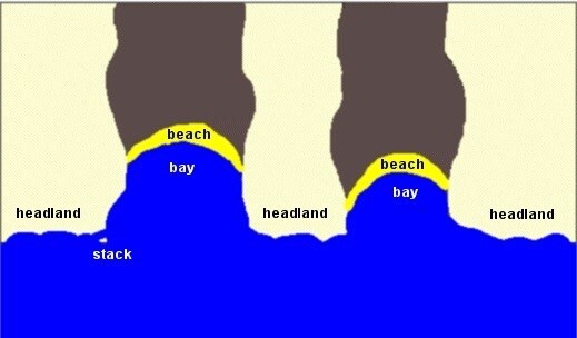
Lastly, it is worth mentioning headlands, which are elevated sections of land that extend out into the ocean or sea. They often form along rugged coastlines where more resistant rock is exposed and are typically created through differential erosion, where softer rock erodes faster than harder rock leaving the more durable material jutting out into the water. As waves continuously erode the coastline, the harder rock forming the headlands remains, while bays form in the more easily eroded areas in between. Headlands often face high wave energy and are key features of erosional coastlines, frequently marked by steep cliffs and limited beach area.
Logging Requirements:
- When you look at the headlands to the right of the sea cliffs, you might notice they appear relatively flat (compared to rest of coastline). Why do you think this is the case?
- Based on your observations and what you have learned, are you on the windward or leeward side of the island? How do you think this stretch of coastline in this area will change over time? Explain.
- Upload a photo taken at the Waipio Valley Overlook with either yourself or a personal object.
Sources:
- https://www.e-education.psu.edu/earth107/node/1270
- https://wacoastalnetwork.com/wp-content/uploads/2020/02/Erosion-and-Deposition-Introduction_2.18.20.pdf