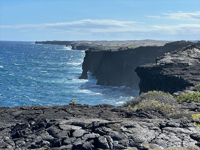
The Kamokuna area of Hawaiʻi Volcanoes National Park lies along a rugged stretch of coastline which was shaped by Kīlauea’s past eruptions. Sheer cliffs of basalt rise directly from the Pacific where lava once flowed into the ocean, forming unstable lava deltas. The shoreline is constantly changing due to erosion and occasional collapses of the volcanic rock, and the area includes remnants of hardened lava flows, fissures, and vent structures from previous eruptions.
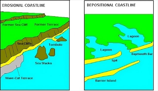
If you look at the coastline here, you may notice that it looks a lot different from what can be seen at some of the popular tourist resorts at the west side of the island. Coastlines fall into two categories, each formed by different processes. Erosional coastlines are shaped primarily by the force of waves, currents, and weathering, which wear away rock and sediment. They may include features such as sea cliffs, wave cut platforms, sea arches, and stacks. These coastlines are typically rugged, with steep profiles and limited sediment accumulation. In contrast, depositional coastlines develop where wave energy and currents slow down, which allows sediments to settle and build up. This results in landforms like sandy beaches, barrier islands, spits, and deltas, which are generally lower in relief and constantly reshaped by the movement of sediment.
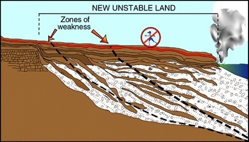
Much of the land you see in this area is actually made up of lava deltas, which are new landforms created when lava flows from a volcano reach the ocean and solidify upon contact with water. As molten lava pours into the sea the outer surface cools quickly, forming a hardened crust, while the interior remains molten and continues to flow. Over time, repeated lava flows build out from the shore, which creates a delta of unstable rock that extends into the water. These deltas are prone to sudden collapse because the newly formed land is often fractured and undercut by waves.
The reason lava deltas are unstable is partly due to thermal shock, which occurs when a material experiences a sudden and extreme change in temperature, which causes rapid expansion or contraction. In volcanic areas, this often happens when lava, which can exceed 1000 °C, comes into contact with much cooler water, around 25 °C. The abrupt temperature difference creates intense internal stresses within the rock, leading to cracks and fractures that weaken its structure and make it more likely to break or collapse. A common example of thermal shock is pouring cold water onto a hot glass, which can cause the glass to crack.
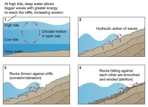
Coastal erosion also plays a role in shaping the coastline in front of you, and occurs through several processes, the most common being hydraulic action, abrasion, and attrition. Hydraulic action happens when waves crash against the shore forcing water and air into cracks in the rock, which increases pressure and eventually causes pieces to break off. Next is abrasion, which occurs when waves hurl sand, pebbles, and larger rocks against the coastline, wearing it down like sandpaper. Lastly there is attrition, which happens when rocks and sediments carried by waves collide with each other, gradually breaking into smaller, smoother pieces.
Logging Requirements:
- Describe the section of coastline in front of you. What form(s) of coastal erosion do you think has had the greatest imoact on shaping the coastline in front of you? Explain.
- Looking around, do you see any evidence of prior lava delta collapse? If so, describe what you see.
- Upload a photo with either yourself or a personal object near the listed coordinates.
Sources:
- https://www.usgs.gov/media/images/active-lava-deltas-are-unstable-kilauea-hawaii
- https://www.vulkaner.no/v/vulkinfo/tomhaz/hawaiix3.html
- https://www.sciencedirect.com/science/article/pii/S0169555X22003208
- https://en.wikipedia.org/wiki/Lava_delta