
The Three Eyes National Park is a 50-yard open-air limestone cave located in Mirador del Este park, within the Santo Domingo Este municipality of the Dominican Republic. The park features a series of three lakes, or ojos, and is one of the country's most popular tourist attraction.
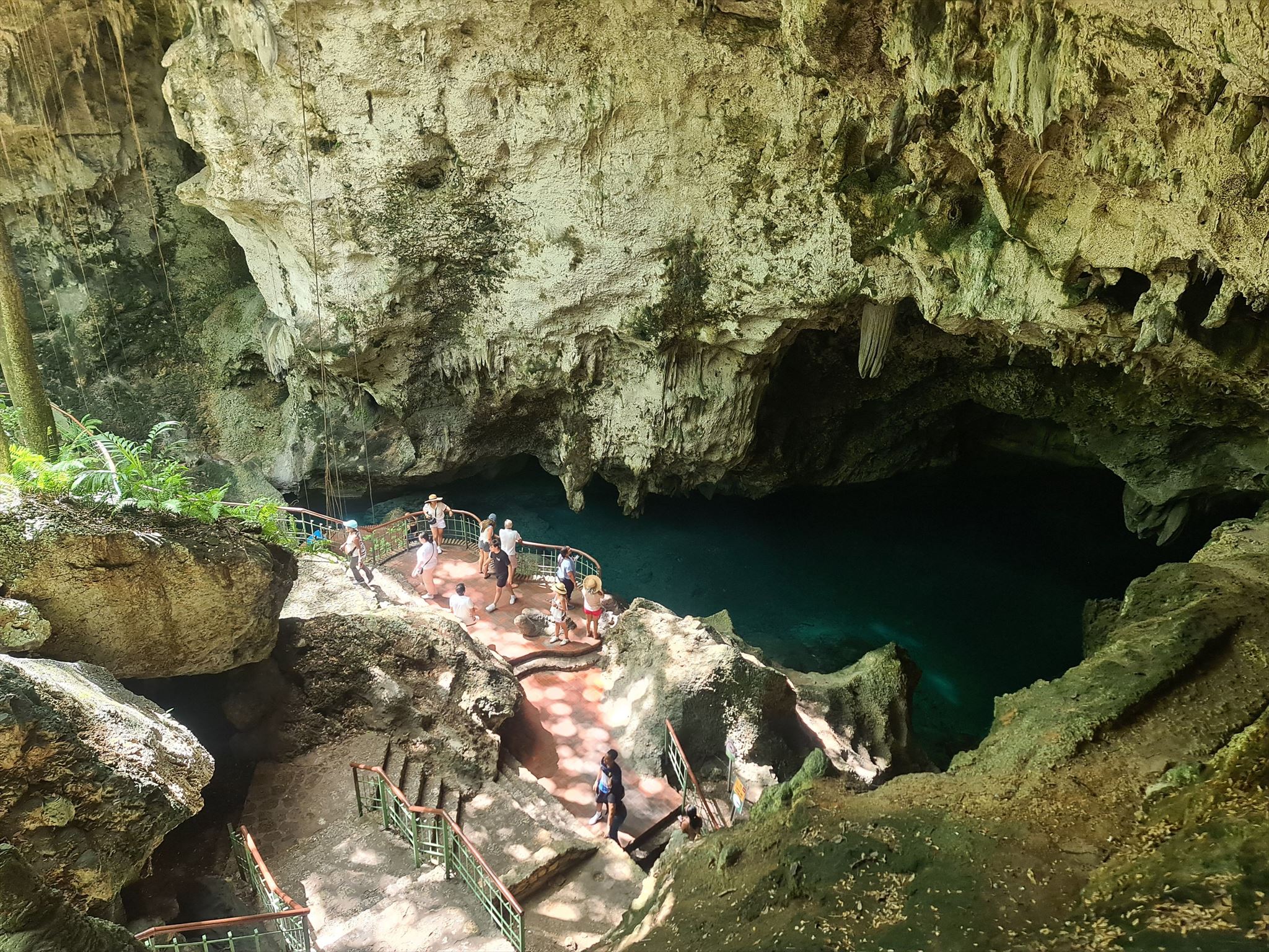
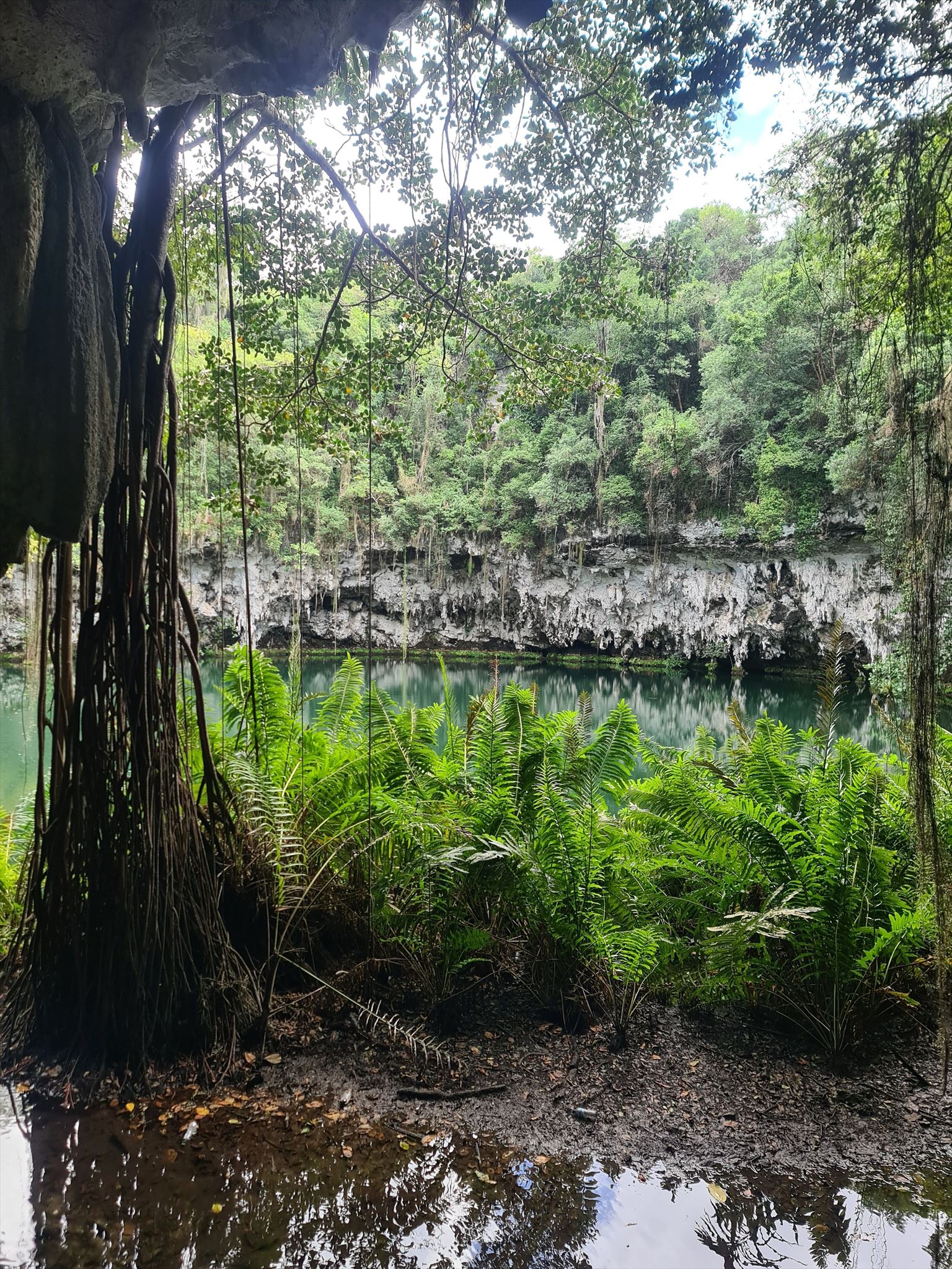
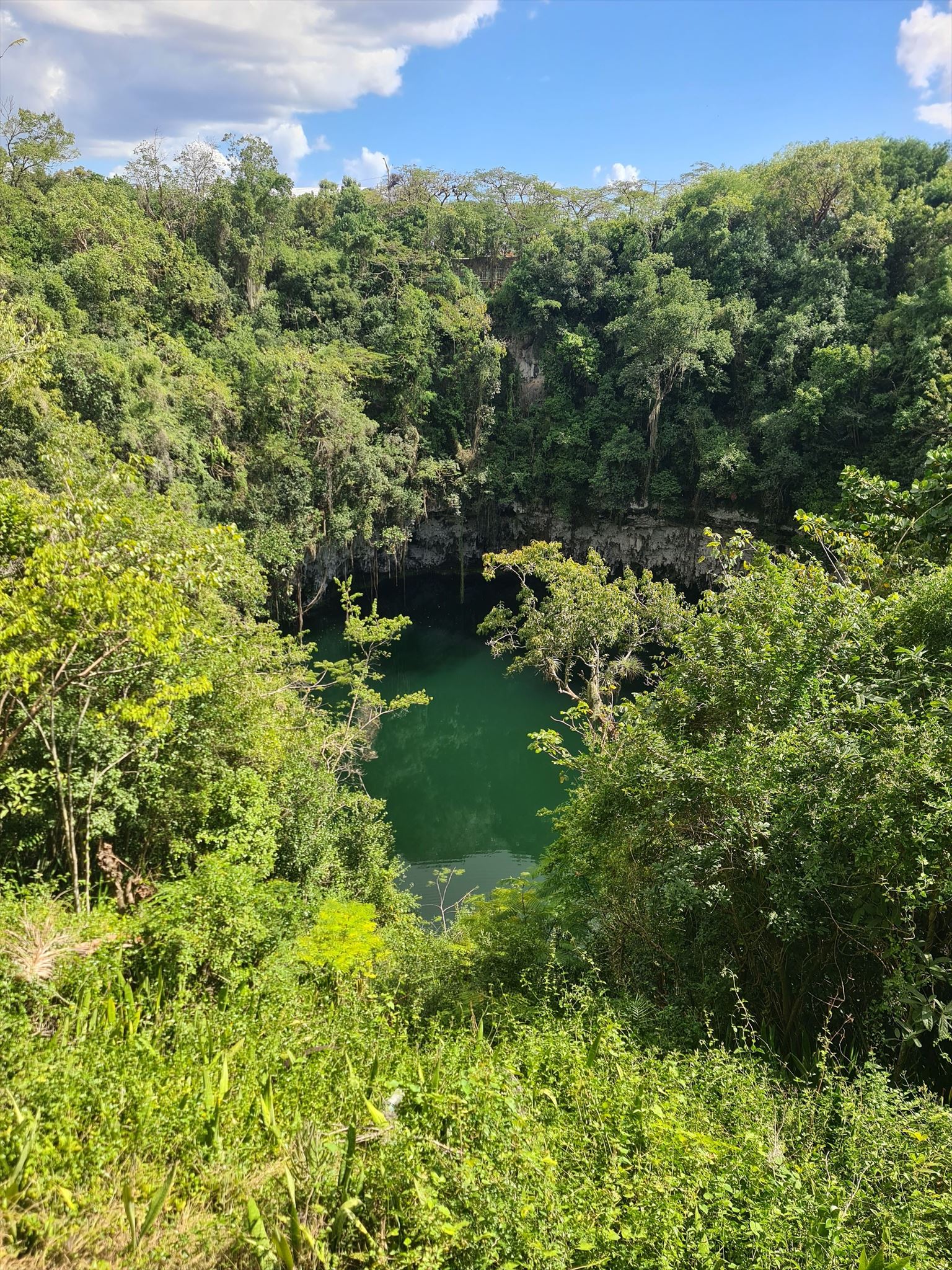
The site was created centuries ago as a result of tectonic fractures when caves collapsed, forming a bowl-shaped depression which subsequently filled with water. Initially, the cave was used by the indigenous Taíno Indians for religious rituals and fertility rites. The Taíno were the first inhabitants of the Hispaniola island. The three main lakes are called "Lago de Azufre" (discovered in 1916), "La Nevera" and "El Lago de las Damas". Some of the lakes also have openings on the outside. A staircase carved into the rock gives access to the first cave while a boat takes visitors across the second lake to give access to a fourth lake called "Los Zaramagullones". This lake is not considered one of the three "eyes" or main lakes, as it has an opening to the outside.
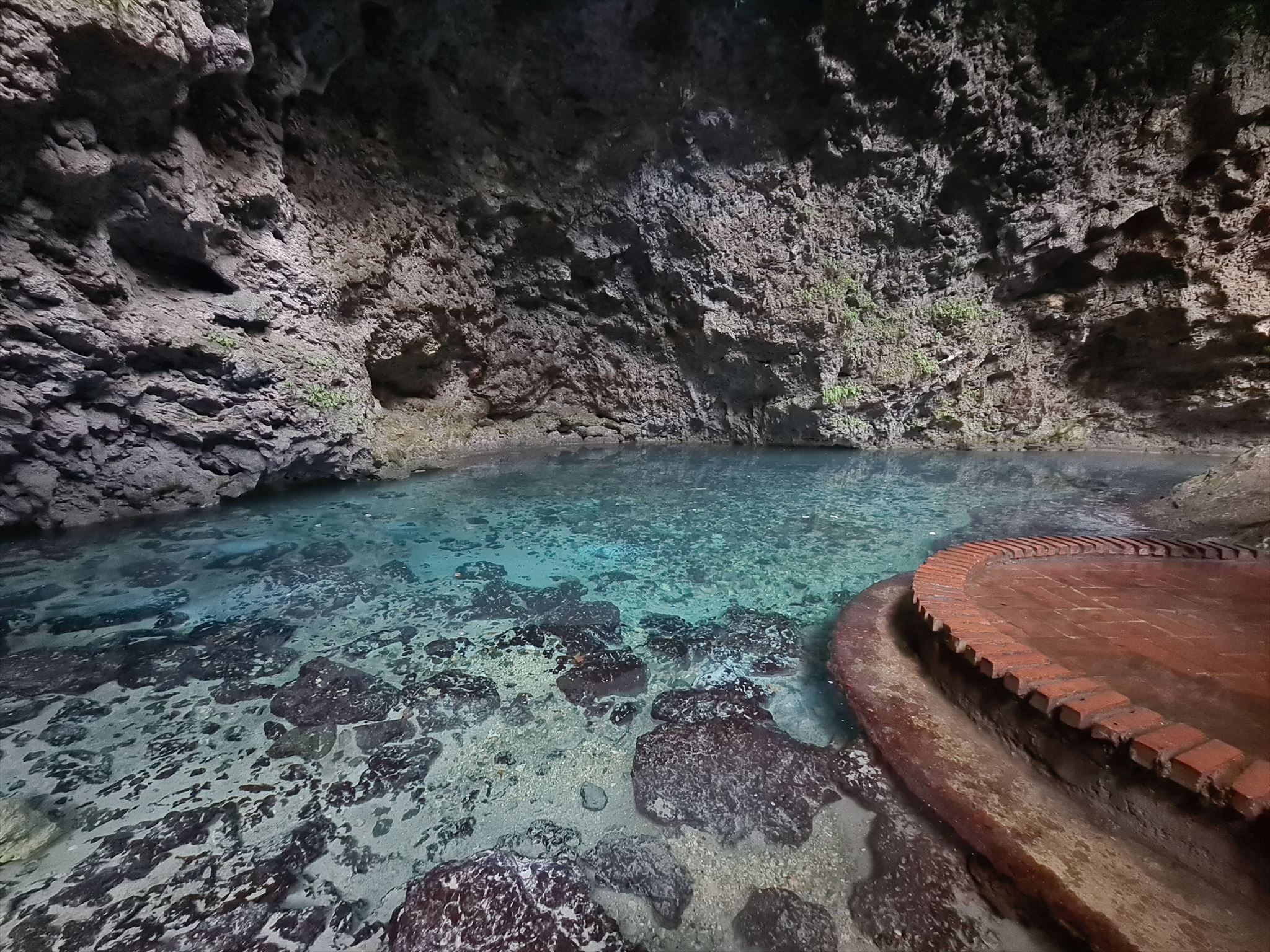
The caves are fed by water from an underground river and surrounded by stalactites and stalagmites. The composition of the water varies. Early explorers believed that the first pond was made up of sulphurous water because of its blue hue. However, after testing, it was discovered that Lago Azufre is actually composed of calcium minerals. The fourth and deepest lagoon is freshwater. It was stocked with fish back in the 1940s. The temperature of the lagoons varies between 20 °C to 29 °C, depending on the site. There varying depths create different colored reflections — blue, green, and sometimes yellow. The depth of the shallowest lagoon, Lago de las Damas, has a depth of 8 feet, while the deepest, Los Zaramagullones, reaches 25 feet.
To visit all four lagoons, one needs to be able to climb stairs. There are a total of 346 steps connecting the four lagoons. The furthest lagoon, Lago Los Zaramagullones, can only be accessed by a small ferry raft pulled via rope across Lago La Nevera. Los Zaramagullones is often considered the most tranquil and beautiful of the four lagoons.
Lago Azufre
The first and largest of the lakes, Lago Azufre (Sulphur lake), is characterized by its deep blue color caused by the high sulfur content. The lake reaches a depth of up to 18 meters and its water is exceptionally clean. Visitors can observe the various species of fish that live here. There are well-maintained trails and viewing platforms around the lake, from which the entire scenery can be observed.
Lago La Nevera
The second lake, known as La Nevera (The Refrigerator), is named for its colder water. This lake is partially covered by a rocky overhang, which creates interesting light effects on the water surface. The water here has a darker shade and the lake is surrounded by lush vegetation, which creates a mystical atmosphere.
Lago de las Damas
The third lake, Lago de las Damas (Lake of the Ladies), is the smallest of the three main lakes. It is named after legends about women who used to wash clothes here in the past. This lake is known for its crystal clear water and peaceful atmosphere.
Lago Los Zaramagullones
The fourth, often overlooked lake, accessible only by small boat. This lake is unique in that it is partially connected to the sea and its level fluctuates with the tides. It offers visitors the opportunity to observe an interesting mix of freshwater and brackish ecosystems.
These kinds of lakes are often called as "Cenotes".
Cenote is a natural, flooded sinkhole of karst origin, which can be found primarily on the Yucatán Peninsula in Mexico, where there are thousands of them, but they can be also observed in many islands of Caribbean. They are formed by the collapse of limestone bedrock, exposing groundwater. The word “cenote” comes from the Mayan word for well or abyss. For the ancient Maya, cenotes were an important source of drinking water and a gateway to the Mayan underworld. Today, they are popular for swimming, snorkeling, and diving in their clear water.
The Geology of Cenotes
Cenotes are a direct result of the geological history. Over time, thick layers of limestone accumulated from marine organisms, eventually forming a platform that was exposed when sea levels receded. This left the peninsula with a porous limestone bedrock, which became the foundation for the formation of cenotes.
The formation of cenotes is largely due to a process known as karstification. Rainwater, slightly acidic from absorbing carbon dioxide in the air, seeps into the ground and dissolves the limestone over time. This slow erosion creates underground caves and tunnels, and as the ceilings of these caves collapse, they reveal the stunning cenotes we see today.
Limestone plays a crucial role in the formation of cenotes and is composed primarily of calcium carbonate, which dissolves when it comes into contact with acidic water. Over thousands of years, this interaction between water and rock creates vast networks of caves and sinkholes. This porous rock not only facilitates the creation of cenotes but also influences their water quality. The natural filtration through limestone results in the crystal-clear waters that make cenote diving so appealing. The purity of the water allows for visibility that can exceed 100 feet, giving divers an unparalleled view of the underwater world.
Water is the driving force behind cenote formation. As rainwater seeps through the ground and interacts with limestone, it carves out intricate cave systems beneath the surface. Over time, these caves grow larger, and some eventually collapse, forming open cenotes that are accessible to divers and swimmers. Cenotes are often connected to vast underground river systems, which continue to shape the landscape. These water systems create complex networks of caves, some of which are still hidden beneath the surface.
This interaction between water and rock creates a dynamic, ever-changing environment that adds to the allure of cenote diving. The intricate cave systems formed by water offer divers a glimpse into the natural forces at work deep beneath the Earth’s surface.
Cenotes aren’t just geological wonders, they are also home to rich and diverse ecosystems. The clear, nutrient-rich waters of cenotes support a variety of life, from fish and turtles to unique microorganisms that thrive in the underground rivers and caves. These ecosystems are fragile and require careful management to maintain their balance.
Cenotes were first classified using a basic morphometry-based classification scheme in 1936:
1. Cenotes-cántaro (Jug or pit cenotes) have a surface relation that is narrower than the water body's diameter.
2. Cenotes-cilndricos (Cylinder cenotes) have walls that are completely vertical.
3. Cenotes-aguadas (Basin cenotes) have shallow water basins
4. Grutas (Cave cenotes) have a horizontal gateway and dry areas.
Since the classification scheme is dependent on morphometric observations well above the water table, it only partially represents the mechanisms by which cenotes evolved and also the inherent hydrogeochemical relationship with the corresponding flooded cave networks, that were only identified in the 1980s and subsequently with the start of cave diving exploration.
While cenotes are ancient formations, they are also fragile. Human activity, particularly from tourism and development, poses a threat to the delicate balance of these ecosystems. Pollution, deforestation, and overuse can all contribute to the degradation of cenotes, making conservation efforts more important than ever. The responsibility to protect cenotes is clear. The future of cenotes depends on a collective effort to protect and conserve these unique formations. As more people discover the beauty of cenote diving, the need for responsible tourism becomes increasingly important.
* * * * * * * * * * * *
Your tasks are:
1) What is cenote and how can be formed and created?
2) Which type of cenote (according to listing), do you think, the Los Tres Ojos is?
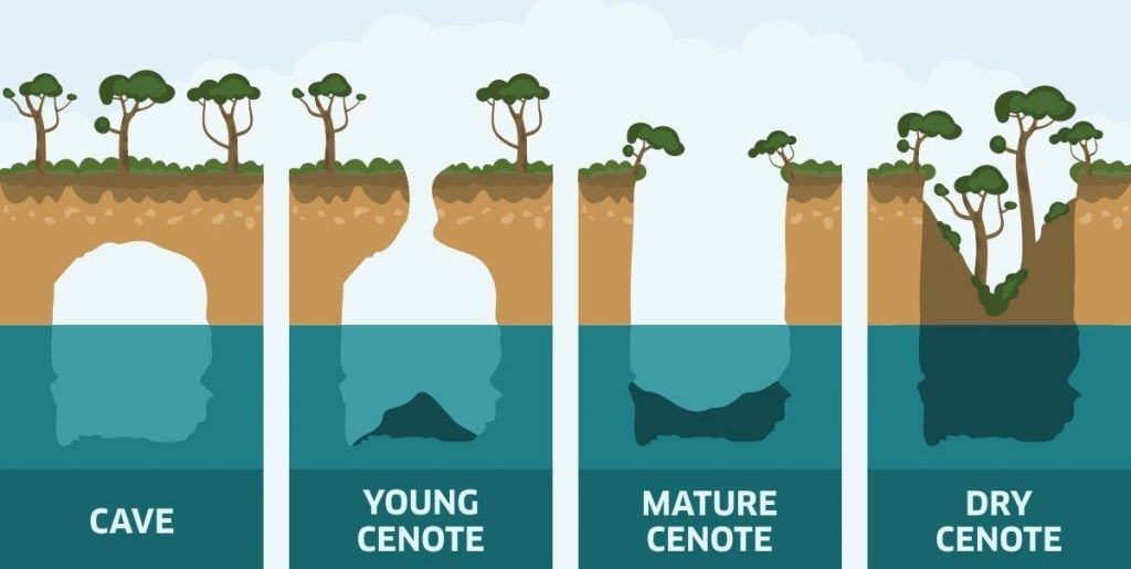
3) Which stage of cenote (according to picture from listing), do you think, the Los Tres Ojos is?
4) Which kind of speleothems, you can observe in Los Tres Ojos?
5) Try to immerse your hand into the water. How is the temperature of the water? Is it cold, as in another caves? Why?
6) Please post a photo from Lago Los Zaramagullones (you have to reach it by the raft) and add it to your log. There is a nice photo spot on the wood platform. It is a proof for me, that you have been here.
* * * * * * * * * * * *
Your right answers send me via message center or email through my profile, than you can log your visit. If your answers aren't correct, I will give you an echo. Please respect a rule - 1 log = 1 email with answers. In that case i will be uncompromising, who will log without sending answers, he will be deleted. It is a proof for me, that you were there and do something for a point. And please no retrespective logs from your sofa!
* * * * * * * * * * * *

Summary translation via translator, sorry I can't speak spanish. If some kind geocacher would like to translate it, please contact me.
El Parque Nacional Tres Ojos es una cueva de piedra caliza al aire libre de 50 yardas ubicada en el parque Mirador del Este, dentro del municipio de Santo Domingo Este, República Dominicana. El parque cuenta con una serie de tres lagos, u ojos, y es una de las atracciones turísticas más populares del país.
El sitio se formó hace siglos como resultado de fracturas tectónicas al derrumbarse cuevas, formando una depresión en forma de cuenco que posteriormente se llenó de agua. Inicialmente, la cueva fue utilizada por los indígenas taínos para rituales religiosos y de fertilidad. Los taínos fueron los primeros habitantes de la isla La Española.
Los tres lagos principales se llaman "Lago de Azufre" (descubierto en 1916), "La Nevera" y "El Lago de las Damas". Algunos de estos lagos también tienen aberturas al exterior. Una escalera excavada en la roca da acceso a la primera cueva, mientras que una lancha lleva a los visitantes a través del segundo lago para acceder a un cuarto lago llamado "Los Zaramagullones". Este lago no se considera uno de los tres "ojos" o lagos principales, ya que tiene una abertura al exterior.
Las cuevas se alimentan de agua de un río subterráneo y están rodeadas de estalactitas y estalagmitas. La composición del agua varía. Los primeros exploradores creían que el primer estanque estaba compuesto de agua sulfurosa debido a su tono azul. Sin embargo, después de realizar pruebas, se descubrió que el Lago Azufre en realidad está compuesto de minerales de calcio. La cuarta laguna, la más profunda, es de agua dulce. Fue repoblada con peces en la década de 1940. La temperatura de las lagunas varía entre 20 °C y 29 °C, según el sitio. Sus diferentes profundidades crean diferentes reflejos de colores: azul, verde y, a veces, amarillo. La laguna más superficial, el Lago de las Damas, tiene una profundidad de 8 pies, mientras que la más profunda, Los Zaramagullones, alcanza los 25 pies.
Para visitar las cuatro lagunas, es necesario subir escaleras. Hay un total de 346 escalones que las conectan. A la laguna más alejada, el lago Los Zaramagullones, solo se puede acceder mediante una pequeña balsa tirada con cuerdas a través del lago La Nevera. Los Zaramagullones suele considerarse la más tranquila y hermosa de las cuatro lagunas.
Lago Azufre
El primero y más grande de los lagos, el Lago Azufre, se caracteriza por su intenso color azul debido a su alto contenido de azufre. El lago alcanza una profundidad de hasta 18 metros y sus aguas son excepcionalmente limpias. Los visitantes pueden observar las diversas especies de peces que habitan aquí. Alrededor del lago hay senderos bien mantenidos y miradores desde los que se puede contemplar todo el paisaje.
Lago La Nevera
El segundo lago, conocido como La Nevera, recibe su nombre por sus aguas más frías. Este lago está parcialmente cubierto por un saliente rocoso, lo que crea interesantes efectos de luz en la superficie del agua. El agua aquí tiene un tono más oscuro y el lago está rodeado de exuberante vegetación, lo que crea una atmósfera mística.
Lago de las Damas
El tercer lago, el Lago de las Damas, es el más pequeño de los tres principales. Recibe su nombre de las leyendas sobre mujeres que lavaban ropa aquí en el pasado. Este lago es conocido por sus aguas cristalinas y su ambiente tranquilo.
Lago Los Zaramagullones
El cuarto lago, a menudo pasado por alto, es accesible solo en pequeñas embarcaciones. Este lago es único porque está parcialmente conectado al mar y su nivel fluctúa con las mareas. Ofrece a los visitantes la oportunidad de observar una interesante mezcla de ecosistemas de agua dulce y salobre.
A este tipo de lagos se les suele llamar “Cenotes”.
Un cenote es un sumidero natural inundado de origen kárstico, que se encuentra principalmente en la península de Yucatán, México, donde existen miles, pero también se pueden observar en muchas islas del Caribe. Se forman por el colapso de la roca caliza, dejando expuestas las aguas subterráneas. La palabra "cenote" proviene del término maya para pozo o abismo. Para los antiguos mayas, los cenotes eran una importante fuente de agua potable y una puerta de entrada al inframundo maya. Hoy en día, son populares para nadar, practicar snorkel y bucear en sus aguas cristalinas.
La geología de los cenotes
Los cenotes son un resultado directo de la historia geológica. Con el tiempo, gruesas capas de piedra caliza se acumularon a partir de organismos marinos, formando una plataforma que quedó expuesta al bajar el nivel del mar. Esto dejó en la península un lecho de roca caliza porosa, que sirvió de base para la formación de los cenotes.
La formación de cenotes se debe en gran medida a un proceso conocido como karstificación. El agua de lluvia, ligeramente ácida por la absorción de dióxido de carbono del aire, se filtra en el suelo y disuelve la piedra caliza con el tiempo. Esta lenta erosión crea cuevas y túneles subterráneos, y a medida que los techos de estas cuevas se derrumban, revelan los impresionantes cenotes que vemos hoy.
La piedra caliza desempeña un papel crucial en la formación de cenotes y está compuesta principalmente de carbonato de calcio, que se disuelve al entrar en contacto con agua ácida. A lo largo de miles de años, esta interacción entre el agua y la roca crea vastas redes de cuevas y sumideros. Esta roca porosa no solo facilita la formación de cenotes, sino que también influye en la calidad de sus aguas. La filtración natural a través de la piedra caliza da lugar a aguas cristalinas que hacen del buceo en cenotes un atractivo innegable. La pureza del agua permite una visibilidad que puede superar los 30 metros, ofreciendo a los buceadores una vista inigualable del mundo submarino.
El agua es la fuerza impulsora de la formación de los cenotes. A medida que el agua de lluvia se filtra por el suelo e interactúa con la piedra caliza, excava intrincados sistemas de cuevas bajo la superficie. Con el tiempo, estas cuevas se agrandan y algunas acaban por derrumbarse, formando cenotes abiertos accesibles para buceadores y nadadores. Los cenotes suelen estar conectados a vastos sistemas fluviales subterráneos, que siguen moldeando el paisaje. Estos sistemas de agua crean complejas redes de cuevas, algunas de las cuales aún permanecen ocultas bajo la superficie.
Esta interacción entre el agua y la roca crea un entorno dinámico y en constante cambio que realza el atractivo del buceo en cenotes. Los intrincados sistemas de cuevas formados por el agua ofrecen a los buceadores una visión de las fuerzas naturales que actúan en las profundidades de la Tierra.
Los cenotes no son solo maravillas geológicas, sino que también albergan ecosistemas ricos y diversos. Sus aguas cristalinas y ricas en nutrientes albergan una gran variedad de vida, desde peces y tortugas hasta microorganismos únicos que prosperan en los ríos y cuevas subterráneas. Estos ecosistemas son frágiles y requieren una gestión cuidadosa para mantener su equilibrio.
Los cenotes se clasificaron por primera vez utilizando un esquema de clasificación básico basado en la morfometría en 1936:
1. Cenotes-cántaro tienen una relación de superficie más estrecha que el diámetro del cuerpo de agua.
2. Cenotes-cilndricos tienen paredes que son completamente verticales.
3. Cenotes-aguadas tienen cuencas de aguas poco profundas.
4. Grutas tienen puerta de entrada horizontal y zonas secas.
Dado que el esquema de clasificación depende de observaciones morfométricas muy por encima del nivel freático, solo representa parcialmente los mecanismos por los cuales evolucionaron los cenotes y también la relación hidrogeoquímica inherente con las redes de cuevas inundadas correspondientes, que solo se identificaron en la década de 1980 y posteriormente con el inicio de la exploración del buceo en cuevas.
Si bien los cenotes son formaciones antiguas, también son frágiles. La actividad humana, en particular el turismo y el desarrollo, representa una amenaza para el delicado equilibrio de estos ecosistemas. La contaminación, la deforestación y la sobreexplotación pueden contribuir a la degradación de los cenotes, lo que hace que los esfuerzos de conservación sean más importantes que nunca. La responsabilidad de proteger los cenotes es evidente. El futuro de los cenotes depende del esfuerzo colectivo para proteger y conservar estas formaciones únicas. A medida que más personas descubren la belleza del buceo en cenotes, la necesidad de un turismo responsable cobra cada vez mayor importancia.
* * * * * * * * * * * *
Tus tareas son:
1) ¿Qué es un cenote y cómo se forma y crea?
2) ¿Qué tipo de cenote (según el listado) crees que es Los Tres Ojos?
3) ¿En qué etapa del cenote (según la imagen del listado) crees que se encuentra Los Tres Ojos?
4) ¿Qué tipos de espeleotemas puedes observar en Los Tres Ojos?
5) Intenta sumergir la mano en el agua. ¿Qué temperatura tiene? ¿Está fría, como en otras cuevas? ¿Por qué?
6) Por favor, publica una foto del Lago Los Zaramagullones (se llega en balsa) y añádela a tu bitácora. Hay un buen lugar para tomar fotos en la plataforma de madera. Es una prueba de que has estado aquí.
* * * * * * * * * * * *
Envíame tus respuestas correctas por el centro de mensajes o por correo electrónico a través de mi perfil; luego, podrás registrar tu visita. Si tus respuestas no son correctas, te enviaré un eco. Por favor, respeta la regla: 1 registro = 1 correo electrónico con respuestas. En ese caso, seré inflexible: quien registre sin enviar respuestas será eliminado. Para mí, es una prueba de que estuviste ahí y de que hiciste algo por un punto. ¡Y por favor, no registres desde tu sofá!