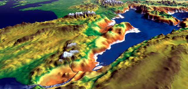
Détroit de Gibraltar – Côte marocaine
Depuis le point de vue à Tanger, vous avez une vue sur le détroit de Gibraltar et la côte européenne. La formation géologique de la côte marocaine ainsi que le paysage en face offrent un aperçu intéressant des processus géologiques de cette région.
L'EarthCache
Pour résoudre cet EarthCache, veuillez répondre aux tâches suivantes et envoyer vos réponses via le GC-Messenger. Une fois les réponses envoyées, vous pouvez enregistrer votre découverte. En cas d'incertitude ou de réponses incorrectes, je vous contacterai.
- Observe la mer : Regarde la surface de l’eau entre les côtes africaine et européenne. Vois-tu des courants, des différences de couleur ou des motifs de vagues ? Que peuvent révéler ces observations sur la direction des courants marins ?
- Réfléchis aux différences de densité : Explique avec tes propres mots pourquoi l’eau de l’Atlantique s’écoule vers la Méditerranée en surface, tandis que l’eau méditerranéenne retourne vers l’Atlantique en profondeur. Quel rôle jouent la salinité et la température dans ce processus ?
- Compare l’emplacement : Tu te trouves ici bien au-dessus du niveau de la mer. Réfléchis à la manière dont la forme du détroit (passage étroit, seuils, profondeur) influence la vitesse du courant et les échanges d’eau. Pourquoi observe-t-on des courants si puissants précisément ici ?
Photo : Prends une photo de toi ou d’un objet personnel au point de vue avec le détroit de Gibraltar en arrière-plan, et téléverse-la avec ton log de découverte.
La Méditerranée
La Méditerranée s’est formée il y a environ 150 millions d’années lorsque le supercontinent Pangée s’est fragmenté et que le continent africain a ensuite avancé vers le nord en heurtant l’Europe. Les deux continents ont ainsi entouré le bassin méditerranéen.
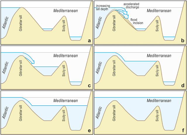
Il y a 5,6 millions d’années, la dernière connexion avec l’Atlantique, le détroit de Gibraltar, s’est fermée. L’Afrique avait avancé plus au nord et y avait formé une barrière. De plus, le niveau de l’océan a chuté de 50 mètres à cause d’une période glaciaire.
Comme les apports d’eau vers la Méditerranée étaient faibles et que le débordement depuis l’Atlantique était bloqué, la Méditerranée s’est largement asséchée, laissant un désert recouvert d’une croûte de sel d’une épaisseur de plusieurs mètres.
Il y a 5,3 millions d’années, le niveau de la mer a de nouveau monté et l’inondation a commencé. Elle s’est étalée sur plusieurs milliers d’années. Environ 90 % des volumes d’eau se seraient toutefois écoulés en seulement quelques mois, creusant un canal de 250 mètres de profondeur et 200 kilomètres de long. D’énormes masses d’eau se sont ainsi déversées dans la Méditerranée, faisant monter le niveau jusqu’à dix mètres par jour.
Salinité
L’eau de l’Atlantique qui s’écoule aujourd’hui à la surface par le détroit de Gibraltar agit comme un courant compensateur. L’eau est en moyenne à 15°C et relativement peu salée, avec 3,62 % ou 36,2 ‰. Sur son chemin vers l’est, cette eau se réchauffe et se concentre globalement d’environ 5 %.
Sans compensation du déficit en eau venant de l’Atlantique, la Méditerranée se serait asséchée en environ 2 000 ans. Le processus de concentration ferait constamment augmenter la salinité de la Méditerranée. Cela est toutefois empêché par l’écoulement continu d’eau vers l’Atlantique et, dans une moindre mesure, vers la mer Noire. Sous un flux superficiel d’eau légère à faible salinité vers la Méditerranée se produit un écoulement continu d’eau dense et très salée (environ 38,4 ‰) avec une température proche de 13°C vers l’Atlantique.
Courants
Comparés à l’Atlantique, les courants en Méditerranée sont beaucoup plus faibles. L’eau océanique entrant par la surface depuis l’Atlantique s’écoule vers l’est le long de la côte africaine. Le courant contraire dans le sens antihoraire assure un équilibre de température dans la Méditerranée. Les masses d’eau chaude du sud atteignent ainsi très loin vers le nord.
Ce transfert d’eau fonctionne si bien car il se divise en deux courants. Le premier circule en surface et correspond à l’eau venant de l’Atlantique. En raison de sa faible salinité, elle est moins dense que l’eau méditerranéenne et avance donc à la surface d’ouest en est, transportant phytoplancton et nutriments. Le second courant est l’eau méditerranéenne plus dense qui se déplace au fond vers l’Atlantique. Elle s’écoule lors des marées de la Méditerranée vers l’Atlantique. Ce flux est soutenu par la convection thermohaline.
En Méditerranée, l’eau de surface s’évapore sous un ensoleillement constant, augmentant la salinité et la densité. La couche dense descend jusqu’à rencontrer une zone ayant la même densité. En surface, cela crée un différentiel de niveau d’environ 9 cm entre la Méditerranée et l’Atlantique.
Échanges d’eau avec l’Atlantique
Ce déficit en eau est compensé par un flux constant d’eau venant de l’Atlantique par le détroit de Gibraltar. Sans cette connexion, le niveau de la Méditerranée chuterait d’environ un mètre par an. Le détroit, long de 60 km, comporte deux seuils. L’entrée est, entre Gibraltar et Ceuta, mesure environ 23 km de large et 800 m de profondeur. Suit une profonde dépression en forme de canyon, appelée le goulet de Tarifa. À son point le plus étroit, légèrement plus de 14 km, elle descend jusqu’à 1 000 m, puis remonte à 280 m au seuil de Camarinal, qui régule principalement le flux des eaux profondes méditerranéennes. 21 km plus à l’ouest, au seuil de Spartel, la Méditerranée se termine. La profondeur moyenne est de 350 m. Le détroit s’élargit ensuite à environ 44 km. L’eau méditerranéenne s’écoule alors comme une chute d’eau à une vitesse de 2-3 km/h jusqu’à 1 000 m.
L’eau de l’Atlantique entre dans la Méditerranée à un peu plus de 5 km/h sur les 100 premiers mètres. Propulsée par le flux atlantique, elle peut atteindre presque 10 km/h. Une masse d’eau inimaginable traverse le détroit dans ces deux courants opposés : 1,5 million de m³ par seconde, soit environ 1 200 fois le débit des chutes du Niagara. Grâce aux marées et à la convection thermohaline, cet échange d’eau se produit toutes les 12 heures. Pendant le flux de marée montante, l’eau de surface de l’Atlantique pénètre dans la Méditerranée, tandis que l’écoulement de l’eau profonde de la Méditerranée se produit à marée descendante.
Sources
Strait of Gibraltar – Moroccan Coast
From the viewpoint in Tangier, there is a view of the Strait of Gibraltar and the European coast. The geological formation of the Moroccan coast as well as the landscape on the opposite side provide interesting insights into the geological processes of this region.
The EarthCache
To complete this EarthCache, please answer the following tasks and send your answers via GC-Messenger. After submitting your answers, you may log your find. In case of uncertainties or incorrect answers, I will contact you.
- Observe the sea: Look at the water surface between the African and European coasts. Do you see any currents, color differences, or wave patterns? What might these observations reveal about the direction of the water flow?
- Reflect on density differences: Explain in your own words why Atlantic water flows into the Mediterranean at the surface, while Mediterranean water flows back into the Atlantic at depth. What role do salinity and temperature play in this process?
- Compare the location: You are standing clearly above sea level. Consider how the shape of the strait (narrow passage, sills, depth) influences the flow speed and water exchange. Why do such strong currents occur particularly here?
Photo: Take a photo of yourself or a personal item at the viewpoint with the Strait of Gibraltar in the background, and upload it with your found log.
The Mediterranean
The Mediterranean formed about 150 million years ago when the supercontinent Pangaea broke apart and the African continent subsequently moved northward, colliding with Europe. In doing so, both continents surrounded the Mediterranean basin.
About 5.6 million years ago, the last connection to the Atlantic, the Strait of Gibraltar, closed. Africa had moved further north and created a barrier there. In addition, the ocean level dropped by 50 meters due to an ice age.
As the inflows into the Mediterranean were low and the overflow from the Atlantic was blocked, the Mediterranean largely dried up, leaving a desert with a meter-thick salt crust.
About 5.3 million years ago, the sea level rose again, and the flooding began. It took several thousand years. However, around 90% of the water entered within just a few months, carving a 250-meter-deep and 200-kilometer-long channel into the substrate. Such immense volumes of water poured into the Mediterranean that the sea level rose by up to ten meters per day.
Salinity
The Atlantic water that currently flows at the surface through the Strait of Gibraltar acts as a compensating current. The water is on average 15°C and relatively low in salt, with 3.62% or 36.2‰. On its way eastward, this water becomes warmer and about 5% more concentrated overall.
Without compensation from the Atlantic water, the Mediterranean would dry up in about 2,000 years. The concentration process would constantly increase the salinity of the Mediterranean. However, this is prevented by the continuous outflow of water into the Atlantic and, to a lesser extent, into the Black Sea. Beneath a surface inflow of lighter, less saline water, a constant outflow of dense, salt-rich water (about 38.4‰) with an annual temperature of nearly 13°C flows into the Atlantic.
Currents
Compared to the Atlantic, currents in the Mediterranean are much weaker. Surface ocean water entering from the Atlantic flows eastward along the African coast. The counterclockwise circulation ensures a temperature balance in the Mediterranean. Warm water masses from the south reach far north.
This water exchange works so effectively because it splits into two currents. The first flows at the sea surface and corresponds to the incoming Atlantic water. Due to its low salinity, it has a lower density than Mediterranean water, moving west to east at the surface, carrying phytoplankton and nutrients. The second current is the denser Mediterranean water moving along the bottom toward the Atlantic. It flows out of the Strait of Gibraltar at ebb tide. This flow pattern is supported by thermohaline convection.
In the Mediterranean, surface water evaporates under prolonged sunlight, increasing salinity and density. The denser layer sinks until it reaches a region with the same density. At the surface, this creates a level difference of about 9 cm between the Mediterranean and the Atlantic.
Water exchange with the Atlantic
This negative water balance is compensated by a constant inflow of Atlantic water through the Strait of Gibraltar. Without this connection, the Mediterranean sea level would drop about one meter per year. The roughly 60-kilometer-long Strait of Gibraltar is divided into two thresholds. The eastern entrance, between Gibraltar and Ceuta, is about 23 km wide and 800 meters deep. Next is a deep canyon-like trench, called the Tarifa narrows. At its narrowest point, just over 14 km wide, it sinks to 1,000 meters and then rises to the shallow Camarinal sill at 280 meters, which mainly regulates the outflow of Mediterranean deep water. 21 km further west, at the Spartel sill, the Mediterranean ends. The average depth there is 350 meters. The narrow strait widens to about 44 km. From there, the outflowing Mediterranean water drops like a waterfall at 2–3 km/h to 1,000 meters.
Atlantic water enters the Mediterranean at slightly more than 5 km/h in the top 100 meters. Pushed by the strong Atlantic inflow, it can reach almost 10 km/h. An unimaginable volume of water passes through the strait in the two opposing currents: 1.5 million cubic meters per second, roughly 1,200 times the flow of Niagara Falls. Through tides and thermohaline convection, this water exchange occurs on a roughly 12-hour rhythm. During ebb and flow, surface Atlantic water flows into the Mediterranean, while bottom Mediterranean water flows out during the reverse tidal phase.
Sources
Strait of Gibraltar – Moroccan Coast
Vom Aussichtspunkt in Tanger bietet sich ein Blick auf die Straße von Gibraltar und die europäische Küste. Die geologische Formation der marokkanischen Küste sowie die Landschaft gegenüber liefern interessante Einblicke in die geologischen Prozesse dieser Region.
Der EarthCache
Um diesen EarthCache zu lösen, beantworte bitte die folgenden Aufgaben und sende deine Antworten per GC-Messenger. Nach dem Absenden der Antworten kann der Fund geloggt werden. Bei Unklarheiten oder falschen Antworten werde ich mich melden.
- Beobachte das Meer: Achte auf die Wasseroberfläche zwischen der afrikanischen und der europäischen Küste. Siehst du Strömungen, Farbunterschiede oder Wellenmuster? Was könnten diese Beobachtungen über die Bewegungsrichtung der Wasserströmungen verraten?
- Reflektiere die Dichteunterschiede: Erkläre mit deinen eigenen Worten, warum Atlantikwasser an der Oberfläche ins Mittelmeer strömt, während das Mittelmeerwasser in der Tiefe zurückfließt. Welche Rolle spielen dabei Salzgehalt und Temperatur?
- Vergleiche die Lage: Du befindest dich hier deutlich über dem Meeresspiegel. Überlege, wie die Form der Meerenge (enge Verbindung, Schwellen, Tiefe) die Strömungsgeschwindigkeit und den Wasseraustausch beeinflusst. Warum kommt es gerade hier zu solch starken Strömungen?
Foto: Mache ein Foto von dir oder einem persönlichen Gegenstand am Aussichtspunkt mit der Straße von Gibraltar im Hintergrund.
Das Mittelmeer
Das Mittelmeer entstand vor etwa 150 Millionen Jahren, als der Superkontinent Pangäa auseinanderbrach und sich anschließend der afrikanische Kontinent nordwärts bewegte und gegen Europa stieß. Dabei umschlossen beide Kontinente das Mittelmeerbecken.
Vor 5,6 Millionen Jahren schloss sich auch die letzte Verbindung zum Atlantik, die Straße von Gibraltar. Afrika war weiter nordwärts vorgerückt und hatte dort eine Barriere errichtet. Zudem sank der Wasserspiegel der Ozeane infolge einer Eiszeit um 50 Meter.
Da die Zuflüsse ins Mittelmeer gering sind und der Überlauf vom Atlantik gestoppt war, trocknete das Mittelmeer weitgehend aus und hinterließ eine Wüste mit meterdicker Salzkruste.
Vor 5,3 Millionen Jahren war der Meeresspiegel wieder gestiegen, und die Flutung setzte ein. Sie zog sich über mehrere tausend Jahre hin. Rund 90 Prozent der Wassermassen seien jedoch in nur ein paar Monaten eingeflossen und fraßen dabei einen 250 Meter tiefen und 200 Kilometer langen Kanal in den Untergrund. Dadurch ergossen sich so immense Wassermassen in das Mittelmeer, dass der Meerespegel um bis zu zehn Meter am Tag anstieg.
Salzgehalt
Das heute durch die Straße von Gibraltar an der Oberfläche einströmende Atlantikwasser gilt als Ausgleichsströmung. Das Wasser ist im Durchschnitt 15°C kühl und mit 3,62 Prozent bzw. 36,2 Promille relativ salzarm. Auf seinem Weg nach Osten wird dieses Wasser immer wärmer und insgesamt um ca. 5 Prozent konzentrierter.
Ohne die Kompensation des Wasserverlustes vom Atlantik her würde es schon in etwa 2000 Jahren austrocknen. Durch den Konzentrationsvorgang müsste der Salzgehalt (die Salinität) im Mittelmeer ständig steigen. Dies wird jedoch ähnlich wie die Verdunstung durch ständiges Abfließen von Wasser in den Atlantik, und zu einem geringen Teil in das Schwarze Meer, verhindert. Unter einem oberflächlichen Einstrom von leichtem Wasser geringerer Salinität in das Mittelmeer vollzieht sich ein ständiger Ausstrom von schwerem, salzreichen Wasser (mit etwa 38,4 Promille) und einer Temperatur von ganzjährig fast 13°C in den Atlantik.
Strömungen
Verglichen mit dem Atlantik sind die Strömungen im Mittelmeer wesentlich schwächer. Das aus dem Atlantik oberflächlich einströmende Ozeanwasser fließt ostwärts entlang der afrikanischen Küste. Die entgegen dem Uhrzeigersinn gerichtete Strömung sorgt für einen Temperaturausgleich im Mittelmeer. Warme Wassermassen aus dem Süden gelangen somit sehr weit nach Norden.
Dieser Wasseraustausch kann nur deshalb so gut funktionieren, weil sich das Ganze in zwei Strömungen teilt. Die erste Strömung verläuft an der Oberfläche des Meeres und entspricht dem vom Atlantik einströmenden Wasser. Aufgrund seiner geringen Salzkonzentration besitzt es eine kleinere Dichte als das Mittelmeerwasser, schiebt sich deshalb an der Oberfläche von West nach Ost voran und führt somit Phytoplankton und Nährstoffe mit sich. Die zweite Strömung ist das sich am Boden Richtung Atlantik bewegende Mittelmeerwasser. Es besitzt eine höhere Dichte und ist somit schwerer. Dieses Wasser fließt dann beim Gezeitenwechsel von Ebbe zu Flut aus der Straße von Gibraltar in den Atlantik. Unterstützt wird dieser Strömungsverlauf von der Thermohalinen Konvektion.
Im Mittelmeer verdunstet bei andauernder Sonneneinstrahlung das Oberflächenwasser und die Salzkonzentration steigt in diesem Bereich an. Dadurch ist dieses Wasser dichter und somit schwerer, als das darunterliegende. Die dichtere Schicht sinkt ab, bis sie auf einen Bereich trifft, der die gleichen Dichteverhältnisse besitzt. An der Meeresoberfläche ist somit ein Niveauunterschied von 9 cm zwischen Mittelmeer und Atlantik entstanden.
Wasseraustausch mit dem Atlantik
Diese negative Wasserbilanz wird durch einen ständigen Zustrom von Atlantikwasser durch die Straße von Gibraltar ausgeglichen. Würde das Mittelmeer keine Verbindung zum Atlantik haben, so würde sein Wasserspiegel jedes Jahr um ca. 1 Meter fallen. Die gut 60 Kilometer lange Straße von Gibraltar unterteilt sich in zwei Schwellen. Der östliche Eingang, zwischen Gibraltar und Ceuta, ist ca. 23 Kilometer breit und 800 Meter tief. Dann folgt eine tiefe, canyonartige Senke, Tarifa-Enge genannt. An ihrer engsten Stelle nur wenig über 14 Kilometer breit, sinkt sie auf 1.000 Meter ab, um dann zu der nur 280 Meter seichten Camarinal-Schwelle anzusteigen. Diese ist die eigentlich bestimmende "Staumauer" für den Austritt des mediterranen Tiefenstroms. 21 Kilometer weiter westlich, an der Spartel-Schwelle, endet das Mittelmeer. Die durchschnittliche Tiefe liegt dort bei 350 Meter. Zugleich weitet sich die enge Straße auf ca. 44 Kilometer aus. Von dort sinkt das abfließende Mittelmeerwasser wie ein Wasserfall mit einer Geschwindigkeit von 2-3 Stundenkilometer bis auf 1.000 Meter ab.
Das Atlantikwasser tritt mit etwas mehr als 5 Stundenkilometern in den obersten 100 Metern der Straße von Gibraltar in das Mittelmeer ein. Von der kräftigen atlantischen Flut geschoben kann es fast 10 Stundenkilometer erreichen. Eine unvorstellbare Masse Wasser passiert die Meerenge in den beiden gegenläufigen Strömungen: 1,5 Millionen Kubikmeter in der Sekunde fließen durch die Straße von Gibraltar, das entspricht rund 1200 Mal der Förderung der Niagarafälle. Durch die Gezeiten und mit Hilfe der Thermohalinen Konvektion kann dieser Wasseraustausch in etwa 12-stündlichem Rhythmus stattfinden. Während des Gezeitenwechsels von Flut zu Ebbe fließt oberflächennahes Atlantikwasser in das Mittelmeer hinein. Das Ausfließen von bodennahem Mittelmeerwasser erfolgt beim Gezeitenwechsel von Ebbe zu Flut.
Quellen