**** This is an earthcache. There is no physical container. ****
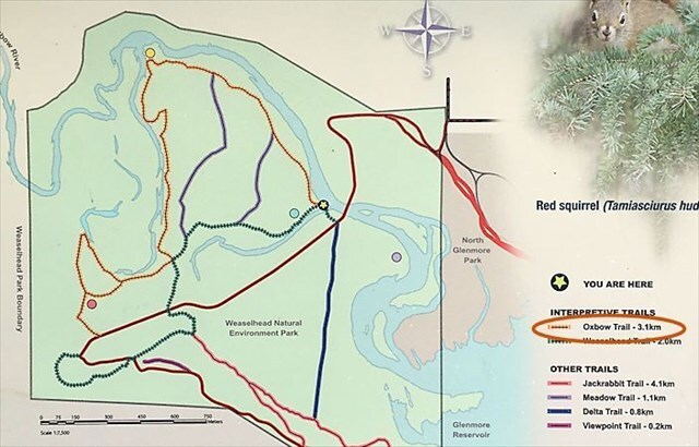
To log this earthcache, you must visit each of the reference locations during the Weaselhead Flats Natural Environment Park hours (5 a.m. - 11 p.m.) and complete the logging requirements below.
Logging requirements
1. Please post a picture of you, your group, your geocaching name, GPSr or a personal item at one of the locations.
2. Please send me the answers to the following by using either the Geocaching.com email or Message Center. Please DO NOT post these answers in your log.
- Reference point 1. Look south at the Weaselhead Meadow and describe it. Is it wet or dry, flat or hilly, what type of vegetation? Which stage of the oxbow is this an example of?
- Reference point 2. Look at the "Changing Channels" information sign. Describe the impact that humans can have on the river's course.
- Reference point 3. Look at the "A New Oxbow" information sign. In what year was the most recent change in the river's course here and why do you think it was so recent?
- Reference point 4. Describe the oxbow here. What is the width of the oxbow at the floating bridge?
Life cycle of an oxbow
An oxbow lake is a U-shaped body of water that forms when a wide meander from a river is cut off, creating a free-standing lake. It is part of the natural evolution of river systems, especially in flat plains. It is called an oxbow lake because its crescent, or U-shape, resembles an oxbow, a piece of equipment used to yoke oxen together for pulling a plow or cart. It has four main stages in its life cycle as follows:
- Meandering river
- Meander neck narrows
- Oxbow lake forms
- Oxbow lake fills in
1. Meandering river
- A river flows through a flat floodplain following the path of least resistance and begins to form meanders (bends).
- Erosion and undercutting occurs on the outer bank of each bend (due to faster flow), and deposition of silt and sediment occurs on the inner bank (due to slower flow).
Key Processes: Erosion, Deposition

2. Meander neck narrows
- The meanders become more pronounced over time.
- The neck (narrow land between two bends) gets thinner as erosion continues.
Key Process: Lateral Erosion

3. Oxbow lake forms
- In time, usually during a flood or high flow, the river breaks through the narrow neck, creating a new, straighter channel (avulsion).
- Water flows through the new channel, leaving the old meander loop isolated.
- Deposition finally seals off the cutoff from the river channel and an oxbow lake is formed.
Key Processes: River Avulsion, Deposition

4. Oxbow lake fills in
- Without the flow of the main river, the lake becomes stillwater, leading to increased deposition of silt and organic matter on its bed.
- Since its only source of water is rain, melting snow and groundwater, the oxbow lake becomes a seasonal wetland.
- As water continues to evaporate, it eventually becomes a meander scar.
Key Processes: Evaporation, Deposition

Graphical depiction of the process
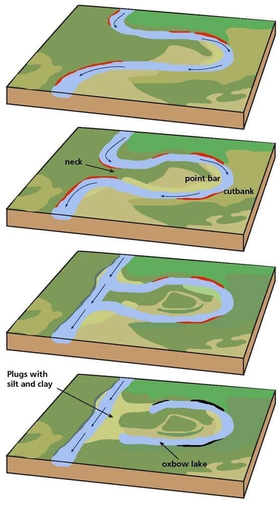
Evolution of a meandering stream includes the following: (1) stream channel within meander belt; (2) development of a nearly closed meander loop; (3) high water flowing across the neck of loop, making a cutoff; (4) deposition of sediment sealing the loop and creating an oxbow lake. Diagram: Phil Reiker, NPS Geologic Resources Division, public domain.
An animation of a meandering stream forming an Oxbow can be seen at https://youtu.be/8a3r-cG8Wic
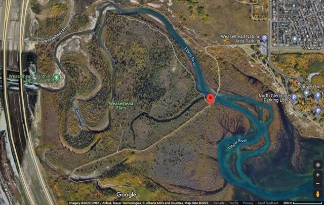
Oxbows in the Weaselhead
Go to the posted coordinates and follow the Oxbow Trail (length 3.1 km) to each of the reference points to see how new oxbows are formed and what happens to old ones.
From the satellite image below, you can see that the area has many oxbows in various stages of life. Depending upon the time of the year, some of the oxbows you see may or may not have water in them.