Praia do Carvalho – Cores, Camadas e Rocha
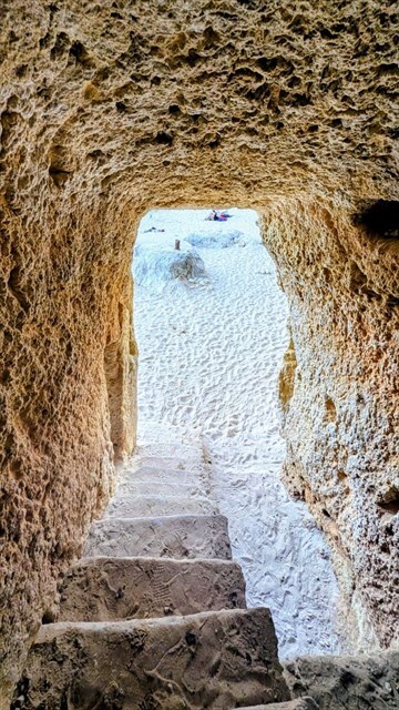
A Praia do Carvalho é uma pequena enseada protegida na costa rochosa do Algarve, entre Benagil e Carvoeiro. A praia encontra-se escondida atrás de altas falésias, com acesso por um túnel escavado na rocha. Mesmo ao percorrer este túnel, é possível observar de perto a estrutura geológica do Algarve: calcários claros com fósseis, limites de camadas, variações de cor e pequenas cavidades. Estas formações contam a história geológica de uma costa que, outrora, se situava no fundo de um mar raso e quente.
O EarthCache
Para completar este EarthCache, responda às seguintes perguntas e envie as suas respostas através do
Messenger
ou, alternativamente, por email. Após o envio das respostas, poderá registar o cache. Caso haja dúvidas ou respostas incorretas, entrarei em contacto.
- Camadas e Estrutura:
Descreva as camadas rochosas que observa no túnel ou na falésia acima da praia. Como estão dispostas (uniformes, onduladas, camadas grossas ou finas)? É possível ver fósseis, poros ou inclusões?
- Cor e Comparação:
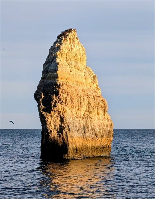
Quais cores consegue identificar nas falésias e onde se destacam mais? Compare estas cores e camadas com a rocha isolada que se encontra no mar em frente à praia. Consegue identificar as mesmas camadas e padrões de cor? Parecem estar à mesma altura que as camadas na costa?
- Arenas e Meteorização:
Observe atentamente a areia da praia. Qual a sua cor e granulometria? Acha que a areia provém da mesma rocha que forma as falésias ou de outras fontes? Justifique a sua observação.
- Tarefa Fotográfica:
Inclua uma fotografia no seu registo, mostrando-se a si (ou a um objeto pessoal) na praia, com a falésia ao fundo. Certifique-se de que não aparecem respostas na foto.
Informações Geológicas
Formação da Rocha
As rochas à volta da Praia do Carvalho são compostas por calcário da Formação Lagos–Portimão, depositado no Miocénico, há cerca de 20 a 13 milhões de anos. Estes sedimentos formaram-se num mar raso e quente, semelhante a uma lagoa tropical moderna. Inúmeros organismos com conchas calcárias viviam nesta região – incluindo moluscos, caracóis, corais, foraminíferos e algas.
Quando estes organismos morriam, os seus restos calcários afundavam-se no fundo marinho e formavam finas camadas de sedimento de carbonato de cálcio (CaCO₃). Em períodos mais calmos, depositavam-se lamas calcárias claras e finas; durante marés fortes ou aporte de materiais continentais, misturavam-se argilas, areias quartzo e minerais ricos em ferro. Assim alternavam-se camadas claras de calcário puro e camadas ligeiramente mais escuras, ricas em argila ou ferro.
Com o tempo, as camadas foram compactadas, a água dos poros expelida e o carbonato de cálcio precipitado novamente – um processo denominado diagénese. O sedimento solto transformou-se em calcário sólido. Pequenas cavidades, poros e fósseis foram preservados e ainda hoje caracterizam a aparência da rocha.
Depósitos de Sedimento e Coloração
As diferenças de cor que hoje observamos resultam de dois fatores:
– Variações nas condições de deposição durante a sedimentação (mais ou menos ferro, argila ou cálcio).
– Reações químicas após a litificação: compostos de ferro dissolvidos oxidaram para tons avermelhados e ocres; matéria orgânica originou áreas cinzentas ou castanhas.
Assim, as rochas contam não apenas a história do antigo mar, mas também as alterações químicas posteriores causadas por água, oxigénio e microrganismos.
Erosão e Formação Costeira
À medida que a região do Algarve emergiu do mar, o vento, a chuva e as ondas começaram a moldar os calcários suaves. Através de processos kársticos, o calcário dissolve-se lentamente com a chuva ligeiramente ácida, formando grutas, fissuras e cavidades. Na costa, a acção das ondas e a maresia contribuem adicionalmente para a erosão. Ao longo de milénios, formaram-se as típicas costas rochosas, arcos e túneis do Algarve, incluindo o túnel que dá acesso à Praia do Carvalho.
Um exemplo impressionante desta erosão contínua é o bloco rochoso isolado que se encontra atualmente no mar em frente à praia. As suas camadas e padrões de cor idênticos mostram que já foi parte da mesma falésia de calcário que as rochas em terra. Com o recuo gradual da linha costeira, separou-se pela acção das ondas e desmoronamentos – um remanescente da antiga costa. Esta rocha ilustra claramente como a costa do Algarve mudou ao longo do tempo: o que outrora se situava mais no mar foi gradualmente erodido e remodelado pelas forças naturais.
A Areia da Praia
A areia fina e amarelada da Praia do Carvalho é constituída principalmente por grãos de quartzo e partículas de calcário finamente trituradas.
Origina-se maioritariamente da meteorização e desintegração das falésias de calcário, mas é também transportada por correntes marinhas de praias vizinhas e do fundo do mar.
Como o calcário é quimicamente solúvel, os grãos finos de carbonato de cálcio dissolvem-se na água do mar com o tempo, enquanto os grãos de quartzo mais duros permanecem. Por isso, a areia é frequentemente bege clara a dourada e tem uma textura fina a ligeiramente pulverulenta.
Ao contrário de praias de origem vulcânica ou granítica, a areia aqui contém muito poucos minerais escuros.
A areia representa assim um ciclo geológico longo:
Organismos marinhos → deposição de carbonato de cálcio → formação de calcário → erosão pela água e vento → transporte de volta para a praia.
Presente
Atualmente, a Praia do Carvalho é um local geologicamente activo. A erosão, as alterações do nível do mar e os processos químicos moldam continuamente a enseada. Cada desmoronamento, nova fissura e grão de areia faz parte de um sistema que tem evoluído há milhões de anos e continuará a moldar-se nos séculos vindouros.
Fontes
- Geological Survey of Portugal (LNEG): Sedimentary formations of the Miocene in the Algarve Basin
- Universidade Nova de Lisboa: The Neogene of Algarve, Portugal
- Universidade do Algarve – Departamento de Ciências da Terra: Geologia da Costa do Algarve
- Fotografias © RauGeo
Praia do Carvalho – Colors, Layers and Rock
Praia do Carvalho is a small, sheltered cove on the rocky Algarve coast between Benagil and Carvoeiro. The beach is hidden behind high cliffs, and access is through a tunnel carved into the rock. Even on the way through this tunnel, you can observe the geological structure of the Algarve up close: light limestone with fossil inclusions, layer boundaries, color variations, and small cavities. They tell the geological story of a coastline that once lay at the bottom of a warm, shallow sea.
The EarthCache
To complete this EarthCache, answer the following questions and send your answers via
Messenger
or alternatively by email. Once your answers are submitted, you may log the cache. If there are any uncertainties or incorrect answers, I will contact you.
- Layers and Structure:
Describe the rock layers you can see in the tunnel or on the cliff above the beach. How are they arranged (even, wavy, thick or thin layers)? Are there visible fossils, pores, or inclusions?
- Color and Comparison:
Which colors can you observe on the cliff faces, and where are they particularly noticeable? Compare these colors and layers with the isolated rock standing in the sea in front of the beach. Can you see the same layers and color patterns there? Do they appear to be at the same height as the layers on the coast?
- Sand and Weathering:
Examine the sand on the beach closely. What color and grain size does it have? Do you think the sand originates from the same rock that forms the cliffs, or from other sources? Explain your observation.
- Photo Task:
Include a photo in your log showing yourself (or a personal item) on the beach with the cliff in the background. Make sure no answers are visible in the photo.
Geological Information
Rock Formation
The rocks around Praia do Carvalho are composed of limestone from the Lagos–Portimão Formation, deposited in the Miocene, about 20 to 13 million years ago. These sediments formed in a shallow, warm sea, similar to a modern tropical lagoon. Numerous organisms with calcareous shells lived there – including bivalves, snails, corals, foraminifera, and algae.
When these organisms died, their calcareous remains sank to the seabed and formed fine sediment layers of calcium carbonate (CaCO₃). During calmer periods, fine, light-colored calcareous muds were deposited, while during stronger waves or terrestrial input, clay, quartz sand, or iron-rich minerals were mixed in. This resulted in alternating light pure limestone layers and slightly darker clay- or iron-rich layers.
Over time, the layers were compacted, pore water was expelled, and calcium carbonate was re-precipitated – a process called diagenesis. Loose sediment became solid limestone. Small cavities, pores, and fossil remains were preserved and still characterize the appearance of the rock today.
Sediment Deposits and Coloration
The visible color differences result from two factors:
– The varying depositional conditions during sedimentation (more or less iron, clay, or calcium).
– Chemical reactions after lithification: dissolved iron compounds oxidized into reddish and ocher tones, while organic matter caused gray or brown areas.
Thus, the rocks tell not only the story of the ancient sea but also of later chemical changes caused by water, oxygen, and microorganisms.
Erosion and Coastal Formation
As the Algarve region rose out of the sea, wind, rain, and waves began shaping the soft limestone. Through karstic dissolution, limestone is slowly dissolved by slightly acidic rainwater, forming caves, cracks, and cavities. On the coast, wave action and salt spray further contribute to erosion. Over millennia, this created the characteristic rocky coasts, arches, and tunnels of the Algarve, including the tunnel leading to Praia do Carvalho.
An impressive example of ongoing coastal erosion is the isolated rock block standing in the sea in front of the beach. Its identical layering and color patterns show that it was once part of the same limestone cliff as the rocks on land. As the coastline gradually retreated, it became separated by waves and rockfalls – a remnant of the former coast. This rock vividly illustrates how the Algarve coastline has changed over time: what was once farther out at sea has been gradually eroded and reshaped by natural forces.
The Beach Sand
The fine, light-yellow sand at Praia do Carvalho consists mainly of quartz grains and finely ground limestone particles.
It originates mostly from the weathering and breakdown of the limestone cliffs, but it is also transported by sea currents from neighboring beaches and the seafloor.
Because limestone is chemically soluble, fine calcium carbonate grains dissolve in seawater over time, while harder quartz grains remain. This is why the sand is often light beige to golden yellow and feels fine to slightly powdery.
Unlike volcanic or granite beaches, the sand here contains very few dark minerals.
The sand thus represents a long geological cycle:
Marine organisms → deposition of calcium carbonate → formation of limestone → erosion by water and wind → transport back to the beach.
Present Day
Today, Praia do Carvalho is a geologically active site. Erosion, sea level changes, and chemical processes continually shape the cove. Every rockfall, new crack, and grain of sand is part of a system that has been changing for millions of years and will continue to evolve for centuries to come.
Sources
- Geological Survey of Portugal (LNEG): Sedimentary formations of the Miocene in the Algarve Basin
- Nova University Lisbon: The Neogene of Algarve, Portugal
- Universidade do Algarve – Department of Earth Sciences: Geology of the Algarve Coast
- Photos © RauGeo
Praia do Carvalho – Farben, Schichten und Stein
Der Praia do Carvalho ist eine kleine, geschützte Bucht an der Felsalgarve zwischen Benagil und Carvoeiro. Der Strand liegt verborgen hinter hohen Klippen, der Zugang erfolgt durch einen in den Fels gehauenen Tunnel. Schon auf dem Weg durch diesen Tunnel kann man den Gesteinsaufbau der Algarve aus nächster Nähe betrachten: helle Kalksteine mit fossilen Einschlüssen, Schichtgrenzen, Farbwechseln und kleinen Hohlräumen. Sie erzählen die geologische Geschichte einer Küste, die einst am Boden eines warmen, flachen Meeres lag.
Der EarthCache
Um diesen Earthcache zu lösen, beantworte folgende Fragen und sende mir die Antworten per
Messenger
bzw. alternativ per Mail zu. Nach dem Zusenden der Antworten kann gleich geloggt werden. Bei Unklarheiten oder falschen Antworten werde ich mich bei dir melden.
- Schichten und Struktur:
Beschreibe die Gesteinsschichten, die du im Tunnel oder an der Felswand oberhalb des Strandes sehen kannst. Wie sind sie aufgebaut (gleichmäßig, wellig, dick- oder dünnschichtig)? Sind Fossilien, Poren oder Einschlüsse erkennbar?
- Farbe und Vergleich:
Welche Farben erkennst du an den Felswänden, und wo treten sie besonders auf? Vergleiche anschließend die Färbungen und Schichten mit dem einzelnen Felsen, der vor dem Strand im Meer steht. Erkennst du dort dieselben Schichten und Farbverläufe wieder? Scheinen sie auf derselben Höhe zu liegen wie jene an der Küste?
- Sand und Verwitterung:
Sieh dir den Sand am Strand genau an. Welche Farbe und Körnung hat er? Was denkst du – stammt der Sand aus demselben Gestein, das die Klippen bildet, oder von anderen Quellen? Begründe deine Beobachtung.
- Fotoaufgabe:
Füge deinem Log ein Foto von dir (oder einem persönlichen Gegenstand) am Strand bei, auf dem die Felswand im Hintergrund zu sehen ist. Achte darauf, dass dabei keine Lösungen zu erkennen sind.
Geologische Informationen
Entstehung des Gesteins
Die Felsen rund um den Praia do Carvalho bestehen aus Kalkstein der Lagos–Portimão-Formation, die im Miozän, also vor etwa 20 bis 13 Millionen Jahren, abgelagert wurde. Diese Sedimente bildeten sich in einem flachen, warmen Meer, ähnlich einer heutigen tropischen Lagune. Dort lebten unzählige Organismen mit Kalkschalen – Muscheln, Schnecken, Korallen, Foraminiferen und Algen.
Wenn diese Lebewesen starben, sanken ihre Kalkreste auf den Meeresboden und bildeten feine Sedimentschichten aus Calciumcarbonat (CaCO₃). In ruhigeren Zeiten entstanden helle, feinkörnige Kalkschlämme; bei stärkerem Wellengang oder Landzufuhr mischten sich Ton, Quarzsand oder eisenhaltige Minerale darunter. So wechselten sich reine, helle Kalklagen mit etwas dunkleren, ton- oder eisenreichen Schichten ab.
Durch zunehmende Überlagerung wurde das Material verdichtet, das Porenwasser herausgepresst und Kalk erneut ausgefällt – dieser Prozess wird Diagenese genannt. Aus losem Sediment entstand fester Kalkstein. Kleine Hohlräume, Poren und Fossilreste blieben erhalten und prägen bis heute das Erscheinungsbild des Gesteins.
Sedimentablagerungen und Färbung
Die heute sichtbaren Farbunterschiede stammen aus zwei Phasen:
– Zum einen aus den wechselnden Ablagerungsbedingungen während der Sedimentation (mehr oder weniger Eisen, Ton oder Kalk).
– Zum anderen aus chemischen Reaktionen nach der Verfestigung: Gelöste Eisenverbindungen oxidierten zu rötlichen und ockerfarbenen Tönen; organische Stoffe führten zu grauen oder bräunlichen Partien.
So erzählen die Felsen nicht nur vom damaligen Meer, sondern auch von späteren chemischen Veränderungen durch Wasser, Sauerstoff und Mikroorganismen.
Erosion und Küstenbildung
Mit der Anhebung der Algarve aus dem Meer begannen Wind, Regen und Wellen, die weichen Kalksteine zu formen. Durch karstische Lösungsvorgänge löst sich Kalk im Kontakt mit leicht saurem Regenwasser auf; dadurch entstehen Höhlen, Risse und Hohlräume.
An der Küste führen die Brandung und der Salzsprühnebel zusätzlich zu Erosion – so entstanden über Jahrtausende die typischen Felsküsten, Bögen und Tunnel der Felsalgarve, darunter auch der Zugang zum Praia do Carvalho.
Ein eindrucksvolles Zeugnis dieser andauernden Küstenerosion ist der einzelne Felsblock, der heute isoliert im Meer vor dem Strand steht. Seine identischen Farbschichten und der ähnliche Aufbau zeigen, dass er einst Teil derselben Kalksteinwand war wie die Klippen an Land.
Mit dem fortschreitenden Rückzug der Küstenlinie wurde er durch Brandung und Gesteinsstürze vom Festland getrennt – ein letzter Rest der früheren Küste.
Der Fels markiert damit anschaulich, wie sich die Algarve im Laufe der Zeit verändert hat: Die Küste, die einst weiter draußen im Meer verlief, wurde durch natürliche Kräfte stetig abgetragen und neu geformt.
Der Sand des Strandes
Der feine, hellgelbe Sand am Praia do Carvalho besteht überwiegend aus Quarzkörnern und fein zerriebenen Kalkpartikeln.
Er stammt zum größten Teil aus der Verwitterung und Zerstörung der Kalksteinfelsen selbst, wird aber durch Meeresströmungen auch von benachbarten Stränden und vom Meerboden herantransportiert.
Da Kalkstein chemisch leicht löslich ist, lösen sich die feinen Kalziumkarbonatkörner im Meerwasser nach einiger Zeit, während die härteren Quarzanteile bestehen bleiben. Deshalb ist der Sand oft hellbeige bis goldgelb und fühlt sich feinkörnig bis leicht mehlig an.
Im Gegensatz zu Stränden vulkanischer oder granitischer Herkunft enthält der Sand hier kaum dunkle Minerale.
Der Sand ist somit das Ergebnis eines langen Kreislaufs:
Meerestiere → Ablagerung von Kalk → Bildung von Kalkstein → Erosion durch Wasser und Wind → Rückführung des Materials an den Strand.
Gegenwart
Heute ist der Praia do Carvalho ein geologisch aktiver Ort. Erosion, Meeresspiegelschwankungen und chemische Prozesse verändern die Bucht ständig weiter. Jeder Felssturz, jede neue Spalte und jedes Sandkorn sind Teil eines Systems, das seit Millionen von Jahren im Wandel ist – und in den kommenden Jahrhunderten weiterformen wird, was wir heute sehen.
Quellen
- Geological Survey of Portugal (LNEG): Sedimentary formations of the Miocene in the Algarve Basin
- Nova University Lisbon: The Neogene of Algarve, Portugal
- Universidade do Algarve – Departamento de Ciências da Terra: Geologia da Costa do Algarve
- Fotos © RauGeo