🌲 Welcome to the Lumber Heritage Region GeoTour 🪵
Full of history and natural beauty, Pennsylvania’s Lumber Heritage Region spans 4.2 million acres across 15 counties. From sweeping forests and rolling hills to vibrant communities shaped by the lumber industry, come explore what makes North-Central Pennsylvania so special! This officially registered GeoTour highlights our favorite locations, from parks and forests to museums and monuments. Find 20 of the 23 caches to earn a limited-edition GeoTour coin, or find all 23 to unlock a unique souvenir added to your Geocaching profile.
For information regarding the GeoTour and a full list of caches, please visit our website.
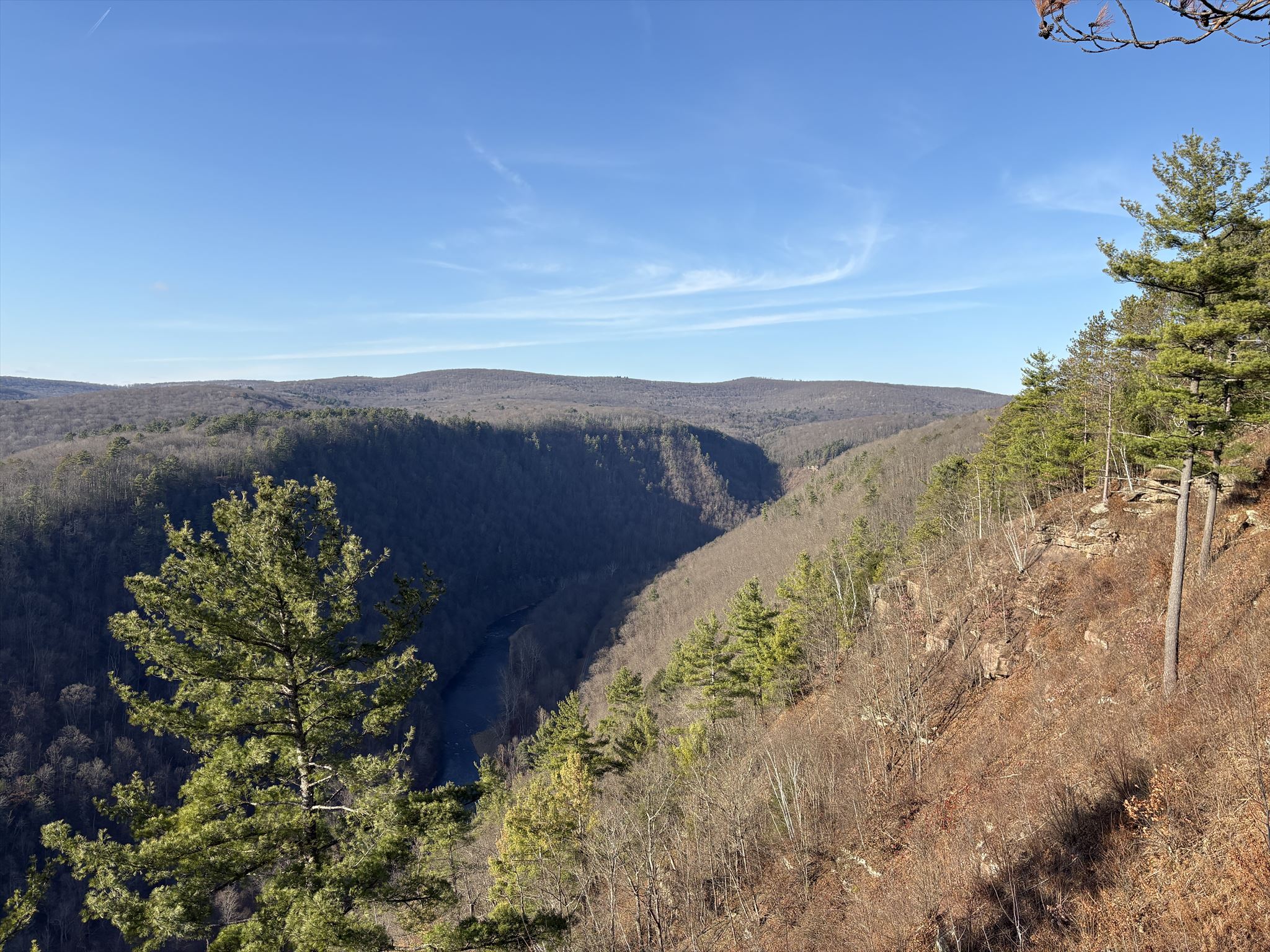
LHR-GT #08: Pennsylvania Grand Canyon
Located in central Pennsylvania, Tioga County is home to the Pennsylvania Grand Canyon, also known as Pine Creek Gorge, a 50-mile-long natural landmark renowned for its dramatic vistas, forested cliffs, and winding waterways. The area offers a wide range of outdoor recreation, from hiking, biking, and camping to kayaking, fishing, and scenic overlooks that showcase the region’s seasonal beauty. Rich in natural history and outdoor heritage, Tioga County attracts adventurers, nature enthusiasts, and families alike, providing both exhilarating experiences and peaceful escapes within one of the state’s most iconic landscapes. Click here to learn more
TO CLAIM CREDIT FOR THIS CACHE, you will need to visit the posted coordinates and use the information below to make observations based on what you see. This is an earthcache, which means there is no physical container at the posted coordinates, but rather questions you need to answer to claim credit for the find. Please send me the answers to the three questions below and use the certitude to get your code word for your Lumber Heritage GeoTour passport.
Questions
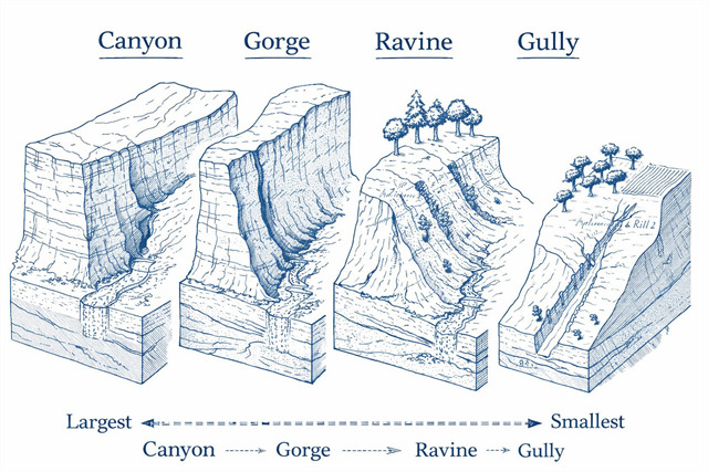
1. Do you think the formation at GZ more closely resembles a canyon, gorge, ravine, or gully? Please provide reasoning for your answer based on its characteristics and the readings on the cache page.
2. According to the nearby "Pine Creek" sign, how did this formation evolve to what you see today? (Hint: third paragraph) Is it U-shaped or V-shaped?
3. Observe the slopes and estimate the depth and angle to the best of your ability.
To get the code word for your passport locate the nearby sign titled "Pine Creek" and enter the nickname given to Pine Creek by the Indians.
In geomorphology—the study of how landscapes form and change—terms like canyon, gorge, ravine, and gully all describe valleys carved by erosion, but they differ in scale, shape, and how they form. Understanding these differences helps geologists interpret the history of water flow, rock strength, and landscape evolution.
Canyon
(Source)
A canyon is a large, deep valley with steep sides carved by a river cutting downward through rock layers over millions of years. Canyons are typically wider than gorges and often expose distinct rock strata that reveal Earth's geological history. A famous example is the Grand Canyon, carved by the Colorado River.
Key Traits: Very large valleys with steep walls, usually wider than gorges, formed by long-term river erosion and often exposing layered rock formations.
Gorge
(Source)
A gorge is a deep, narrow valley with very steep or nearly vertical sides, usually carved by fast-moving rivers cutting through resistant rock. Compared to canyons, gorges are more confined and often have a river occupying much of the valley floor.
Key Traits: Deep, narrow valleys with steep or vertical walls formed by rapid river downcutting through resistant rock.
Ravine
(Source)
A ravine is a smaller valley formed by erosion from running water, rainfall, or small streams. Ravines are common in wooded or hilly areas and may only carry water during heavy rain.
Key Traits: Smaller, steep-sided valleys created by runoff or small streams and often found in vegetated landscapes.
Gully
(Source)
A gully is a small channel formed when rainwater rapidly erodes soil, typically on slopes with little vegetation. Gullies can begin as shallow runoff channels but may grow larger if erosion continues.
Key Traits: Small, shallow erosion channels formed quickly by storm runoff, especially in exposed or disturbed soil.
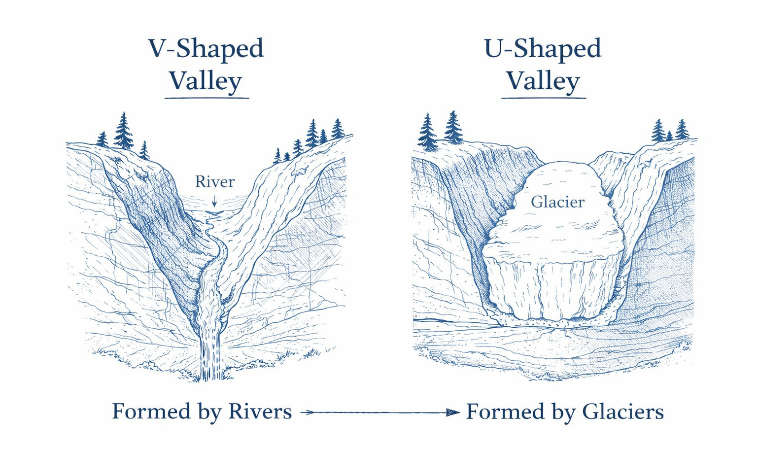
V-Shaped Valleys
(Source)
V-shaped valleys are formed primarily by river erosion. As a stream or river flows downhill, it cuts downward into the land, gradually deepening its channel. Weathering and small landslides cause material from the sides to fall into the river, which carries it away. Over time, this process creates a valley that is narrow at the bottom and slopes upward on both sides, forming a “V” profile when viewed in cross-section.
Key Traits: Narrow valley floors with sloping sides that meet at a river channel, created by long-term river erosion.
U-Shaped Valleys
(Source)
U-shaped valleys are formed by glacial erosion. Large glaciers move slowly through existing valleys, scraping and grinding the rock beneath them. Because glaciers are wide and powerful, they erode both the valley floor and the sides, widening and deepening the valley much more evenly than a river can. This creates a valley with a broad, flat floor and steep sides, producing a “U” shape in cross-section.
Key Traits: Wide valleys with flat floors and steep sides carved by the movement and erosion of glaciers.
Geology of the Pennsylvania Grand Canyon
(Source)
The Pine Creek Gorge, often called the Pennsylvania Grand Canyon, owes its dramatic landscape to the layered sedimentary rocks of the Allegheny Plateau. These rocks, primarily sandstone, shale, and siltstone, deposited during the Devonian Period, vary in hardness and erode at different rates. During the last ice age, powerful meltwater from glaciers greatly increased the flow of Pine Creek, allowing it to cut rapidly downward through the plateau. The combination of strong water erosion and layered rock created the steep, V-shaped valley seen today, where more resistant sandstone forms cliffs while softer shale weathers into slopes. This interaction between rock type and flowing water helps shape the deep valleys and rugged scenery that define the region.
This project was financed in part by a grant from the Community Conservation Partnerships Program, the Heritage Areas Program, under the administration of the Pennsylvania Department of Conservation and Natural Resources, Bureau of Recreation and Conservation.