français:
Gorges de Véroncle : La fête du Nouvel An de l’histoire de la Terre
Résumé
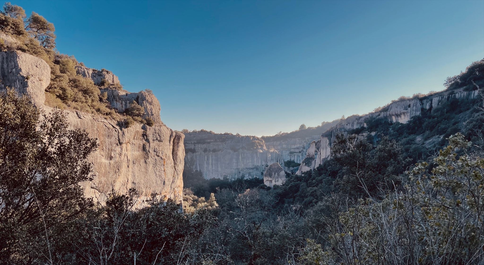
Entre Gordes et Murs, le petit ruisseau Véroncle s’est profondément incisé dans le plateau calcaire des Monts de Vaucluse, créant une gorge étroite d’environ 100 mètres de profondeur. L’EarthCache se trouve sur le bord occidental de cette gorge et offre une vue dégagée sur le vallon sinueux avec ses parois abruptes, ses bandes rocheuses et ses niches.
Avant de commencer
Deux itinéraires très différents mènent à l’EarthCache. Du plateau supérieur, vous accédez par des sentiers majoritairement caillouteux mais techniquement assez simples, d’environ trois kilomètres de long : du point de départ T0, suivez le sentier vers le point de référence R0 en montant, tournez à droite là-bas, puis à nouveau à droite à la prochaine occasion, jusqu’à atteindre l’EarthCache. L’itinéraire plus exigeant à travers la gorge commence à T0 sur la droite et mène, avec des passages d’escalade, des gués, un sol glissant et beaucoup de montées et descentes, jusqu’au point R1 en haut – une vraie sûreté de pied est indispensable ici. Cette voie est recommandée uniquement par temps sec ; en cas d’inondation, de fortes pluies ou d’orage, renoncez-y, car certaines sections peuvent devenir dangereuses. Chaussures solides, pied sûr et absence du vertige sont obligatoires, enfants uniquement avec expérience adéquate. Lampe et casque sont utiles pour visiter d’anciens moulins ou grottes, mais non nécessaires pour cet EarthCache.
Géologie des Gorges de Véroncle
La gorge se situe dans un vaste plateau calcaire, les Monts de Vaucluse, dont les roches proviennent principalement du Crétacé supérieur. Il y a 100 à 66 millions d’années, une mer chaude et peu profonde couvrait la région, où des coquilles, squelettes d’animaux marins et vase calcaire se sont déposés en épaisses couches de carbonate, qui se sont solidifiées en calcaire clair et cassant. Ces calcaires forment aujourd’hui la roche pâle et friable visible dans les parois de la gorge.
Au Tertiaire, la Provence s’est soulevée lors de la formation des Alpes et s’est fracturée en blocs. Le petit bassin de Murs s’est alors affaissé, surtout à l’Oligocène il y a environ 35 millions d’années, tandis que le bassin voisin d’Apt se trouvait à un niveau plus élevé. Le Véroncle a surmonté cette différence de niveau en s’incisant dans le bord du plateau ; les Gorges de Véroncle en sont le résultat et sont décrites dans la littérature française comme un « combre de raccordement », un canyon de liaison entre deux marches du relief.
La gorge mesure au total environ 7,5 kilomètres ; dans la zone de l’EarthCache, les parois atteignent environ 100 mètres de hauteur. Contrairement aux grands canyons de plateau comme le Grand Canyon aux États-Unis, le Véroncle ne draine qu’un petit bassin versant, expliquant pourquoi il est profond mais très étroit. Sa section transversale montre une incision abrupte, presque en forme de boîte, dans les bancs calcaires massifs. L’eau de pluie s’infiltre par des failles, absorbe du CO₂ de l’air et du sol, devient acide et dissout chimiquement le calcaire – surtout dans les zones fissurées ou moins compactes. En hiver, le gel accentue cela : l’eau pénètre dans les fines fissures, gèle, se dilate et fait éclater de petits blocs qui s’accumulent en éboulis au pied des pentes. Ainsi se sont formées, au fil des millénaires, des bandes rocheuses en gradins et des niches semi-circulaires, appelées localement « baumes ».
Le panneau d’information sur place illustre cela dans un schéma : l’eau de pluie s’infiltre par les failles, dissout le calcaire, creuse de petites cavités qui s’élargissent en niches visibles, jusqu’à ce que de gros blocs se détachent et que la paroi recule. Vous pouvez observer ce processus dans le profil rocheux en face, en prêtant attention aux transitions entre bancs compacts, couches plus tendres et bandes d’éboulis.
Temps et échelle – un regard au-delà du cadre
Pour situer les dimensions temporelles, un coup d’œil mondial sur d’autres gorges aide. Dans le Grand Canyon en Arizona, les roches les plus anciennes remontent à environ 1,7 milliard d’années, tandis que de nombreux sédiments visibles datent de 550 à 250 millions d’années. Pourtant, le Colorado n’a creusé le canyon actuel, profond de plus de 1,6 kilomètre, que principalement au cours des 5 à 6 derniers millions d’années, une phase géologiquement jeune.
Le Fish River Canyon en Namibie montre un contraste similaire : socle de granites et gneiss protérozoïques pouvant dépasser un milliard d’années, tandis que le canyon s’est formé en plusieurs phases depuis le Paléozoïque tardif et a acquis sa forme actuelle au Cénozoïque par érosion profonde sous climat sec.
Le canyon du Yarlung Tsangpo au Tibet, l’un des plus profonds de la Terre, a creusé une gorge extrêmement profonde en quelques millions d’années dans des roches soulevées rapidement par l’Himalaya.
Le canyon de Colca au Pérou atteint des profondeurs impressionnantes jusqu’à environ 3 kilomètres, et des études géochronologiques indiquent que sa forme actuelle date surtout du Cénozoïque tardif, pendant les phases intenses de soulèvement des Andes.
Plus proches, les Gorges du Verdon en Provence sont géologiquement similaires à Véroncle : calcaires mésozoïques marins, dans lesquels le Verdon s’est incisé de 700 mètres de profondeur au cours des 5 à 6 derniers millions d’années.
Les Gorges de Véroncle jouent dans une ligue plus modeste en termes d’ampleur, mais suivent les mêmes principes. Leurs calcaires du Crétacé supérieur sont nettement plus jeunes que les roches de base du Grand Canyon ou du Fish River, datant de quelques dizaines de millions d’années. Le canyon de liaison s’est développé depuis l’Oligocène, accéléré par les alternances humides et sèches du Quaternaire au cours des 2,5 derniers millions d’années.
Si l’on imagine les 4,6 milliards d’années d’histoire de la Terre comme une année calendaire, les calcaires du Luberon se forment en « novembre », les grands canyons mondiaux comme le Grand Canyon, le Verdon ou ceux du Tibet et du Pérou se sculptent fin « décembre », et la forme actuelle des Gorges de Véroncle émerge en substance lors des dernières heures du réveillon.
Homme et gorge – utilisation historique
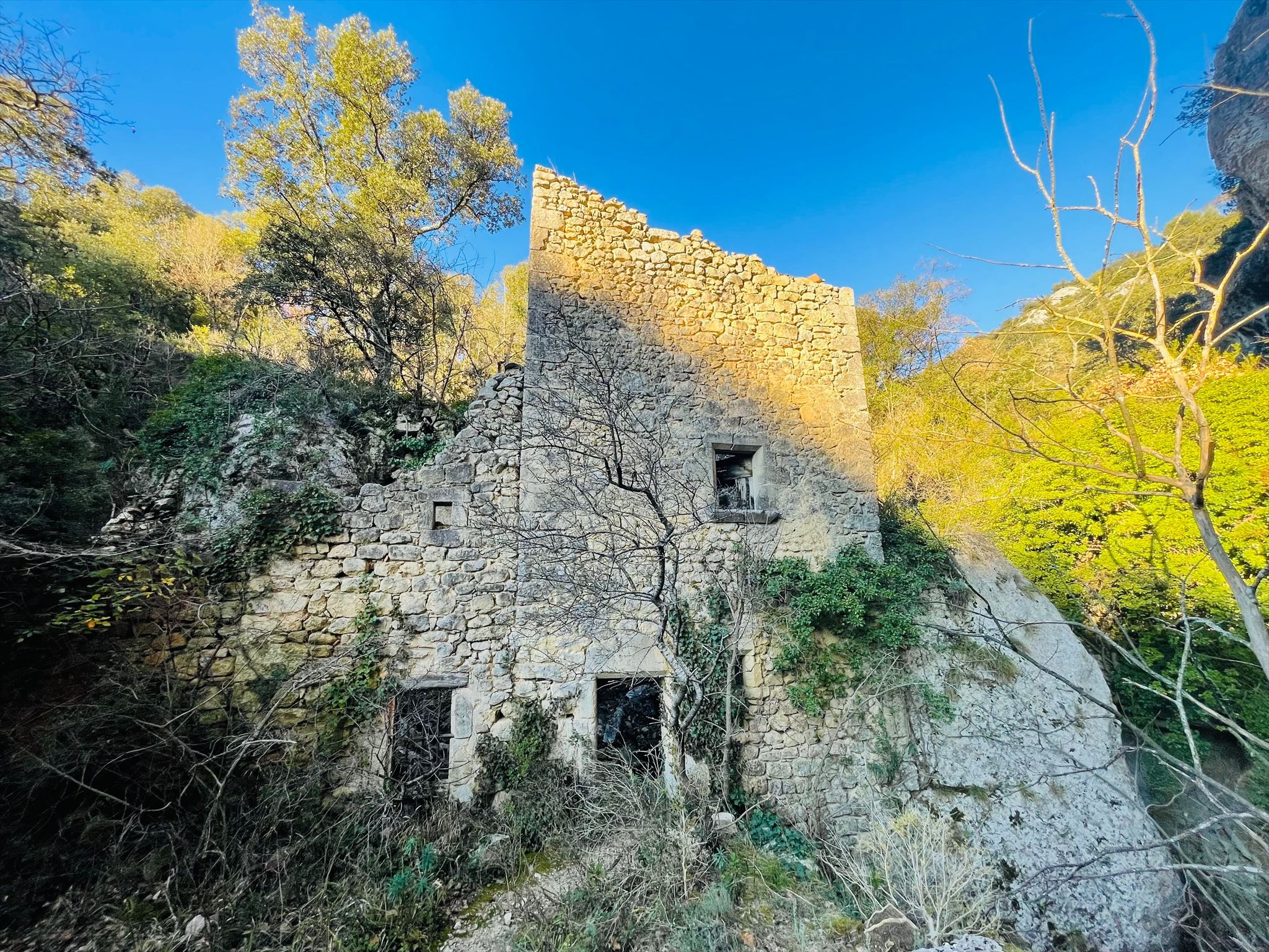
La gorge de Véroncle n’est pas seulement un archive géologique, mais aussi culturel. Le long du ruisseau s’alignent les ruines d’environ dix moulins historiques (comme Le moulin Cabrier / GC4DJK1 et Le moulin de Jean de Marre / GC4DKZR), en activité entre le XVIe et le XIXe siècle. Pour les alimenter, des barrages, canaux et chutes artificielles dirigeaient l’eau de la Véroncle vers les roues – une utilisation impressionnante des dénivelés naturels pour l’époque. Du grain aux lourdes meules, le matériel était transporté par sentiers étroits dans le vallon étroit ; exploitation du bois, pâturages et murs en pierres sèches ont laissé d’autres traces. Le panneau à l’EarthCache aborde cette dimension historique et explique comment l’utilisation a diminué au fil du temps, tandis que le canyon est resté un espace naturel préservé.
Tâches (Conditions de log)
Il n'y a pas de boîte de conserve sur place. Pour valider cet EarthCache, répondez sur place aux questions suivantes et envoyez vos réponses par message. Gardez vos observations courtes mais compréhensibles ; photos optionnelles, sans montrer les textes du panneau de manière lisible. Loguez cette cache "Found it" et envoyez-moi vos propositions de réponses soit via mon profil, soit via la messagerie geocaching.com (Message Center), et je vous contacterai en cas de problème
A) Questions de compréhension de la description
1. Estimez à partir de la fiche le âge des calcaires dans lesquels s’est formée les Gorges de Véroncle, et comparez avec l’âge des roches les plus anciennes du Grand Canyon. Formulez comme un rapport, par exemple : « Les roches les plus anciennes du Grand Canyon sont environ … fois plus vieilles que les calcaires du plateau de Véroncle. »
2. Expliquez en vos propres mots ce qu’est un canyon de liaison (« combre de raccordement ») et pourquoi les Gorges de Véroncle en font partie.
B) Questions sur place au panneau « Le Grand Méandre »
3. À droite du panneau, un schéma montre comment l’eau de pluie forme une « baume » dans le calcaire. Décrivez en vos propres mots au moins trois étapes de ce processus – de l’infiltration de l’eau à la dissolution chimique du calcaire, la formation d’une niche visible et l’effondrement ultérieur de blocs.
Le versant nord ou sud de la formation rocheuse devant toi semble-t-il plus propice à la formation de baumes? Les baumes se trouvent-ils sur les deux versants, dans la partie supérieure, centrale ou inférieure?
4. Dans la colonne centrale (« Un paysage façonné par l’homme »), l’utilisation historique de la zone est décrite. Quelles activités sont mentionnées et quel impact ont-elles eu sur le paysage ? Citez au moins deux exemples avec leur effet respectif.
5. Observez à la fois la gorge réelle et le profil schématique du panneau. Quelle est la forme générale de la section transversale ici – plutôt en V, en boîte ou en U – et les parois paraissent-elles abruptes ou déjà plus arrondies à votre poste ? Justifiez par une brève observation sur place.
C) Tâche volontaire, non obligatoire pour le log
6. Prenez une photo de vous, de votre GPS ou d’un objet personnel avec la gorge en arrière-plan, sans rendre lisibles les textes du panneau. Cela crée une petite collection d’impressions des Gorges de Véroncle.
allemand:
Gorges de Véroncle: Silvester-Party der Erdgeschichte
Zusammenfassung
Zwischen Gordes und Murs hat sich der kleine Bach Véroncle tief ins Kalksteinplateau der Monts de Vaucluse geschnitten und eine schmale, bis etwa hundert Meter tiefe Schlucht geschaffen. Die Koordinaten des Earth‑Caches liegen am westlichen Rand dieser Schlucht und bieten einen freien Blick in das gewundene Tal mit seinen steilen Wänden, Felsbändern und Nischen.
Bevor es losgeht
Zum Earth Cache führen zwei sehr unterschiedliche Wege. Von oben kommst du über ein Plateau, auf meist steinigen, aber technisch relativ einfachen Pfaden von rund drei Kilometern Länge. Folge dazu vom Trail Head T0 aus dem Pfad zum Referenzpunkt R0 bergauf, biege dort rechts ab und bei nächster Möglichkeit wieder rechts bis du den Earth Cache erreichst. Für den Weg durch die Schlucht halte dich am Trailhead T0 rechts und durchwandere die Schlucht bis zum Referenzpunkt R1, von wo aus du den oberen Rand der Schlucht erreichst. Diese Route ist wesentlich ansprechender, aber auch anspruchsvoller. Es gibt Kletterstellen, Wasserquerungen, rutschigen Untergrund und viel Auf und Ab – hier ist echte Trittsicherheit gefragt. Der Weg durch die Schlucht ist nur bei trockenen Verhältnissen und stabilem Wetter zu empfehlen. Bei Hochwasser, Starkregen oder Gewitter solltest du auf die Tour verzichten, weil einzelne Passagen dann gefährlich werden können. Festes Schuhwerk, ein sicherer Tritt und Schwindelfreiheit sind Pflicht, Kinder nur mit entsprechender Erfahrung. Eine Lampe und ein Helm können sinnvoll sein, wenn du zusätzlich alte Mühlenanlagen oder Höhlen besuchen willst, sind aber für diesen Earth Cache nicht zwingend nötig.
Geologie der Gorges de Véroncle
Die Schlucht liegt in einem großen Kalksteinplateau, den Monts de Vaucluse, dessen Gesteine überwiegend aus der Oberkreide stammen. Vor etwa 100 bis 66 Millionen Jahren lag hier ein warmes, flaches Meer, in dem sich Schalen und Skelette von Meerestieren und Kalkschlamm zu mächtigen Schichten aus Karbonat ablagerten, die später zu festem Kalkstein verfestigt wurden. Diese Kalksteine bilden heute das helle, spröde Gestein, das du in den Wänden der Schlucht siehst.
Zu Beginn des Känozoikums, im Tertiär, wurde die Provence im Zuge der Alpenbildung angehoben und in Blöcke zerlegt. Dabei entstand unter anderem das kleine Becken von Murs, das vor allem im Oligozän vor rund 35 Millionen Jahren einsank, während das benachbarte Apt‑Becken auf einem anderen Höhenniveau lag. Das Wasser musste dieses Gefälle zwischen den beiden Becken überwinden und begann, sich in den Rand des Plateaus einzugraben – die Gorges de Véroncle sind das Ergebnis dieses Vorgangs und werden in der französischen Literatur als „combre de raccordement“, also als Verbindungscanyon zwischen zwei Reliefstufen, beschrieben.
Die Schlucht ist insgesamt etwa siebeneinhalb Kilometer lang; im Bereich des Earth‑Caches erreichen die Wände Höhen von ungefähr hundert Metern. Im Gegensatz zu riesigen Plateaucanyons wie dem Grand Canyon in den USA entwässert die Véroncle jedoch nur ein relativ kleines Einzugsgebiet, was erklärt, warum der Canyon zwar tief, aber sehr schmal ist.
Der Querschnitt der Schlucht zeigt einen steilen, fast kastenförmigen Einschnitt in die massigen Kalkbänke. Das Regenwasser versickert über Klüfte im Kalk, nimmt Kohlendioxid aus der Luft und aus dem Boden auf und wird dadurch leicht sauer. Dieses Wasser löst den Kalk chemisch an und vergrößert Risse und Spalten, besonders dort, wo der Fels stark geklüftet oder etwas weniger kompakt ist. Im Winter kommt Frostsprengung dazu: Wasser dringt in feine Risse ein, gefriert, dehnt sich aus und sprengt kleine Brocken aus dem Gestein, die dann als Schutt am Hang landen. So entstanden im Laufe von Jahrtausenden gestufte Felsbänder und halbrunde Nischen, die in der Region „baumes“ genannt werden.
Die Infotafel vor Ort zeigt in einer Skizze, wie Regenwasser über Klüfte nach unten sickert, Kalk löst, kleine Hohlräume bildet und diese Hohlräume nach und nach zu einer erkennbaren Nische vergrößert, bis schließlich größere Blöcke abbrechen und die Wand zurückweicht. Genau diesen Prozess kannst du im Felsprofil gegenüber gut beobachten, wenn du auf die Übergänge zwischen kompakten Bänken, weicheren Lagen und Schuttbändern achtest.
Zeit und Maßstab – der Blick über den Tellerrand
Um die zeitlichen Dimensionen einzuordnen, hilft ein weltweiter Blick auf andere Schluchten. Im Grand Canyon in Arizona reichen die ältesten Gesteine bis etwa 1,7 Milliarden Jahre in die Vergangenheit, während viele der sichtbaren Sedimentgesteine zwischen 550 und 250 Millionen Jahre alt sind. Der Colorado River hat den heutigen, mehr als 1,6 Kilometer tiefen Canyon jedoch vor allem in den letzten fünf bis sechs Millionen Jahren eingeschnitten, also in einem geologisch relativ jungen Abschnitt.
Der Fish‑River‑Canyon in Namibia zeigt einen ähnlichen Kontrast: Der Untergrund besteht aus proterozoischen Graniten und Gneisen, die mehr als eine Milliarde Jahre alt sein können, während der eigentliche Canyon in mehreren Phasen seit dem späten Paläozoikum entstand und seine heutige Form im Känozoikum durch weitere Tiefenerosion unter trockenem Klima erhielt.
Der Yarlung‑Tsangpo‑Canyon in Tibet gilt als einer der tiefsten Canyons der Erde; dort schneidet sich ein großer Hochgebirgsfluss im Umfeld des Himalaya in rasch gehobene Gesteine ein und hat in wenigen Millionen Jahren eine extrem tiefe Schlucht geschaffen.
Der Colca‑Canyon in Peru erreicht ähnlich gewaltige Tiefen von bis zu rund drei Kilometern, wobei geochronologische Studien zeigen, dass der heutige Canyoncharakter vor allem im späten Känozoikum während starker Hebungsphasen der Anden entstanden ist.
Die nicht weit entfernten Gorges du Verdon in der Provence sind geologisch näher an der Véroncle: Auch hier handelt es sich um mesozoische Meereskalke, in die sich der Fluss Verdon in den letzten etwa fünf bis sechs Millionen Jahren bis zu rund siebenhundert Meter tief eingeschnitten hat.
Die Gorges de Véroncle spielen, was die Ausmaße angeht, in einer kleineren Liga, folgen aber denselben Grundprinzipien. Ihre Oberkreide‑Kalke sind im Vergleich zu den tiefsten Gesteinen von Grand Canyon und Fish‑River‑Canyon deutlich jünger und liegen im Bereich von einigen Dutzend Millionen Jahren. Der eigentliche Verbindungscanyon hat sich seit dem Oligozän entwickelt, und besonders die wechselnden feuchten und trockenen Klimaphasen des Quartärs in den letzten 2,5 Millionen Jahren haben dafür gesorgt, dass der Bach sich immer tiefer in das Plateau einschnitt.
Wenn man die 4,6 Milliarden Jahre Erdgeschichte als ein Kalenderjahr denkt, entstehen die Kalksteine des Luberon etwa im „November“, die großen globalen Canyons wie der Grand Canyon, der Verdon oder auch die tiefen Schluchten in Tibet und Peru werden im „späten Dezember“ geformt, und die heutige Gestalt der Gorges de Véroncle bildet sich im Prinzip in den letzten Stunden von Silvester heraus.
Mensch und Schlucht – historische Nutzung
Die Véroncle‑Schlucht ist nicht nur ein geologisches, sondern auch ein kulturhistorisches Archiv. Entlang des Baches reihen sich die Ruinen von etwa zehn historischen Mühlen (an Le moulin Cabrier / GC4DJK1 und Le moulin de Jean de Marre / GC4DKZR kommst du vorbei), die zwischen dem 16. und 19. Jahrhundert in Betrieb waren. Um sie zu versorgen, wurden Staumauern, Kanäle und Gefälle künstlich geschaffen, die das Wasser der Véroncle auf die Mühlräder leiteten – für die damalige Zeit eine beeindruckende Nutzung der natürlichen Höhenunterschiede in der Schlucht. Für den Betrieb der Mühlen musste Material – vom Getreide bis zu schweren Mühlsteinen – über schmale Pfade in das enge Tal transportiert werden. Holznutzung, Weidewirtschaft und der Bau von Trockenmauern hinterließen zusätzliche Spuren in der Landschaft. Die Infotafel am Earth‑Cache‑Punkt greift diese historische Dimension auf und erklärt, wie die Nutzung im Laufe der Zeit abnahm, während der Canyon selbst als naturnaher Landschaftsraum bestehen blieb.
Aufgaben (Logging Requirements)
Vor Ort gibt es keine Dose zu finden. Um diesen Earth Cache loggen zu dürfen, musst du die folgenden Fragen vor Ort beantworten und deine Antworten per Nachricht schicken. Halte deine Beobachtungen kurz, aber nachvollziehbar; Fotos sind freiwillig, dürfen aber die Texte der Infotafel nicht lesbar zeigen. Logge diesen Cache als „Found it“ und sende mir deine Antwortvorschläge entweder über mein Profil oder über die Nachrichtenfunktion von geocaching.com (Message Center). Bei Problemen werde ich mich mit dir in Verbindung setzen.
A) Verständnisfragen aus der bisherigen Beschreibung
1. Schätze anhand des Listings ab, wie alt die Kalksteine sind, in denen sich die Gorges de Véroncle gebildet haben, und vergleiche dies mit dem Alter der ältesten Gesteine im Grand Canyon. Formuliere deine Antwort als Verhältnis, zum Beispiel: „Die ältesten Gesteine im Grand Canyon sind ungefähr …‑mal so alt wie die Kalksteine des Véroncle‑Plateaus.“
2. Erkläre in eigenen Worten, was mit einem Verbindungscanyon („combre de raccordement“) gemeint ist und warum die Gorges de Véroncle diesem Typ zugeordnet werden.
B) Fragen vor Ort an der Infotafel „Le Grand Méandre“
3. Auf der rechten Seite der Tafel wird in einer Skizze gezeigt, wie Regenwasser eine „Baume“ im Kalkstein bildet. Beschreibe mit deinen eigenen Worten mindestens drei Schritte dieses Prozesses – vom Eindringen des Wassers über die chemische Lösung des Kalks bis zur Ausbildung einer sichtbaren Nische und dem späteren Abbruch von Blöcken.
Scheint der Nord- oder Südhang der Felsformation vor dir eher für die Bildung von Höhlen („Baume“) geeignet zu sein? Befinden sich die Höhlen in beiden Hängen im oberen, mittleren oder unteren Teil?
4. In der mittleren Spalte der Tafel („Un paysage façonné par l’homme“) wird die historische Nutzung des Gebietes beschrieben. Welche Tätigkeiten werden genannt und welchen Einfluss hatten sie auf die Landschaft? Nenne mindestens zwei Beispiele, und beschreibe kurz den jeweiligen Effekt.
5. Betrachte sowohl die reale Schlucht als auch das schematische Profil auf der Tafel. Welche grobe Form hat der Querschnitt hier – eher V‑förmig, kastenförmig oder U‑förmig – und wirken die Wände an deinem Standort eher steil oder bereits stärker abgerundet? Begründe deine Einschätzung mit einer kurzen Beobachtung vor Ort.
C) Freiwillige Aufgabe, kein Log‑Kriterium
6. Mache ein Foto von dir, deinem GPS oder einem persönlichen Gegenstand mit der Schlucht im Hintergrund, ohne die Texte der Infotafel lesbar zu zeigen. So entsteht eine kleine Sammlung von Eindrücken aus der Gorges de Véroncle.
Anglais:
Gorges de Véroncle: New Year's Eve Party of Earth's History
Summary
Between Gordes and Murs, the small Véroncle stream has carved deeply into the limestone plateau of the Monts de Vaucluse, creating a narrow gorge up to about a hundred meters deep. The coordinates of the Earth-Cache are located at the western edge of this gorge and offer a free view into the winding valley with its steep walls, rock bands, and niches.
Before You Start
There are two very different routes to the Earth Cache. From above, you reach it over a plateau on mostly stony but technically relatively easy paths about three kilometers long. To do this, follow the path from Trail Head T0 to reference point R0 uphill, turn right there, and then right again at the next opportunity until you reach the Earth Cache. For the route through the gorge, keep right at Trailhead T0 and hike through the gorge to reference point R1, from where you reach the upper edge of the gorge. This route is much more appealing but also more demanding. There are climbing sections, water crossings, slippery ground, and a lot of up and down – real surefootedness is required here. The route through the gorge is only recommended in dry conditions and stable weather. In case of high water, heavy rain, or thunderstorms, you should skip the tour because individual passages can become dangerous. Sturdy footwear, a sure step, and a good head for heights are mandatory; children only with corresponding experience. A lamp and helmet can be useful if you want to visit the old mill facilities or caves in addition, but they are not absolutely necessary for this Earth Cache.
Geology of the Gorges de Véroncle
The gorge is located in a large limestone plateau, the Monts de Vaucluse, whose rocks mainly date from the Upper Cretaceous. About 100 to 66 million years ago, a warm, shallow sea lay here, in which shells and skeletons of marine animals and limestone mud were deposited in thick layers of carbonate, which later solidified into solid limestone. These limestones form the light, brittle rock that you see in the walls of the gorge.
At the beginning of the Cenozoic, in the Tertiary, the Provence was uplifted and broken into blocks as part of the Alpine formation. This created, among other things, the small Murs basin, which mainly sank in the Oligocene about 35 million years ago, while the neighboring Apt basin was at a different elevation. The water had to overcome this gradient between the two basins and began to incise into the edge of the plateau – the Gorges de Véroncle are the result of this process and are described in French literature as a "combre de raccordement," or connecting canyon between two relief levels.
The gorge is about seven and a half kilometers long in total; in the area of the Earth-Cache, the walls reach heights of about a hundred meters. Unlike huge plateau canyons like the Grand Canyon in the USA, the Véroncle drains only a relatively small catchment area, which explains why the canyon is deep but very narrow.
The cross-section of the gorge shows a steep, almost box-shaped incision into the massive limestone beds. Rainwater seeps through fissures in the limestone, absorbs carbon dioxide from the air and soil, and thereby becomes slightly acidic. This water chemically dissolves the limestone and enlarges cracks and fissures, especially where the rock is strongly fractured or somewhat less compact. In winter, frost wedging is added: water penetrates fine cracks, freezes, expands, and breaks small pieces out of the rock, which then end up as debris on the slope. Over millennia, this created stepped rock bands and semicircular niches called "baumes" in the region.
The information board on site shows in a sketch how rainwater seeps downward through fissures, dissolves limestone, forms small cavities, and gradually enlarges these cavities into a recognizable niche until larger blocks break off and the wall recedes. You can observe this process well in the rock profile opposite if you pay attention to the transitions between compact beds, softer layers, and debris bands.
Time and Scale – Looking Beyond the Plate
To put the temporal dimensions into perspective, a global look at other gorges helps. In the Grand Canyon in Arizona, the oldest rocks date back about 1.7 billion years, while many of the visible sedimentary rocks are between 550 and 250 million years old. However, the Colorado River has incised the current, more than 1.6 kilometer deep canyon mainly in the last five to six million years, in a geologically relatively young period.
The Fish-River-Canyon in Namibia shows a similar contrast: The basement consists of Proterozoic granites and gneisses that can be more than a billion years old, while the actual canyon formed in several phases since the late Paleozoic and acquired its current form in the Cenozoic through further deep erosion under a dry climate.
The Yarlung-Tsangpo-Canyon in Tibet is one of the deepest canyons on Earth; there a large mountain river cuts into rapidly uplifted rocks in the Himalayan environment and has created an extremely deep gorge in just a few million years.
The Colca-Canyon in Peru reaches similarly enormous depths of up to about three kilometers, with geochronological studies showing that the current canyon character mainly formed in the late Cenozoic during strong uplift phases of the Andes.
The nearby Gorges du Verdon in Provence are geologically closer to Véroncle: Here too, it involves Mesozoic marine limestones into which the Verdon River has incised up to about 700 meters deep in the last five to six million years.
The Gorges de Véroncle play in a smaller league in terms of dimensions but follow the same basic principles. Their Upper Cretaceous limestones are much younger compared to the deepest rocks of the Grand Canyon and Fish-River-Canyon, in the range of a few dozen million years. The actual connecting canyon has developed since the Oligocene, and especially the alternating wet and dry climate phases of the Quaternary in the last 2.5 million years have ensured that the stream has incised deeper and deeper into the plateau.
If one thinks of the 4.6 billion years of Earth's history as a calendar year, the limestones of the Luberon form around "November," the large global canyons like the Grand Canyon, the Verdon, or the deep gorges in Tibet and Peru are shaped in "late December," and the current form of the Gorges de Véroncle essentially forms in the last hours of New Year's Eve.
Humans and Gorge – Historical Use
The Véroncle gorge is not only a geological but also a cultural-historical archive. Along the stream, the ruins of about ten historical mills line up (you pass Le moulin Cabrier / GC4DJK1 and Le moulin de Jean de Marre / GC4DKZR), which operated between the 16th and 19th centuries. To supply them, dams, canals, and artificial gradients were created that directed the water of the Véroncle to the mill wheels – for that time, an impressive use of the natural elevation differences in the gorge. For the operation of the mills, material – from grain to heavy millstones – had to be transported into the narrow valley over narrow paths. Wood use, pasture farming, and the construction of dry stone walls left additional traces in the landscape. The information board at the Earth-Cache point addresses this historical dimension and explains how usage declined over time, while the canyon itself remained as a near-natural landscape space.
Tasks (Logging Requirements)
There is no container to find on site. To log this Earth Cache, you must answer the following questions on site and send your answers via message. Keep your observations short but comprehensible; photos are optional but must not make the texts of the information board legible. Log this cache as "Found it" and send me your answer suggestions either via my profile or the geocaching.com messaging function (Message Center). In case of problems, I will contact you.
A) Understanding questions from the previous description
1. Based on the listing, estimate how old the limestones are in which the Gorges de Véroncle have formed, and compare this with the age of the oldest rocks in the Grand Canyon. Formulate your answer as a ratio, for example: "The oldest rocks in the Grand Canyon are approximately …-times as old as the limestones of the Véroncle plateau."
2. Explain in your own words what a connecting canyon ("combre de raccordement") means and why the Gorges de Véroncle are assigned to this type.
B) Questions on site at the "Le Grand Méandre" information board
3. On the right side of the board, a sketch shows how rainwater forms a "baume" in the limestone. Describe in your own words at least three steps of this process – from the penetration of the water through the chemical dissolution of the limestone to the formation of a visible niche and the subsequent breakage of blocks.
Does the north or south slope of the rock formation in front of you seem more suitable for the formation of caves ("baume")? Are the caves located in both slopes in the upper, middle, or lower part?
4. In the middle column of the board ("Un paysage façonné par l’homme"), the historical use of the area is described. Which activities are mentioned and what influence did they have on the landscape? Name at least two examples and briefly describe the respective effect.
5. Look at both the real gorge and the schematic profile on the board. What rough shape does the cross-section have here – rather V-shaped, box-shaped, or U-shaped – and do the walls at your location appear rather steep or already more rounded? Justify your assessment with a brief on-site observation.
C) Voluntary task, not a logging criterion
6. Take a photo of yourself, your GPS, or a personal item with the gorge in the background, without making the texts of the information board legible. This creates a small collection of impressions from the Gorges de Véroncle.