Mullaghmeen
At 258m, but a nice prominence of 146m, this small hill is the 1254th highest mountain on the island of Ireland - and the county top for Westmeath. It is the second lowest county top, with with only Slieve Na Calliagh/Loughcrew in Meath boasting a lesser elevation.
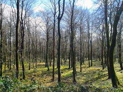
Mullaghmeen is an isolated area of forest rising above the farm land of north Westmeath. Mullaghmeen Forest is the largest planted beech forest in Ireland. Along with beech, within its 400 ha of forest it also has Sitka spruce, Scots pine and noble fir and a very interesting native tree collection. Sadly, the forest was very severely damaged by Storm Eowyn in January 2025 - so the southern face of the hill is carnage. Nontheless, this is well worth a stop on the Mullaghmeen Summit Trail / Red Trail. The summit of Mullaghmeen used to provide magnificent views north across Lough Sheelin and into the neighbouring county of Cavan, but mother nature's forest has grown high enough to obscure it now - so, this is the view you are missing!

Lough Sheelin View in April 2016 - sadly no longer visible
The forest, once an out farm belonging to a Lord Gradwell, has many examples of mans former impacts on the landscape. Following the White Trail one passes sad reminders of famine times with relic walls of famine fields. A Booley Hut, a summer grazing shelter is just off the Red Walk / Mullaghmeen Summit Trail, while the Flax Pits show that this important crop for the linen industry was once harvested and cured in this area. The underlying Geology is Limestone Rock and in the south eastern corner more of its geology is revealed where one can see turloughs - disappearing lakes that fill and empty with no apparent in or outflow. Come in spring for the best displays of woodland flowers notably bluebells. The area is populated with grey squirrels, jays, badgers, foxes, pheasant, rabbit & hares as well as a large selection of song birds. The area has an extensive network of way marked trails for varying levels of fitness. Source: Coillte Outdoors.
 |
 |
| Springtime Forest View |
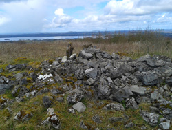
Summit Cairn |
Mountainviews.ie listing is here!
The Cache
The cache is small waterproof PET tube, placed only a few meters from the summit cairn. While the forest tracks are in good condition and are eminently walk-able, the ascent to the summit is on a steep, muddy - and potentially slippery - track, so stout walking boots are a must and walking poles may suit some. I can recommend a looped walk, ascending on the west side and descending to the east which will allow you to take in the famine works on the return to the parking waypoint.
Leave No Trace
|

|
The cache has been placed in accordance with the "Leave No Trace" principles.
Please respect these principles when searching for the cache. The cache location is in woodland under management by Coillte.
|
