+
English (Deutsches Listing unten)
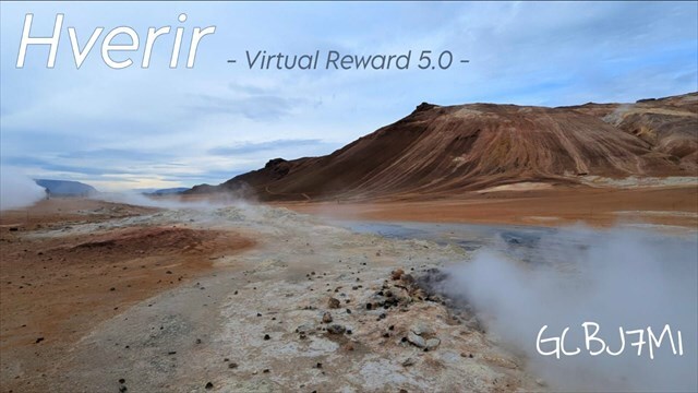
Welcome to the fascinating Hverir geothermal area, one of Iceland's most spectacular natural wonders! Here, hot springs, bubbling mud pots, and steaming fumaroles meet a lunar-like landscape characterized by mineral deposits and vibrantly colored soils.
Located in northern Iceland at the foot of Mount Námafjall, near Lake Mývatn, this area is renowned for its geothermal activity, which has captivated researchers, travelers, and photographers for centuries.

Highlights of Hverir
-
Mud pots: boiling and bubbling in different sizes and fascinating movements. Sometimes you can almost hear them "panting"!
-
Steam columns: Impressive clouds of steam rise from the hot ground, particularly impressive in the cool morning hours.
-
Coloured soils: The earth here displays intense colours from yellow to red to orange and brown – a vibrant mosaic of minerals.
-
Scent: A strong, "earthy" scent accompanies the geothermal activity and is reminiscent of the raw power of nature. 濫☺️
Tips for your visit:
-
Safety first: Please always stay on the marked paths! Temperatures here sometimes reach 80-100°C.
-
Best time for photos: Early morning or towards evening, when the steam looks particularly mystical.
-
Equipment: Sturdy footwear, weatherproof clothing and a camera for breathtaking shots
Tasks:
To log this cache, you must complete the following tasks:
1. Visit: the Hverir geothermal area at the listed coordinates.
2. Identify: Are mainly mud pots or furmaroles visible within a 25-meter radius?
3. Identify: Which mineral causes the yellowish color on the ground?
4. Log photo: Take at least one funny picture of yourself with the mud pots or steam vents in the background, or "stage" them, and attach it to your onlinelog (Your faces don't necessarily have to be visible.).
(Alternatives: a photo taken at the location with a piece of paper on which your geocaching name is written! "Boring")
Please submit your answers to tasks 2 and 3 via the cache's message center before logging your find (Please indicate if you are answering for multiple accounts!).
You don't need to wait for a reply and can log your find immediately! Don't forget your photo(s) ;)
Have fun exploring! - RonnyEdMan 落落

Deutsch (English listing up)
Willkommen am faszinierenden Geothermalgebiet Hverir, einem der spektakulärsten Naturwunder Islands! Hier treffen heiße Quellen, brodelnde Schlammtöpfe und dampfende Fumarolen auf eine mondähnliche Landschaft, die von mineralischen Ablagerungen und farbenprächtigen Böden geprägt ist.
Dieses Gebiet liegt im Norden Islands am Fuße des Berges Námafjall nahe dem Mývatn-See und ist bekannt für seine geothermische Aktivität, die seit Jahrhunderten Forscher, Reisende und Fotografen gleichermaßen in Staunen versetzt.

Highlights von Hverir
-
Schlammtöpfe: Kochen und blubbern in unterschiedlichen Größen und faszinierenden Bewegungen. Manchmal hört man sie fast „schnaufen“!
-
Dampfsäulen: Aus dem heißen Boden steigen imposante Dampfwolken auf, besonders beeindruckend in den kühlen Morgenstunden.
-
Farbige Böden: Die Erde hier zeigt intensive Farben von gelb über rot bis hin zu orange und braun – ein lebendiges Mosaik aus Mineralien.
-
Geruch: Ein kräftiger, "erdiger" Geruch begleitet die geothermische Aktivität und erinnert an die rohe Kraft der Natur. 濫☺️
Tipps für euren Besuch
-
Sicherheit geht vor: Bleibt bitte immer auf den markierten Wegen! Hier herschen teilweiße Temperaturen von 80 - 100°C.
-
Beste Zeit für Fotos: Früh morgens oder gegen Abend, wenn der Dampf besonders mystisch wirkt.
-
Ausrüstung: Festes Schuhwerk, wetterfeste Kleidung und eine Kamera für die atemberaubenden Aufnahmen.
Aufgaben
Um diesen Cache zu loggen, müsst ihr folgende Aufgaben erfüllen:
1. Besuche: das Geothermalgebiet Hverir an den Listingkoordinaten.
2. Identifizieren: Im Umkreis von 25 Metern sind hauptsächlich Schlammtöpfe oder Furmarolen zu sehen?
3. Identifizieren: Welches Mineral verursacht die gelbliche Farbe am Boden?
4. Logfoto: Macht mindestens ein lustiges Bild von dir/euch mit den Schlammtöpfen oder Dampfsäulen im Hintergrund, oder setzt diese "in Szene" und hängt es eurem OnlineLog an (Eure Gesichter müssen nicht zwingend sichtbar sein).
(Alternative: ein Foto vor Ort mit mit einem Zettel auf dem euer Geocachname steht! "Langweilig" )
Die Antworten auf Aufgabe 2 & 3 bitte vor dem Loggen über das Nachrichten-Center des Caches einsenden (Bitte angeben, wenn ihr für mehrere Accounts antwortet!).
Ihr braucht nicht auf Antwort zu warten und könnt danach sofort loggen! Foto(s) nicht vergessen ;)
Viel Spaß beim Entdecken wünscht RonnyEdMan!落落

Für die Bannerfreunde/ for the banner friends:
Link fürs Profil: <a href="http://coord.info/GCBJ7M1"; target="_blank"><img src="https://s3.amazonaws.com/gs-geo-images/548e7c20-ff34-4a2d-9f74-ce5e80b09980_l.jpg"; width="300" height="175" " ></a>

Virtual Rewards 5.0 - 2026-2027
This Virtual Cache is part of a limited release of Virtuals created between February 3, 2026 and February 3, 2027. Only 4,000 cache owners were given the opportunity to hide a Virtual Cache. Learn more about Virtual Rewards 5.0 on the Geocaching Blog.