L'éléphant de Chausey
Rappel concernant les Earthcaches :
Il n'y a pas de conteneur à rechercher ni de logbook à signer. Après avoir été sur les lieux pour chercher les réponses aux questions, loguez cette cache "Found it" et envoyez-moi vos propositions de réponses, en précisant le code GC de la cache, soit via mon profil, soit via la messagerie geocaching.com (Message Center), et je vous contacterai en cas de problème.
Attention, l'earthcache n'est pas forcément accessible à marée haute ! Pensez à consulter les horaires de marées avant de venir sur place.
Questions :
1- Sur le côté de l’éléphant, les diaclases sont horizontales ou verticales ?
2- Comment les éléments marins font évoluer les diaclases ?
3- L’élargissement des diaclases est centimétrique, décimétrique ou métrique ?
Descriptif de l'earthcache
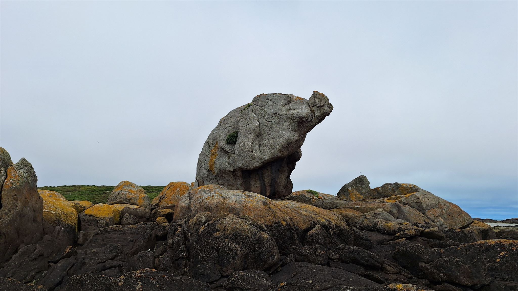
Situées à l'entrée de la Baie du Mont-Saint-Michel, à une quinzaine de kilomètres au Nord-Ouest de Granville, les Îles Chausey constituent un archipel, principalement caractérisé par un marnage très important pouvant atteindre 14 mètres. A marée haute, on dénombre 52 d’îles émergées, mais à marée basse, on dénombre 365 îles ou îlots.
Contexte géologique locale
La roche dominante des îles Chausey est une granodiorite gris-bleu, isogranulaire, appartenant au batholite tardi-cadomien de la Mancellia. Elle présente localement une texture planaire orientée, soulignée par l'alignement d'enclaves surmicacées. La roche est composée de 53.5% de feldspath, 31% de quartz et 14.5% de biotite. L'altération de cette granodiorite est à l'origine de chaos granitiques bien dégagés en bord de mer, présentant de nombreuses formes aux noms évocateurs, comme l'éléphant ou les moines. Connue sous le nom de "granite de Chausey", cette granodiorite a par ailleurs été activement exploitée dès le XIe siècle et jusqu'à la fin du XIXe siècle, notamment pour la construction de l'abbaye du Mont-Saint-Michel.
Diaclases et chaos granitique
Les diaclases sont des fractures naturelles affectant les massifs rocheux sans déplacement des blocs. Dans le granite, elles se forment lors du refroidissement du magma en profondeur, puis s'élargissent sous l'effet de l'altération chimique : l'eau chargée de dioxyde de carbone s'y infiltre et transforme progressivement les feldspaths en argiles.
En milieu maritime, ces processus sont amplifiés par les cycles de marée, qui introduisent l'eau de mer dans les fractures, et par la cristallisation du sel lors des phases de séchage, qui écarte progressivement les parois. Au fil du temps, cet élargissement continu des diaclases finit par isoler des blocs individuels, de plus en plus arrondis et détachés du massif rocheux. Les formes arrondies et irrégulières des blocs qui composent les chaos granitiques invitent naturellement à la paréidolie, l'œil humain y distingue spontanément des visages ou des silhouettes animales.

The Chausey elephant
Reminder about Earthcaches:
There are no containers to search or logbooks to sign. Once you've been to the site to look for the answers to the questions, log this cache “Found it” and send me your suggested answers, specifying the cache's GC code, either via my profile or via geocaching.com (Message Center), and I'll contact you if there's a problem.
Please note that the earthcache is not necessarily accessible at high tide! Be sure to check the tide tables before you arrive.
Questions :
1- On the side of the elephant, are the joints horizontal or vertical?
2- How do marine elements cause the joints to change?
3- Is the widening of the joints measured in centimetres, decimetres or metres?
Earthcache description
Located at the entrance to the Bay of Mont-Saint-Michel, some fifteen kilometres north-west of Granville, the Chausey Islands form an archipelago characterised primarily by a very significant tidal range of up to 14 metres. At high tide, there are 52 islands above water, but at low tide, there are 365 islands or islets.
Local geological context
The dominant rock of the Chausey Islands is a grey-blue, isogranular granodiorite belonging to the Late Cadomian Mancellia batholith. Locally, it exhibits an oriented planar texture, emphasised by the alignment of surmicaceous enclaves. The rock consists of 53.5% feldspar, 31% quartz and 14.5% biotite. The weathering of this granodiorite has given rise to clearly defined granite boulders along the coast, featuring numerous formations with evocative names, such as ‘the elephant’ or ‘the monks’. Known as ‘Chausey granite’, this granodiorite was also actively quarried from the 11th century right through to the end of the 19th century, notably for the construction of Mont-Saint-Michel Abbey.
Joints and granitic chaos
Joints are natural fractures that occur in rock masses without any displacement of the blocks. In granite, they form as magma cools at depth, and then widen as a result of chemical weathering: water laden with carbon dioxide seeps into them and gradually transforms the feldspars into clays.
In a marine environment, these processes are amplified by tidal cycles, which draw seawater into the fractures, and by the crystallisation of salt during drying phases, which gradually pushes the walls apart. Over time, this continuous widening of the diaclases eventually isolates individual blocks, which become increasingly rounded and detached from the rock mass. The rounded and irregular shapes of the boulders that make up the granite chaos naturally invite pareidolia; the human eye spontaneously recognises faces or animal silhouettes in them.