Riding at Beaver Lake back in "The Day"
Back in the '80s and early '90s, Beaver Lake (a.k.a. "The Beav", "Section 36" or "Soaring Eagle Park") was a premier destination for local mountain bikers. A virtual maze of singletrack criss-crossed through the area from Redmond-Fall City Road almost all of the way to 228th Ave. NE, with tendrils reaching north toward the Redmond Watershed and south all the way to Tiger Mountain.
The picture is much different today. The bulk of the trails have disappeared beneath bulldozers and business parks. The beautiful beaver pond seen along one of the better routes through the area is now a water hazard for a golf course. Housing developments have bitten off huge chunks from around the edges of the system. A third of the remaining area is slated to be turned into ball fields as soon as the City of Sammamish and King County can come up with the funds.
This multicache is designed to lead you through the beautiful remnants of this once-expansive network of trails before they are gone. You can expect to spend roughly 2 to 4 hours (on bike) or 3 to 5 hours (on foot) on this outing. The distance traveled will be approximately 6 to 9 miles depending on how successful you are at navigating the maze of trails. It is possible to cut some of the distance off by driving from trailhead to trailhead to get as close as possible to the waypoints, but you probably won't save that much time and will miss much of what this area has to offer. Elevation gain is minimal, but there are some hills in the area. As with any forest setting, signal can sometimes be difficult to come by, so come prepared with the hints and spoiler pics. Each of the waypoints is either hidden next to the trail, or within a handful of yards in relatively open ground cover, so you shouldn't have to do much bushwhacking.
This cache involves 4 "minicaches" (Army decon boxes measuring 4" x 3" x 2") and a final cache consisting of a .30-cal. ammo can. Each of the minicaches contains a pair of numbers needed to complete the coordinates for the final cache.
The four minicaches are named for each of the cardinal directions and can be found in any order. They are located at the following coordinates:
| South: |
N 47° 36.082', W 121° 59.377' |
| East: |
N 47° 36.396', W 121° 58.399' |
| West: |
N 47° 36.286', W 121° 59.519' |
| North: |
N 47° 36.839', W 121° 58.950' |
Inside each minicache you will find an insert like this:
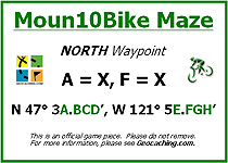
Plug the numbers on the insert into the appropriate spots in the following set of coordinates to arrive at the location of the final cache:
N 47° 3A.BCD', W 121° 5E.FGH'
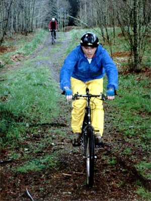
I hope that you enjoy exploring this remnant of a once-great trail network. Although these trails are just a shadow of their previous glory, they are still wonderful and are still quite popular with mountain bikers. You can expect to encounter bikes year-round on the trails, so keep an eye out around blind corners and remember to step off the trail when a bike comes by.
Thanks to Whidbey Walk for the inspiration for this cache, and thanks to the mountain bikers who have built and maintained these trails over the years.
Map of Soaring Eagle Park