At each of the waypoints you will collect numbers to fill in the puzzle. When complete the final cache location coordinates will be revealed. The waypoints can be visited in any order, although we suggest you do them in sequence.
W.P.#1 N44° 42.800' W063° 40.249'
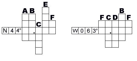
To fill in column A: What year was the photograph taken?
W.P.#2 N44° 43.774' W063° 39.652'
To fill in column B: What year was the railway built?
To fill in column C: What year did the barracks burn?
To fill in column D: What year was the fort built?
W.P.#3 N44° 45.115' W063° 39.827'
To fill in column E: What year is represented on the center plaque?
W.P.#4 N44° 45.084' W063° 39.763'
To fill in column F: How many countries are represented excluding Canada?
To find the final cache, take a seat. Cache is a bison tube containing only a log sheet. Bring a writing instrument. It should take you roughly 1 hour over a distance of 7.5 km, mostly driving. Parking is available near all the waypoints. If you are not familiar with the area it may take a while to find the right roads.
Checksum N 21 W 36
Fill in this puzzle to find the final coordinates
This cache owner
supports the
Association of Nova Scotia Geocaching