This cache is placed with permission. Please follow all park rules, noting that the park is open Dawn to Dusk (no night caching, please).
Cell service will be limited in various areas on the AMNHA Geo-Path. Please plan accordingly.
Questions or need to share a challenge with a cache?
Send us a message through the Geocaching app
Remember to bring a pen, items to trade, and follow recommended
Geocaching Etiquette
.
CONGRATULATIONS TO DOUGS94 AND LINDA, NIGHTWING AND PROZAC FOR BEING THE FTF!

AMNHA Geo-Path Series
AMNHA: Pole Bridge Creek Cascades
Passport:
Geo-Path
Series: Past and Present Passages
Password: Located in the logbook
Hours: Sunrise to Sunset
Parking Options: See waypoints (paid or free)
AMNHA and the U.S. National Parks GeoTour
This geocache is part of the AMNHA Geo-Path and also qualifies for the
U.S. National Parks GeoTour (GT6A). It is one of a small number of caches in the Arabia Mountain National Heritage Area that connects both programs, linking a local landscape of granite outcrops, creeks, and cultural history with a nationwide GeoTour experience.
If you are using the Geocaching app, tap the GeoTour button on this cache page to view GeoTour details and track your progress, or use the link below.
View the U.S. National Parks GeoTour (GT6A)

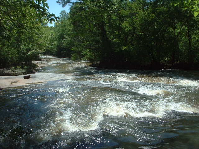
Pole Bridge Creek: A Hidden Gem
Pole Bridge Creek is one of those places that surprises you. A quiet stretch of water, tucked into the trees, suddenly opens into small cascades and falls that feel miles away from everything.
In 2004, many glass bottles were found along the creek, a reminder that people spent time here long ago. For a while, the spot faded from memory. Today, it is still a bit of a “hidden” location, and part of the fun is that it feels like you discovered it.
Getting There
To find the geocache, park on Evans Mill Road. The parking area, finished in late 2004, is at the western end of the Flat Rock Spur, a part of the Arabia Mountain PATH Trail.
The trail to the waterfalls and geocache starts about 100 feet east of the parking lot. Look for orange marks on the trees to stay on the trail as you head toward the cascades.
Explore the Area
When you’re done with the geocache, you can walk east along the bike trail for about 1.5 miles to see the covered bridge over Stephenson Creek.
You can also follow the Cascades Hiking Trail, which connects to the bike trail, and then continue east to the bridge.
The bridge is 55 feet long and is often attributed to Horace King, a formerly enslaved bridge builder known for covered bridges across the South in the 1800s.
As you walk, you’ll see old trees that have been here since the early 1900s, when people lived in this area.
Evans Mill
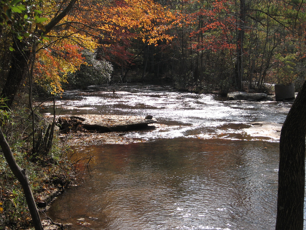
Before you leave, take a short hike to see the ruins of Evans Mill, which was built in the late 1800s. There’s a trail that leads to a moss-covered rock wall, the remains of a dam that once held water for the mill. This trail starts at the parking lot entrance.
Along the way, you’ll pass a tree with a trunk that grows sideways. From some rocks by the creek, you can get a great view of the waterfalls. On the other side of the creek, you can spot more parts of the old dam and a stone channel that carried water to the mill.
The mill was located near the south end of the dam, at the foot of the cascades. The sign near the site might be a little confusing about the mill’s location. The pond behind the dam filled with mud over time, and the mill stopped working. Now, picnic tables sit on top of the sediment left behind.
In the early 1930s, the mill was repaired and a new dam was built upstream. A turbine and generator were added to provide electricity to the mill, a nearby store, and the mill owner’s home. The mill was abandoned in the late 1940s. Over time, only the remains of the two dams, the stone channel, and part of the mill’s machinery remain.
Imagine the Past
As you look at the creek today, try to imagine what it looked like more than 100 years ago, when the mill was still working and the area was full of life.
About the Arabia Mountain National Heritage Area (AMNHA)
The Arabia Mountain National Heritage Area is a unique landscape just east of Atlanta, known for its beautiful granite outcrops and rich history. Spanning over 40,000 acres, it includes not only the stunning Arabia and Panola Mountains but also former quarries, agricultural sites, historic communities, and spiritual centers.
The area has a deep history, from Native American settlements to European settlers and enslaved Africans. Arabia Mountain was once a major granite quarry that supplied stone for structures like the U.S. Naval Academy. Panola Mountain, however, was spared from quarrying and remains a pristine natural space with rare plants and wildlife.
Today, visitors can explore hiking, biking, and nature trails, and discover historic sites like Vaughters' Farm and the Flat Rock community, one of Georgia’s oldest African-American communities. The Monastery of the Holy Spirit, a peaceful retreat, is also located here.
Popular Trails in the Area:
• Arabia Mountain Top Trail (1.3 miles) – A beginner-friendly trail leading to 360-degree views at the summit.
• Mile Rock Trail and Forest Trail Loop (2 miles) – A scenic loop through forests and granite expanses, passing a picturesque lake.
• Arabia Mountain View Trail (2.3 miles) – A trail through shaded forests, open rock areas, and grassy meadows.
• Cascade Trail and Wilburn Farm Trail (3.25 miles) – A scenic loop that passes waterfalls and historic barn ruins.
• Arabia Mountain Boardwalk Trail Loop (5.1 miles) – The park’s most scenic trail, featuring forests, Arabia Lake, and panoramic mountain views.
The AMNHA offers a peaceful escape from the city, with opportunities for outdoor adventures and a deeper connection to Georgia’s natural and cultural history.
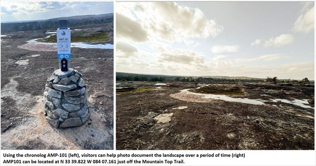
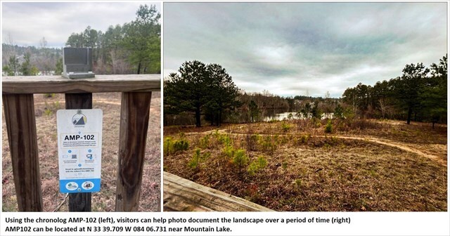
Capturing Change Over Time
You may notice Chronolog stations near Arabia Lake and other points along the trail. These stations invite visitors to take a photo from a fixed location, helping document how the landscape changes over time. Seasonal shifts, weather, wildlife, and human impact all become part of a growing visual record created by the people who explore this place.
Are You Ready to Find More Geocaches?
Come explore the
Arabia Mountain PATH
and earn trackable prizes along the way.
The
AMNHA Geo-PATH
is a geocaching program spread across more than 30 miles of the Arabia Mountain PATH hike and bike trail.
Many geocaches are waiting to be discovered.
Download the passports
Geocaching Adventures Passport
Each cache is classified into one of the following series:
• Adventure Labs
• Arabia Mountain Adventures
• Geocaching 101
• GeoTour
• Lands Less Visited
• Lithonia's Historic Hike
• Panola Mountain Pathways
• Past and Present Passages
• South River Stroll
Completed the passports?
Choose one of the following options to claim your prize:
Scan and email the Arabia Alliance Team
Scan and mail to the Arabia Alliance office
Additional Links
Trail Maps and
Landmarks
Learn and
Activities
Tips for Hiking in the Summer Heat
Tips for Avoiding Ticks
Winter Hikes and Winter Wildlife
Waypoints and
Adding or Viewing Coordinates
Trails Map Type Option