This is the third in a series of eight earthcaches being developed at major points of interest in Newberry National Volcanic Monument in cooperation with the staff of the Deschutes National Forest. This earthcache is located along a nearly one mile paved/crushed rock trail with stairs. As you walk the interpretive trail you will find a series of seven signs which discuss the geology, archaeology, cultural history, and biology of the flow.
To claim this Earthcache you need to post a photo(s) of your favorite view(s) along the trail and email me the answers to the following questions:
- At the stairway up onto the flow how thick (to nearest foot) is the flow? Assume each step is 7” high. Do not use the thickness on the nearby sign, it is an estimated average thickness, I want the thickness at the stairway.
- Title of sign at N 43° 42.288’ W 121° 14.135’
- Title of sign at N 43° 42.197’ W 121° 14.146’
- Using your GPS what is the distance and heading (from True North) from the highest viewpoint (at the A Special Place on the Planet sign) to the edge of the flow (at the A Glass Menagerie sign).
While doing this earthcache you may also be able to collect the necessary information to claim several waymarks in the area.
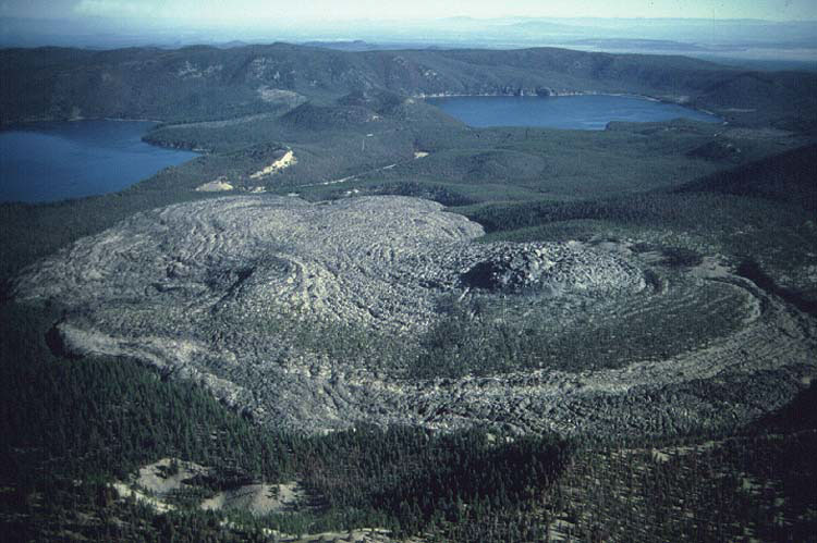 The Big Obsidian Flow is the most recent eruption from Newberry Volcano. About 480 A.D. (1,470 calendar years B.P.), a 3-part sequence of rhyolitic eruptions began, which included an air-fall tephra, ash-flow tephra, and an obsidian flow, from a common vent at the base of the south caldera wall.
The initial Plinian eruption 480 A.D. (1,580 C14 yrs B.P.) produced the Newberry pumice fall deposit which blanketed the east flank of the volcano and areas to the east. About 200 yrs later the Paulina Lake ash flow (1,310 C14 yrs B.P.) spread from near the south caldera wall to Paulina Lake. The final phase of the eruption produced the Big Obsidian Flow which covers 2.8 sq km.
NOTE: Carbon-14 age-dates must be corrected to give calendar or actual year age-dates. Primarily because the production of C-14 in the atmosphere by cosmic rays is not uniform through time, age-dates derived from C-14 must be calibrated with known dates. Conversion from C-14 to calendar years is now possible throughout the range of 0 to 11,390 calendar years ago based on tree ring chronologies and other methods allow corrections back to almost 22,000 calendar years. C-14 age-dates are always referenced to the year 1950 A.D. Calendar year age-dates are likewise referenced to 1950.
The obsidian and pumice of this rhyolite lava flow contains about 73% silica (silicon dioxide) in comparison to the lava flows at Lava River Cave which only contain about 49% silica. The entire surface of this flow is glass (a liquid that cooled without crystallizing), the differences you see on the surface are due to the number and size of bubbles in the glass.
From the upper most view point the following features are visible:
| NORTH |
|
|
|
|
| |
N 15 E
|
-
|
1.3 mi
|
-
|
Central Pumice Cone -- 7,200 year old pumice cone between East and Paulina Lakes. |
| |
N 36 E
|
-
|
1.1 mi
|
-
|
Game Hut Obsidian Flow -- 7,200 year old from Central Pumice Cone |
| |
N 44 E
|
-
|
2.6 mi
|
-
|
East Lake (locational only - not visible) -- Maximum depth 180 feet |
| |
N 52 E
|
-
|
2.8 mi
|
-
|
Cougar Point on east caldera wall |
|
|
N 64 E
|
-
|
0.4 mi
|
-
|
East rim of Lost Lake Pumice Ring -- The west side and floor of this pumice ring have been covered by the Big Obsidian Flow. This view point is located near the probable location of the west rim. |
| |
N 82 E
|
-
|
1.4 mi
|
-
|
South Dome -- 12,000 year old rhyolite dome, source of tree covered obsidian flow which extends north to southwest corner of East Lake. |
| EAST |
|
|
|
|
| |
S 20 E
|
-
|
0.9 mil
|
-
|
Dome at vent for Big Obsidian Flow (locational only - not visible) -- 1,250 year old rhyolite dome. |
| SOUTH |
|
|
|
|
| |
S 44 W
|
-
|
1.3 mi
|
-
|
Paulina Peak -- Rhyolite dome which formed about 83,000 years ago, shortly before the large eruption which resulted in the formation of Newberry Crater |
| WEST |
|
|
|
|
| |
N 52 W
|
-
|
1.6 mi
|
-
|
Center of Paulina Lake -- Maximum depth 250 feet |
| |
N 50 W
|
-
|
30 mi
|
-
|
Mt. Bachelor -- Summit cone on shield volcano |
| |
N 44 W
|
-
|
38 mi
|
-
|
South Sister -- Composite volcano |
| |
N 41 W
|
-
|
41 mi
|
-
|
Top of Middle Sister -- Composite volcano |
| |
N 24 W
|
-
|
2.3 mi
|
-
|
Red Slide -- Cinder cone on north wall of caldera above Paulina Lake. |
| |
N 1 W
|
-
|
0.6 mi
|
-
|
High east rim of Little Crater -- Tuff ring |
| NORTH |
|
|
|
|