A brief introduction....
Welcome to Sheppardtown! This cache is a short tour of some sites of significance to Shepparton from a historic perspective. This cache was originally placed by djcache and is one of Shepparton's earliest caches, from memory it's earliest multi/puzzle cache. Now that djcache & family are now part of Shepparton's history too, it has been adopted by Cybergran V. The cache had survived in its original container, and location for more than a decade, but the container was recently moved so a new cache has been placed. While the final location is reasonavbly busy, it would be appreciated if you are very discrete retrieving it to help preserve this historic cache. Some structures and locations have changed over the life of this cache. Where necessary (location 5 & 6) additional information has been placed in the cache description, including photos, to assist with completing the puzzle.
From the SMH.com.au website (edited - I corrected their mistakes):
Shepparton (population 28 000) is the major centre of the Goulburn Valley and the headquarters of the Goulburn Valley irrigation system. It is located 179 km north of Melbourne on the Goulburn Valley Highway and 113 metres above sea-level. Mooroopna (population 5260) is separated from Shepparton by the river and a large tract of flood-prone forest and joined by a causeway. The surrounding area produces a substantial proportion of the state's agricultural output, particularly fruit, vegetables, cereals and milk products. Local industry includes two enormous fruit canneries (SPC and Ardmona, which which merged several years ago and were subsequently bought by Coca-Cola Amatil), Campbell's Soups and a famous foundry.
The area is thought to have been inhabited by the Yorta-Yorta people prior to white settlement. The first Europeans to venture onto the townsite were Joseph Hawdon and Charles Bonney who camped here by the Goulburn River while overlanding cattle from Albury to Adelaide.
In 1843 Sherbourne Sheppard took up the Tallygaroopna run on which the town later developed. The settlement was initially known as Macguire's after the man who established a punt service on the Goulburn for the diggers headed to the goldfields. Naturally he added an inn to lighten their pockets before the crossing. The name had been changed to Sheppardtown by 1855 when the first survey was conducted.
The village became a stopover for the paddlesteamer service which travelled along the Goulburn River to Echuca on the Murray River. Agriculture also developed at this time. Nonetheless there were only 30 recorded residents and a half-dozen buildings in 1871. Mooroopna was then the more important of the two settlements as its punt service attracted more custom from travelling diggers moving from the goldfields further west to new finds in the north east of the state, and those in Gippsland. A private township was established there in 1874. However, Shepparton developed rapidly with the arrival of the railway in 1880.
The Furphy foundry was opened by John Furphy in 1878. It was here that the famous Furphy water-cart was manufactured.
A major expansion of agricultural production and of the local population occurred after 1912 when irrigation really got under way with water from Lake Nagambie. Dairies and orchards proliferated after World War I, engendering a period of rapid growth. This led to the development of subsidiary industries such as milk processing, fruit packing and canning. Thus, in 1917, the Shepparton Preserving Company (SPC) was formed. Today it is one of the world's largest fruit canneries. Another major player is the Ardmona cannery in Mooroopna which opened in the 1920s. The two canneries which operated as co-operatives owned by the local growers merged several years ago to create SPC Ardmona. They have since been bought by Coca-Cola. Shepparton became a borough in 1927 and a city in 1949.
Cleckheaton Woollen Mill was established in 1948 in a transfer of operations from Leeds in England, but has since moved on as it merged with a company and moved operations to Wangaratta, and Campbell's Soups opened its factory in 1962.
|
Due to the shortsightedness of town planners of yesteryear most of Shepparton's historic buildings have been demolished to make way for the likes of the beauty (NOT) of the current post office. It no longer has the charm of the likes of Ballarat or Bendigo as a result.
As a town though it has many sites of both local and national historic significance. Unfortunately even most locals couldn't tell you the first thing about any of them. By the end of this cache you should know a little more about this interesting place. And through completing this cache you will have avoided doing what most do in Shepparton - stop for Maccas or KFC and keep driving.
The other thing that is a popular activity in Shepparton and is definately worth considering is a shopping trip to the SPC Factory Outlet in Shepparton.
The cache.....
The starting point for this cache, which will involve a short but easy walk, will find you south of the CBD. The whole cache should be able to be easily completed within an hour - particularly if you drive from point 1 to point 2 before parking.
To complete the cache you must answer some questions to determine the coordinates of the next location in your quest. At some points information will be required to complete the final coordinates. Collect the figure/letter substitutions highlighted in bold below to complete the cache as you go.
Location 1
At the location in question you will find a cairn commemorating a first for Shepparton.
Collect: The year on the plaque is ABCB.
At this location according to the plaque, Joseph Hawdon & Charles Bonney, the first white men to visit the area:
a) built the first building in Shepparton
b) camped here
c) operated the first dairy
d) discovered gold
| Coordinates for location 2 |
| A |
B |
C |
D |
S36° 22.970
E145° 24.015 |
S36° 22.790
E145° 23.875 |
S36° 22.560
E145° 23.900 |
S36° 22.760
E145° 23.786 |
Location 2
A recently constructed monument honours one of Shepparton's local identities of old. The Furphy name is famous, and is synonomous with the Australian language. The Furphy's of Shepparton gained their place in Australian language with the Furphy water cart and the adoption of the expression "a furphy" to mean a tall story. A little known fact though is that Joseph Furphy, brother of John (the foundary owner) made his own mark on Australian language and literature under the pen name, Tom Collins.
The famous Australian novel "Such is Life" was penned at this very spot. You will learn more of why Joseph chose to live here at another location in this cache. He now squats here permanently tending his billy, under the kurrajong & wilga trees he planted many years ago. To progress to location 3 you must answer the following using information obtained here.
Joseph was well travelled drover of:
a) the high country
b) the Barcoo
c) the Riverina
d) the Goulburn
| Coordinates for location 3 |
| A |
B |
C |
D |
S36° 22.790
E145° 23.875 |
S36° 22.796
E145° 23.858 |
S36° 22.737
E145° 23.888 |
S36° 22.773
E145° 23.899 |
Location 3
You will find yourself on a busy corner near a garden. The plaque is a dedication of the garden in the honour of a visitor/s:
Collect: The year of the visit in question is AEFG
The visitor/s was:
a) the Governer General & his wife
b) General MacArthur
c) Queen Elizabeth I
d) Queen Elizabeth II
| Coordinates for location 4 |
| A |
B |
C |
D |
S36° 22.710
E145° 23.455 |
S36° 22.796
E145° 23.785 |
S36° 22.690
E145° 23.555 |
S36° 22.696
E145° 23.877 |
Location 4
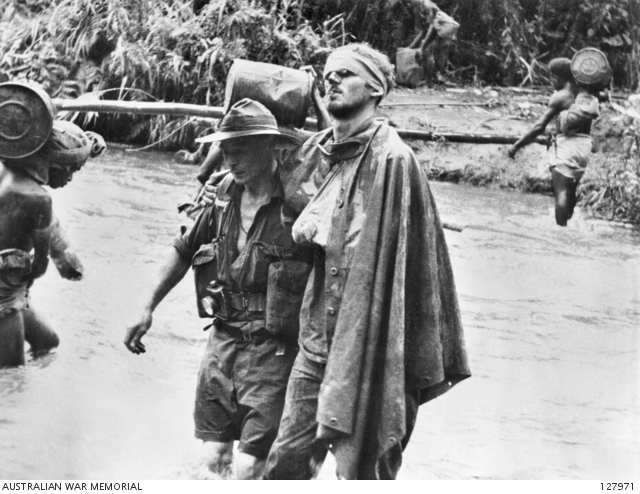
Still taken from Damien Parer news reel.
At this location you will find a 3 dimensional representation of a famous image from the middle of the last century. One of the people represented in that image was from Shepparton.
His name was:
a) Gordon
b) Peter
c) Damian
d) Wally
| Coordinates for location 5 |
| A |
B |
C |
D |
S36° 22.798
E145° 23.822 |
S36° 22.750
E145° 23.790 |
S36° 22.822
E145° 23.798 |
S36° 22.722
E145° 23.898 |
Location 5 (nearly there)
There was a time in the early 1980's where energy supply and it's future was being questioned. Alternative energy supplies were all the rage. Shepparton has long been known the Solar City, due to it's generally good weather all year round. This location was once an effort to highlight that point but it has long since lost it's steam. The meters that were installed on the structure showed that it provided less power for the fountain it was intended to power, than was required to run them. With modern day LED lighting that may not have been the case. In the days it was constructed solar panels were horrendously expensive, and this modest system that may now be found on a house roof in town, installed for a few thousand dollars, was the result of a joint project costing in excess of $100,000.
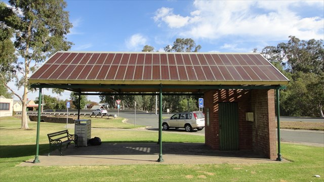
The structure has a number of cells making up the north facing roof. That number = FH (See photo in cache notes & images. Other answers required are now included in above text.)
The structure here was designed to power the:
a) Street lighting
b) Fountain
c) BBQ
d) Traffic lights
The structure here has produced:
a) more power than it's intended purpose required
b) less power than it's intended purpose required
Hint: look at the meters....
| Coordinates for location 6 |
| A & A |
B & B |
C & A |
D & B |
S36° 22.725
E145° 23.365 |
S36° 22.838
E145° 23.816 |
S36° 22.555
E145° 23.690 |
S36° 22.696
E145° 23.877 |
When getting to the next location you can pass under the busy Midland Hwy.
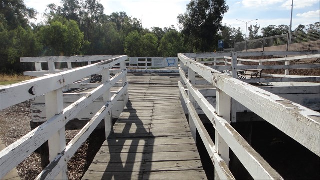
Location 6
All the rivers run, and some don't run where they used to. Not many realise that in the 10 years before the railway came to Shepparton in the mid-late 1800's much of Shepparton's freight arrived and departed on the Goulburn, by paddlesteamer & barge to & from the river port of Echuca.
A steamer wharf was constructed, and it is that on which you now stand. The river once ran past here, up the back of the offices which now harbour Joseph's memorial and on this side of the large gum tree which sits between the rose garden and the pond. It proceeded through the war memorial and continued on it's way. The wharf is now a popular spot for wedding photos, and not much else.
The path of the river and gradual erosion of the eastern bank threatened the town CBD so a few or 30 years ago it was realigned under the first bridge on the way to Mooroopna. The earth excavated was used to elevate the Midland Hwy between Shepparton & Mooroopna.
While you are here have a look around the rest of the historic displays. There are some fascinating facts. The museum is open on Sunday afternoons on the even Sunday's of the month.
Collect: The Goulburn River was realigned to it's current allowance in the construction of the western approach to Shepparton in AEHE-KL.
The signs here are hopefully going to be relocated soon to make life easier for cachers. In the mean time a good zoom lens, or a pair of binoculars would make the task of getting the next few pieces of the puzzle easier!
From the sign here, the bulk of the river trade occurred in:
a) Summer
b) Autumn
c) Winter
d) Spring
Nearby here there's a plinth. This structure was erected in ABGE.
| The management of the area are aware of and endorse the placement. Final cache location is at: |
| A |
B |
C |
D |
S36° DH.BAD
E145° CD.GHE |
S36° AA.EKL
E145° AD.HGE |
S36° LL.BHK
E145° LC.BFK |
S36° AE.HEK
E145° AA.ABD |