
 The western 3/4 of the island (west of Prisoner's
Harbor)is owned by The Nature Conservancy. Only people with
landing permits can go ashore. You can still enjoy this part
of the island from the sea.
The western 3/4 of the island (west of Prisoner's
Harbor)is owned by The Nature Conservancy. Only people with
landing permits can go ashore. You can still enjoy this part
of the island from the sea.
Dry caves are used by nesting seabirds. Do not enter any dry
cave. You may go into caves that are flooded and big enough to
easily accommodate your boat, but not the caves where you are
walking into the cave.
Many of the caves on Santa Cruz Island have formed in volcanic
rocks. Typically these rocks are relatively strong. However, in
order for erosional forces to create a cave, need to find some
point of weakness in the rock. These weak spots are along joints
and faults that have formed in the rock.
Joints are cracks in the rock that have formed from the rock
expanding after being buried, contracting while cooling down from
lava, or from being moved around. Essentially no movement occurs
across a joint, unlike a fault.
A fault is a crack in the rock along which the rocks move
relative to each other.
In either case, the resulting crack is a weak spot in the rock
where the waves are able to remove pieces of the rock faster than
in the surrounding rock. Thus caves form along these cracks.
Waves pound the cliff faces with hundreds of pounds of force per
wave eroding away the base of the cliffs. Where there are areas of
weakness, that portion of the cliff erodes forming indentations.
These indentations reinforce the erosion by focusing more energy
from each wave into the confined space creating caves.
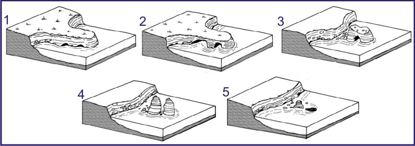 Continued erosion eventually erodes the
cliffs and caves down, sometimes isolating remanents of the
cliff off-shore in what are called sea stacks.
Continued erosion eventually erodes the
cliffs and caves down, sometimes isolating remanents of the
cliff off-shore in what are called sea stacks.
If you go to the coordinates, there are two caves to look at.
But again don't enter these.
Logging requirements:
Send me a note with :
- The text "GCZ5G2 Caves of Santa Cruz Island" on the first
line
- The number of people in your group.
- Post a picture with coordinates (as close as you safely can) of
a cave somewhere on the island.
- In your log be sure to describe the feature that helped form
the cave. If you are on a boat cruse, post the coordinates of where
the boat was and the name of the boat.
- Based on the sequense in the diagram, which number picture best
represents the geomorphology of the coastline at the
coordinates?
The above information was compiled from the
following sources:
-
http://en.wikipedia.org/wiki/Sea_caves
- Bird, E, 2008. Coastal Geomorphology: An
introduction. John Wiley and Sons, Ltd.
-
http://teacher.scholastic.com/lessonrepro/lessonplans/theme/caves04.htm
Placement approved by the
Channel Islands National Park