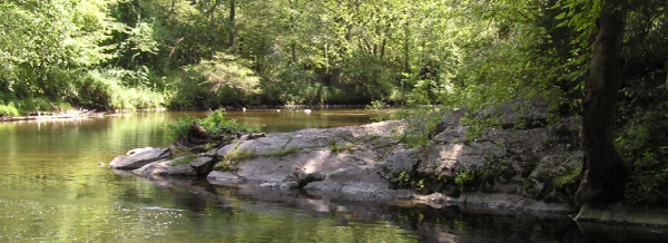
LOCATION: Haney’s Mill, Delaware Water Gap National
Recreation Area, New Jersey
ACCESSING THE TRAIL: Park in the small dirt lot just
south of the bridge over Flat Brook. You can see the Earthcache
location from the lot. Note: If you have a compass, bring it with
you. This is a popular fly-fishing spot; please be respectful of
your fellow outdoorsfolk.
A ROCKY RECORD OF ENVIRONMENTAL CHANGE
The presence of limestone at this Earthcache at Haney’s Mill,
not far from the sandstones and shales on neighboring Kittatinny
Mountain, is evidence of environmental changes that occurred in
this region over millions of years.
If you look up and to the west, you’ll see the crest and western
flank of Kittatinny Mountain. The rocks you see on Kittatinny
Mountain are older than the limestones in the outcrop in front of
you. The gray, white and red rocks on Kittatinny Mountain, called
sandstones and shales, formed from sediments that were deposited in
rivers and shallow marine environments. The light gray rocks where
you are standing, called limestones, formed under different
conditions, in the quieter waters of lagoons and intertidal
zones.
The gray sandstones are middle Silurian in age, approximately
430 million years old. They formed from quartz-rich sediments left
behind by fast-moving rivers that once flowed through the Taconic
Mountains. The Taconic Mountains were part of a mountain range that
once existed to the east and north of this site, but have since
eroded away.
During the late Silurian Period, the mountains continued to
erode. In the west, sea level rose and the shorelines slowly
encroached across western New Jersey. By this time, the topography
was very gentle and the rivers flowed more slowly (perhaps like
southern New Jersey today) but with an eroding mountain range to
the east. The overlying (and therefore younger) red sedimentary
rocks called shales formed in this type of gently-moving river and
shallow coastal environment.
Over several million years, conditions changed, and the
environment became more tranquil. Slow-moving rivers carried less
sand and clay to the coast, and the coastal waters became clear.
Slowly the type of sediment that formed in the marine waters
changed from river-supplied sand and clay to limestone formed by
marine critters. Limestone generally needs clear and calm waters to
develop. The limestone rocks here at Haney’s Mill shows evidence of
this environmental change.
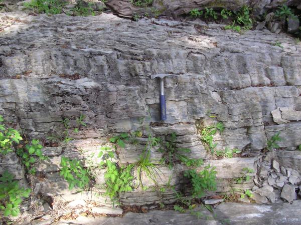
FOUR HUNDRED MILLION YEAR-OLD MUD CRACKS
The limestones are thinly-bedded to laminated (that is, even
more thinly-bedded), almost like the pages of a book. They are part
of what we call the Bossardville Limestone that is late Silurian
age, approximately 418 million years old. These limestones formed
in areas like a back lagoon or what we call the intertidal zone,
meaning between the tides. An intertidal zone is under water during
high tide but exposed during low tide.
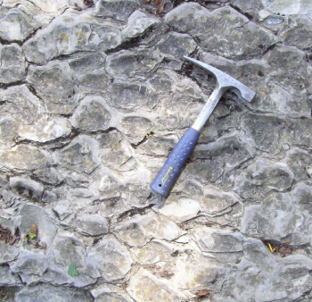 One bed at this site
shows what happened when this type of lime sediment underwent
repeated drying and re-wetting. The lime sediments behaved
much like mud behaves in a dried-up lakebed or on many
construction sites. After a rain, mud will shrink as it dries,
and cracks will form. These cracks will meet and intersect,
forming polygons of uncracked fine-grained clay material. The
mud-cracked polygons can be many-sided but tend to form
rounded shapes without any preferred orientation. In this
case, the sediment was not clay but rather very fine-grained
lime material.
One bed at this site
shows what happened when this type of lime sediment underwent
repeated drying and re-wetting. The lime sediments behaved
much like mud behaves in a dried-up lakebed or on many
construction sites. After a rain, mud will shrink as it dries,
and cracks will form. These cracks will meet and intersect,
forming polygons of uncracked fine-grained clay material. The
mud-cracked polygons can be many-sided but tend to form
rounded shapes without any preferred orientation. In this
case, the sediment was not clay but rather very fine-grained
lime material.
 Some of the layers
spent more time under water and less time above water, while a
few beds experienced more dry periods and periodic flooding
events. Here you can see a thick mud-cracked bed between two
thinly-bedded to laminated layers without mud cracks. This
shows that these three layers developed under different
environmental conditions. The uncracked top and bottom layers
were mostly wet; the mud-cracked middle layer was mostly dry.
Over time these sediments were buried and solidified into
rock.
Some of the layers
spent more time under water and less time above water, while a
few beds experienced more dry periods and periodic flooding
events. Here you can see a thick mud-cracked bed between two
thinly-bedded to laminated layers without mud cracks. This
shows that these three layers developed under different
environmental conditions. The uncracked top and bottom layers
were mostly wet; the mud-cracked middle layer was mostly dry.
Over time these sediments were buried and solidified into
rock.
These cracks are much thicker than normal cracks because the
process kept repeating. Here the cracked bed is close to 36 inches
thick. Each time the water covered this area it laid down new
sediment which then dried out and cracked after the tide went out.
In this way deeply-cracked sediment is formed; scientists call
these “prism cracks”. The term “prism cracks” is used because the
thick columns of mud-cracked sediment resemble prisms.
SAYS WHO??
Geologists learn how these types of deposits develop by studying
how they form in modern environments such as the Caribbean or
Florida. Study of prism cracks in modern environments revealed that
algae and bacteria play a part to help trap the new sediment. The
sediment is a lime mud that has been well-mixed by the burrowing of
different organisms.
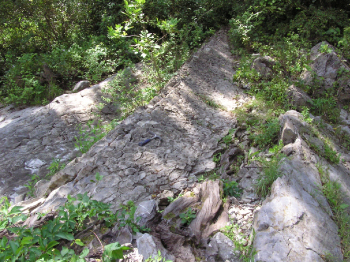
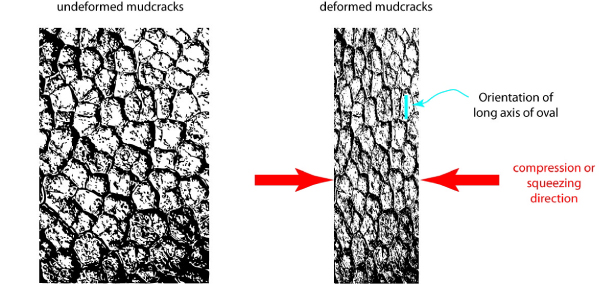
WHAT ELSE CAN WE LEARN FROM THE MUD CRACKS?
The second important aspect of this outcrop also has to do with
the mud cracks. As described above, mud cracks form roughly rounded
polygons. But the polygons here are not rounded but generally oval.
Therefore, these previously-rounded mud crack polygons have been
deformed; they have been squeezed into ovals. The important thing
to notice is that all the ovals are aligned, with the long axis of
each oval pointing in the same direction. (The “long axis” is the
direction that the long edge if the oval is pointing.) What could
have squeezed (or “compressed”) these features and in what
direction was the compression applied?
As we look at these and other surrounding rock layers we see
further evidence of pressure. The layers here are no longer
horizontal, as most intertidal zones are now. These beds now tilt
down towards the northwest. In addition, layers of rock up on
Kittatinny Mountain show signs of folding similar to what happens
if you push opposite sides of a piece of paper towards each other.
All of this deformation resulted from the collision of continents
on different tectonic plates. The tectonic plate collision that
compressed the rocks here occurred when all of the continents moved
together and formed the supercontinent named Pangaea, around 265
million years ago. When the North American plate collided with the
African plate, closing the ancestral Atlantic Ocean basin in the
process, a mountain range formed where the plates join. What’s left
of this old mountain range is the current Appalachian
Mountains.
These deformed polygons are evidence of a compressional event.
We can use the orientation of the long axis and the short axis of
the ovals to determine how the land was compressed at this
location. The long axis shows the direction of low pressure. The
short axis shows the direction in which pressure was applied. These
two directions are 90 degrees apart.
To claim this cache: Answer the following questions, and
post your answers in your log. Tell us how many people were in your
group. (You don't have to wait for a confirmation from us to claim
the cache. We trust you!)
1. What is the compass direction of the long axis of the
deformed mud cracks? (If you have a compass, tell me the compass
bearing. If not, just estimate the direction.) 2. Therefore, in
which direction was the pressure applied here when the African and
North American plates collided? Post a photograph of yourself or
your GPS receiver beside the mud-cracked outcrop.
REFERENCES
Dimicco, R.V., and Hardie, L.A., 1994, Sedimentary structures
and early diagenetic features of shallow marine carbonate deposits,
Society of Sedimentary Geology, SEPM Atlas Series no. 1, 265p.
Fischer, A.G., 1964, The Lofer Cyclothems of the Alpine
Triassic, in Merriam, D.F., editor, Symposium on cyclic
sedimentation: Kansas Geological Survey, Bulletin 169,
p.107-149.
This Earthcache is brought to you by the
NEW JERSEY GEOLOGICAL SURVEY
an agency of the New Jersey Department of Environmental
Protection.


Visit us at www.njgeology.org