Since many of us have found numerous caches along the Bruce
Trail and hence hiked on many parts of it, I figure it's time to
hike a complete section of the Bruce Trail. I have picked April 6th
as it's a holiday (Good Friday) and we'll have the nice long
weekend to recover from the event. Let's hope that the temperature
will be between 5° and 10°C and no rain to make it a perfect
day.
I estimate that the entire hike will take about 13 hours to
complete, so we should be done around 9pm. This is at a moderate
4km\h pace.
If you can't make the entire hike, maybe join us for part of it
atleast. You can always drop out along the way if you feel it's too
difficult or too long.
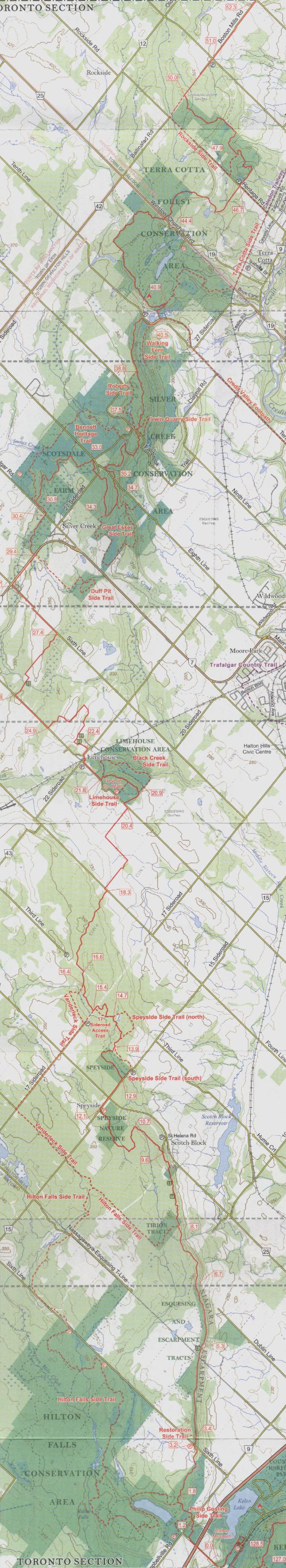
 Meet at 8am at the posted coordinates, which is along
Applyby Line just on the outside of the west end of Kelso
Conservation Area, about 100m north of the railroad tracks and
about 600m south of the 401 underpass.
Meet at 8am at the posted coordinates, which is along
Applyby Line just on the outside of the west end of Kelso
Conservation Area, about 100m north of the railroad tracks and
about 600m south of the 401 underpass.
 Destination
is the end point of the Toronto section of the Bruce Trail which is
at the corner of Creditview Rd and Boston Mills Rd in Caledon. (N43
45.835 W79 56.251)
Destination
is the end point of the Toronto section of the Bruce Trail which is
at the corner of Creditview Rd and Boston Mills Rd in Caledon. (N43
45.835 W79 56.251)
 Track
our progress as we hike the trail. Don't feel up for the hike, then
join us by watching our progress as we go along. Screen will update
every minute, but Keith will be updating our progress every 30
minutes and also when we meet and leave roads. Thanks to Keith
Watson for setting this up.
Track
our progress as we hike the trail. Don't feel up for the hike, then
join us by watching our progress as we go along. Screen will update
every minute, but Keith will be updating our progress every 30
minutes and also when we meet and leave roads. Thanks to Keith
Watson for setting this up.
Google Maps - http://www.ghcaching.com/maps/aprs_gm_map.php?calls=VA3UPL-G
Google Earth - http://www.ghcaching.com/maps/aprs_ge_start.php?calls=VA3UPL-G

 Parking:
It's probably best to park your car near the end point and get
someone to drop you off at the beginning location of the hike.
According to the Bruce Trail guide there is roadside parking
on Boston Mills Rd east of Mississauga Rd which is 1.3km west
of the ending point of the hike. I have also talked with the
Toronto BTA and they have said that you could probably squeeze
one or two cars in on Creditview Rd just north of Boston Mills
Rd.
Parking:
It's probably best to park your car near the end point and get
someone to drop you off at the beginning location of the hike.
According to the Bruce Trail guide there is roadside parking
on Boston Mills Rd east of Mississauga Rd which is 1.3km west
of the ending point of the hike. I have also talked with the
Toronto BTA and they have said that you could probably squeeze
one or two cars in on Creditview Rd just north of Boston Mills
Rd.
Note that there is no roadside parking anywhere near the beginning
of the hike. You could pay and park at either Kelso or Hilton
Falls, but neither one opens until 8:30am and they both close well
before the end of our hike, so your cars would be locked in
overnight.
 My
wonderful wife has kindly volunteered to meet us somewhere
along the route and bring us a fresh supply of water for our
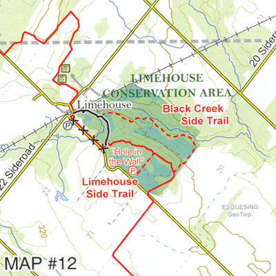
journey and retrieve any garbage that we have. She will meet us at
the 22.4km mark in the lower parking lot of the Limehouse School
off of 22nd Sideroad. If anyone has any other supplies that they
don't want to take along on the whole hike, you can give them to my
wife at the start of the hike as she will be dropping me off at the
starting location and watching us as we start our journey. You can
give her your stuff or retrieve anything that you dropped off to
her when she meets up with us later in the day. You could also
stash some supplied at a certain locations of your choice along the
trail so that you don't have to carry everything with you.
My
wonderful wife has kindly volunteered to meet us somewhere
along the route and bring us a fresh supply of water for our
journey and retrieve any garbage that we have. She will meet us at
the 22.4km mark in the lower parking lot of the Limehouse School
off of 22nd Sideroad. If anyone has any other supplies that they
don't want to take along on the whole hike, you can give them to my
wife at the start of the hike as she will be dropping me off at the
starting location and watching us as we start our journey. You can
give her your stuff or retrieve anything that you dropped off to
her when she meets up with us later in the day. You could also
stash some supplied at a certain locations of your choice along the
trail so that you don't have to carry everything with you.
 What your
should bring : Water and other drinks. Food for lunch,
dinner and snacks. GPS. Maps. Camera. Cell Phone. First Aid
Kit.
What your
should bring : Water and other drinks. Food for lunch,
dinner and snacks. GPS. Maps. Camera. Cell Phone. First Aid
Kit.
 Badges:
Those of us that complete this hike will qualify for the Toronto
Club End To End badge for hiking the entire Toronto Section of the
Bruce Trail. For more information and to obtain a badge, see this
Toronto Club
Badges link.
Badges:
Those of us that complete this hike will qualify for the Toronto
Club End To End badge for hiking the entire Toronto Section of the
Bruce Trail. For more information and to obtain a badge, see this
Toronto Club
Badges link.
 Geocaches:
There are 40 geocaches along the main trail of the Toronto section
of the Bruce Trail and many more very close by too. I have created
a list of the geocaches below which we will be hiking past. If I
have missed any, please let me know. It is your choice if you want
to stop and find any of these geocaches (I will probably stop to
find On the Way BACK from the BAT CAVE, as that is the only
geocache on the list that I have not found yet). Those who stop to
find geocaches can certainly catch up to the rest of the hikers. If
the whole group stops for every single geocache, it'll take too
long to complete the hike.
Geocaches:
There are 40 geocaches along the main trail of the Toronto section
of the Bruce Trail and many more very close by too. I have created
a list of the geocaches below which we will be hiking past. If I
have missed any, please let me know. It is your choice if you want
to stop and find any of these geocaches (I will probably stop to
find On the Way BACK from the BAT CAVE, as that is the only
geocache on the list that I have not found yet). Those who stop to
find geocaches can certainly catch up to the rest of the hikers. If
the whole group stops for every single geocache, it'll take too
long to complete the hike.
 Miscellaneous
Facts: We will be hiking about 10km more than the distance
of a marathon.
Miscellaneous
Facts: We will be hiking about 10km more than the distance
of a marathon.
The Toronto section of the Bruce Trail is now 3.8 km longer than
what it was in 1990.
|
List of people who
attended
(24 Total) |
res2100
psychocyclist
jeff-trex
TOMTEC
Timo Explorer
slaye
rovers3
owlnebula
d.e.b.s. (2x)
friends of d.e.b.s. (2x)
Miss T
Hunter and the Hownd
hikerT
Keith Watson
northernpenguin
GOTPPL
Muskoka Falls Sundogs
decor4 (2x)
Hunting_Hardies (2x)
Woodfella |
|
Geocaches along
the Route |
| Type |
ID |
Name |
Cache Placer |
Coordinates |
|
|
GCN268 |
Kelso 1000 |
dex4 |
N43 30.469 W79 57.388 |
|
|
GCRDC1 |
Hilton Falls Loop |
Nozzletime |
|
|
|
GCWEJ7 |
On the Way BACK from the BAT CAVE |
dex4 |
N43 31.370 W79 57.415 |
|
|
GCJ4BH |
On the Way to the Bat Cave |
dex4 |
N43 31.717 W79 57.398 |
|
|
GCG8PE |
The Bat Cave |
Dogs Breath |
N43 31.934 W79 57.348 |
|
|
GCMG9E |
Virtual GeoPoker Tour 2005 - Discard & Final Draw |
res2100 |
|
|
|
GCM6D4 |
Dave's Cave at the Crack |
Dave + Jen |
N43 32.729 W79 57.265 |
|
|
GCG3Y4 |
BT4: Where Did This Water Come From? |
res2100 |
N43 33.348 W79 57.555 |
|
|
GCVC58 |
Species 448788 |
1701eh |
|
|
|
GCHA0D |
Greystone Easy Cache |
dex4 |
N43 33.955 W79 57.642 |
|
|
GCYQ2P |
BFL Boot Camp – Dyslexia |
Keith Watson |
|
|
|
GCMNHR |
Bells, Whistles and a bit of Space |
The RidgeRunners |
|
|
|
GCG6H2 |
BT Final - 1: Enter My Lair |
res2100 |
|
|
|
GCVCDW |
Away Mission - Speyside |
1701eh |
|
|
|
GCKR8Y |
Halton Hills Cryptic: LONG |
charliezulu |
N43 36.606 W79 58.701 |
|
|
GCG3Y5 |
BT5: River Crossing |
res2100 |
N43 36.702 W79 58.653 |
|
|
GCVGZE |
Pioneer Double #4 |
The RidgeRunners |
|
|
|
GCVCDV |
Away Mission - Limehouse |
1701eh |
|
|
|
GCZ68E |
Trade DOWN |
res2100 |
N43 37.950 W79 58.118 |
|
|
GC4BD0 |
Ridgerunner's Cache of Many Trails |
The Ridgerunners |
|
|
|
GCJMVN |
The Gathering |
res2100 |
N43 38.047 W79 58.487 |
|
|
GCZ6EZ |
Where's Bouncy Bunny 2: Playing in Grassy Fields |
res2100 |
|
|
|
GC6650 |
Ridgerunner's Cache of Many Pins |
The Ridgerunners |
|
|
|
GCJ4BB |
Georgetown Walkway Cache |
dex4 |
N43 39.110 W79 59.577 |
|
|
GCKR94 |
Halton Hills Cryptic: The Final Watch |
charliezulu |
|
|
|
GCT04X |
Ont. Amateur Radio Repeater Tour #1 - Halton |
northernpenguin |
N43 40.539 W79 59.430 |
|
|
GCVMC4 |
Pioneer Double #5 |
The Ridgerunners |
|
|
|
GCG0WC |
Ridgerunner’s Individual Multi-Cache – Red Bucket |
The Ridgerunners |
|
|
|
GCG6H3 |
BT Final - 2: Lost Road |
res2100 |
|
|
|
GCR6QH |
GEST 6: Plains Of Existence |
res2100 |
|
|
|
GCG7V2 |
BT Bonus: Fallbrook Trail |
res2100 |
|
|
|
GC11RJP |
Sleepy Hollow |
Hooligan14 |
N43 41.380 W79 57.991 |
|
|
GCEBD4 |
You Must have Rocks In Your Head |
res2100 |
N43 42.589 W79 57.967 |
|
|
GCM1DN |
20 Tonnes Falls |
res2100 |
N43 42.676 W79 57.663 |
|
|
GCM1DV |
Terra Cotta Badlands |
res2100 |
N43 42.735 W79 57.562 |
|
|
GCRZ9H |
Crazy Cat Cache: Crazy Cats Kill For Sudokus |
Tylor2100 |
|
|
|
GCRGAE |
Walking in a Winter Wonderland |
res2100 |
N43 43.841 W79 57.395 |
|
|
GCG09W |
BT1: 3 Bridges |
res2100 |
N43 44.144 W79 56.360 |
|
|
GCTZZF |
Some Disassembly Required |
charliezulu |
|
|
|
GCZZZ1 |
I just hiked 52.3km, did you? |
res2100 |
N43 45.840 W79 56.250 |