EARTHCACHE REQUIREMENTS
Each cacher must send his/her own answers BEFORE logging a find. Enjoy the journey (learning adventure) as well as the destination (smiley earned). Remember to take only pictures and leave only footprints. To get credit for this Earthcache, complete the following tasks:
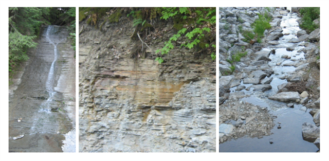
1. MESSAGE …. WATERFALL - Observe the shale layers that this 70' high cascade flows over. ... a. Describe the shale layers. ... b. What is the amount of falling water you see at the time of your visit? Use the magnitude of flow chart to answer this question.
2. MESSAGE …. OUTCROP - A short distance to your left is a shale bank. ... a. Describe the shale layers. ... b. What are the differences between both shale layers (waterfall and outcrop)? ... c. Explain (scientific or creative) why the shale is different even though only a few feet separate them.
3. MESSAGE …. CREEK - Look at the shale creek bed at the bottom of the falls. Now, cross the road and observe the creek bed there. ... a. What differences do you observe? ... b. Explain (scientific or creative) why the creek bed changes from one side of the road to the other.
NOTE: When we visited this site, I was surprised at the differences on both sides of the road. I opted for the creative explanation - There is a troll beneath the road that continuously quenches his thirst, thus reducing the amount of water from one side to the other.
4. LOG …. Post a picture at or near the coordinates. This picture is your log signature.
OPTIONAL - Please respect the time and effort involved in finding and creating this earthcache by adding A and B to your log.
A. JOURNEY OF THE MIND ... Science explains what we observe. Relate (in your own words) something you found interesting in the reading. This adds to your learning adventure and your log.
B. JOURNEY OF THE HEART ... Art shares our personal experience of what we see. Share something special you found on site, and why it is special to you. This is a memorable addition to your log and will make other hearts smile.
SHALE
Shale is a hardened, compacted clay or silty clay that commonly breaks along bedding planes. It can be fairly thick, or as thin as paper. Shales are easily eroded or worn away. When shales weather, they form clays or muds. The particle size is less than 1/256 mm.
The best exposures are found beneath ledges of harder more resistant rocks. Most shales are soft enough to be cut with a knife and can be very brittle. They are usually gray, but black, green, red or buff shales are also common. Shale and clay make up about 80% of the sedimentary rocks of the Earth's crust.
The Zoar Valley Gorge of Cattaraugus Creek cuts west for 7. 5 miles through up to 400 feet of Late Devonian shales and siltstones of the Canadaway Formation. This cascade is on a tributary to Waterman Creek which in turn is a tributary to Cattaraugus Creek. These shales extend throughout the Zoar Valley MUA and surrounding areas. Some shale cliffs appear to have relatively even layers, whereas others have eroded unevenly.
MAGNITUDE OF FLOW
1st Magnitude - 2800 L/s
2nd Magnitude - 280 to 2800 L/s
3rd Magnitude - 28 to 280 L/s
4th Magnitude - 6.3 to 28 L/s
5th Magnitude - 0.63 to 6.3 L/s
6th Magnitude - 63 to 630 mL/s
7th Magnitude - 8 to 63 mL/s
8th Magnitude - 8 mL/s
0 Magnitude - no flow (sites of past/historic flow)
RESOURCE
GEOLOGY OF THE ZOAR VALLEY GORGE OF CATTARAUGUS CREEK CATTARAUGUS AND ERIE COUNTIES, NEW YORK pdf