[JP]
笠山は、山口県萩市にある活火山であり、標高が 112mと火山として世界最小レベルです。
[EN]
Mt. Kasayama is an active volcano in Hagi city, Yamaguchi prefecture, whose size is the world's smallest level as a volcano with an altitude of 112 m.
[JP]
笠山は、日本でも数少ない単成火山群である阿武火山群に属する活火山であり(ただし、現在の笠山にはほとんど活動がみられていません)、玄武岩性の溶岩台地の上にスコリア丘が乗った形で形成されています(下写真( 萩ジオパーク構想推進協議会資料より引用))。公開座標が指す山頂には、直径30m、深さ30mの噴火口があります。
[EN]
Mt. Kasayama is an active volcano belonging to the Abu volcanic group which is one of rare monogenetic volcanic groups even in Japan (however, there is hardly any activity in the present Mt. Kasayama). The scoria hill is on the basaltic lava plateau (see the picture below cited from the material prepared by Hagi Geopark promotion committee) There is a crater with 30 m in diameter and 30 m in depth at the summit pointed by published coordinates.
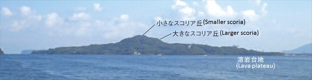
笠山の形成過程/Formation process of Mt. Kasamaya
[JP]
笠山は以下図(萩ジオパーク構想推進協議会資料より引用)のような過程で形成されました。
[EN]
Mt. Kasayama has been formed with the process shown in the figures below (cited from the material prepared by Hagi Geopark promotion committee).
[1]Large amount of lava flowed extensively and made lava plateau together with lava banks and lava robes.
[2]Small scale lava flowed far away, making lava banks.
[3]Aa lava flowed on a flat land, and some made lava banks and lava robes. Furthermore, a massive block lava was shed.
[4]A large amount of block lava flowed near the crater.
[5]From the eruption type of erupting the lava flow, it turned into a Stromboli type of eruption forming the scoria hills.
[6]Finally, a small Stromboli eruption occurred and a double scoria hill was created.
[7]The transgression began about 7000-5500 years ago, and Mt. Kasayama became an island.
[8.]The present Mt. Kasamaya has got connected to the land in the sandbar.


スコリア丘とは/What is "scoria hill"?
[JP]
スコリアは、マグマのしぶきからガスが抜けてできた穴の多い岩石です。公開座標の山頂部にある噴火口では、スコリアが積み重なったスコリア丘の内部が見られます。スコリア丘はスコリアが降り積もってできるので、噴火が終わると壊れて火口を埋め立ててしまいます。ところが、笠山では降り積もったスコリアの温度が高く、一部が溶けてお互いにくっついたために崩れにくく、噴火当時の様子が残っているのです。また、スコリアは普通、黒い色をしていますが、噴火したときに空気中の酸素と結びついた場合には、鉄さびと同じ赤色になります。
[EN]
Scoria is a rock with a lot of holes made out of gas from magma splash. At the crater at the summit of the published coordinates, you can see the inside of the scoria hill where scoria stacked up. Because the scoria hill is built up by the scoria, it breaks when the eruption is over and reclaims the crater. However, in Mt. Kasamaya, the temperature of the scoria accumulated there was high, part of the scoria melted and stuck to each other, so it is difficult to collapse, the situation at the time of the eruption remains. In addition, scoria usually has a black color, but if it is oxidized by oxygen in the air when erupted, it will be the same red color as the iron rust.
溶岩堤防とは/What is "lava bank"?
[JP]
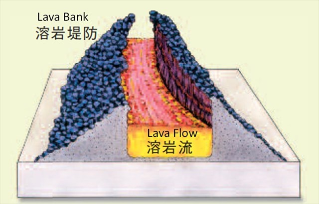
溶岩流の中央部は、次々と溶岩が供給されて力が加わり、また温度が高く維持されるために流れやすい一方、側面には力が加わらず冷えやすいために流れにくく先に固まり、川の堤防のように高くなります。 これを溶岩堤防と呼びます(下図参照。萩ジオパーク構想推進協議会資料より引用)
[EN]
Central part of lava flow is easy to flow because, since lava is supplied one after another, thus pushing force is applied and the temperature is maintained high. On the other hand, the sides of lava flow receives less pushing force, and they are easy to cool. Therefore, the sides of the lava flow are solidified earlier, then become higher as a river bank. This is called "lava bank." (See the figure below, cited from the material prepared by Hagi Geopark promotion committee.)
Task
[JP]
以下のクイズへの回答をキャッシュオーナに送ってください。(全ての回答はこのキャッシュの説明の中に見つけることが出来ます)
[EN]
Send your answers for the quizzes below to the cache owner.
Q1
[JP]
公開座標を訪れて、噴火口の内壁のスコリアを観察してください。このスコリアはどのような色をしていますか?また何故そのような色になったのでしょうか?
[EN]
Please visit the published coordinates and observe the scoria on the inner wall of the crater. What color is this scoria? Why did it become such a color?
Q2
[JP]
噴火口内にはスコリアの欠片が落ちています。1つ拾ってみましょう(持ち帰ってはいけません)。それは軽いですか?重いですか?また、何故そのような重さになったのでしょうか?
[EN]
Scoria fragments are on the ground in the crater. Let's pick up one (do not take it home!). Is it light? Is it heavy? Why did it become such a weight?
Q3
[JP]
噴火口の内壁のスコリアは、一見すると簡単にボロボロと崩れそうに見えます。実際に簡単に崩れるでしょうか?軽く触って確かめて見ましょう。崩れないとすると、何故そのようになったのでしょうか?
[EN]
The scoria on the inner wall of the crater seems to collapse easily and easily at first glance. Is it actually easy to collapse? Let's touch it lightly to see it. If it does not collapse, why did it become like that?
Q4
[JP]
Additional Waypoint "Q4"を訪れましょう(Additional Waypoint,"Parking for Q4"に車を停め、"Entrance for seashore"から海岸に下りることができます。足元に気をつけて!) ここでは、かつてここに溶岩が流れていた証拠を見つけることができます。その証拠とはなんでしょうか?
[EN]
Let's visit Additional Waypoint "Q4" (park your car at Additional Waypoint "Parking for Q4" and get off to the coast from "Entrance for seashore". Watch your step!) Here, you can find an evidence that the lava used to flow here. What is the evidence?