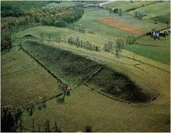
Titus Hill Drumlin
Submit your answers by E-Mail before logging your find.
Logs submitted without emailing an answer will be Deleted.
If you are doing this earth cache as a group, each person logging a find must submit their own answers to each earth cache question.
1. Why do you think Titus Hill is a drumlin?
2. What was the direction of the ice flow?
3. Why do you think the early settlers chose this hill for a cemetery rather than another flatter location. Remember, a glacier passed through here and they only had hand tools to dig a grave site.
4. Post a picture in your log with a personal item or hand in picture to prove you were there.
[REQUIRED] In accordance with the updated guidelines from Geocaching Headquarters published in June 2019, photos are now an acceptable logging requirement and WILL BE REQUIRED TO LOG THIS CACHE. Please provide a photo of yourself or a personal item in the picture to prove you visited the site.
TITUS HLL CEMETERY:
This posted coordinates for this earth cache will bring you to the oldest part of the Titus Hill Cemetery which is located on the Titus Hill drumlin. From the posted coordinates walk in the direction of the white farmhouse by the main road and check the slope of the hill. This farm house still belongs to the Titus family, who donated this land as a public cemetery. The cemetery has been in use since the 1800's. It is maintained entirely by volunteers, many from the original families who settled here.
For more information on the Titus Hill Cemetery follow this link - http://www.rubycusack.com/Titus-Hill.html
Now walk back towards the new stone gate by the road and check the slope of the hill from this point. Using the information from your walk, and the information given below, answer the 3 questions listed above and email us your answers.
ESKERS:
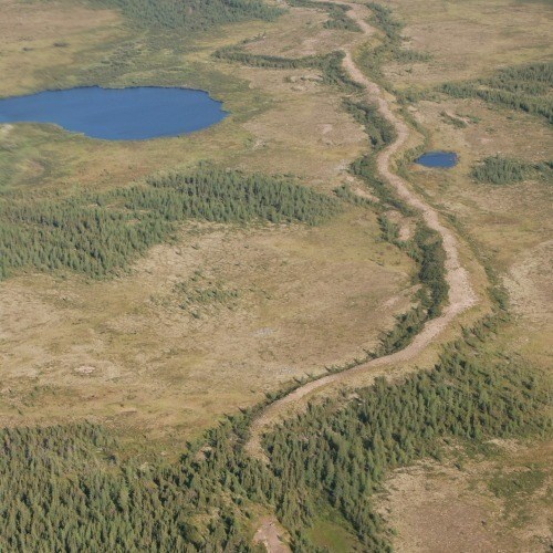
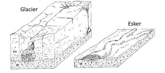
Eskers are ancient deposits made from sediment carrying water tunnels beneath or inside glacial ice fields. The floors of these channels can be rock, sediment, or even ice. As the water emerges from the tunnel at the end of an ice sheet or glacier it will slow down. Since the sediment movement depends on water currents, during retreat or during periods of low melt it drops the sediment it carries and builds small piles that take on the shape of the channels. When glaciers retreat the point of exit for the water will change with the moving edge of the glacier. The deposition will occur progressively further upstream leaving a narrow trail of sediment accumulation that takes on the shape of the channels.
In low-lying, boggy terrain these snaking ridges dominate the terrain, providing high points and many early roads were built on these dry route locations. Eskers are aligned parallel with the former ice flows.
KAMES:
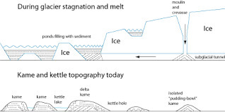
Kames (Scots - kaim a hill) are irregular hills of sand and gravel with steep slopes formed by material that has been transported by glacier melt water. The reasons for the mounds is that chunks of ice were buried containing material that was broken down by processes of weathering or erosion. When that ice melted a hill was formed. As with eskers the origin of the water and sediment is the same. They were left at the base of the glacier, resulting from settling out of the glacial melt water.
Kames are the most varied landforms resulting from deposition by glacial meltwater. A kame may occur as an isolated hill but more generally each kame is one mound in a low-lying terrain of many hummocks, terraces, ridges and hollows. Kames often occur in association with kettle holes in kame and kettle topography. Eskers may also occur between the kames.
DRUMLINS:
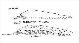
Drumlins (Irish - droimnín littlest ridge) are elongated land masses which form in the direction of ice flow, often a kilometer in length, a width of a few hundred meters and a height of tens of meters. They consist of whatever material is present beneath the ice. They are formed by erosion of existing material unlike eskers or kames, which are formed by deposition of material carried by ice flows. The most common material beneath glaciers is glacial sediment known as till. Drumlins are mostly filled with unconsolidated sediments that are poorly sorted, and may contain silts, sands, and gravel.
The classic drumlin shape is a hill that highest on its up-glacier end and tapers gently from there, like a half-buried egg. Because they have been streamlined by flowing ice, geologists often use them to understand past glacier flow directions. They are longest in the direction of flow.