La Source de l'Ozerain
L’Ozerain est un affluent de la Brenne, c'est-à-dire un sous-affluent de la Seine par l'Armançon et l'Yonne.
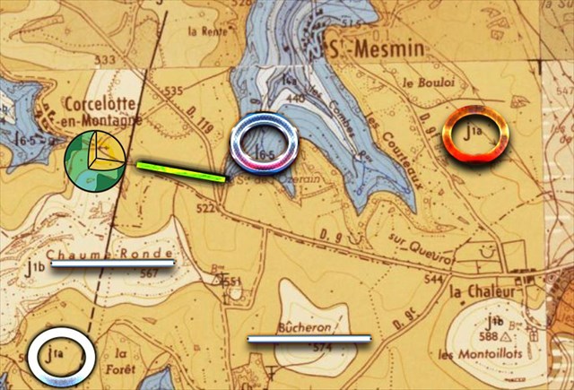
D'une longueur de 35,8 kilomètres, l'Ozerain prend sa source à moins de deux kilomètres des buttes Chaume Ronde (567 m) et Bûcheron (574 m), à l'altitude 504 mètres sur la commune de Saint-Mesmin.
Ce que nous apprend la notice
Il n'existe pas de cours d'eau importants dans le cadre de la feuille; cette région se situe au point de partage des eaux entre les bassins de la Seine, de la Loire et du Rhône.
Il existe plusieurs niveaux de sources (…) Enfin une dernière petite ligne de sources existe au niveau des marnes à Ostrea acuminata, au-dessous du calcaire hydraulique. Elle est très peu importante car son alimentation est limitée par la surface généralement exiguë des terrains sus-jacents.
Les terrains
J1b. Bajocien supérieur et base du Bathonien inférieur (30 m environ). Ces niveaux correspondent aux marnes à Ostrea acuminata surmontées de calcaires à grain fin, jaunes, appelés « calcaires
hydrauliques». Les marnes à Ostrea acuminata. Leur épaisseur est de 5 m environ. Dans ces marnes, les fossiles sont abondants; ils représentent beaucoup d'individus mais peu d'espèces.
J1a. Bajocien moyen et inférieur (30 à 40 m). Le Bajocien forme la falaise ou les escarpements calcaires qui s'observent au-dessus des marnes du Lias.
16-5. Aalénien et Toarcien (30 à 50 m environ). Au-dessus des derniers bancs du Domérien supérieur se développe une série marneuse de 30 à 50 m d'épaisseur.
EN
La Source de l'Ozerain
The Ozerain is a tributary of the Brenne, that is to say, a sub-tributary of the Seine by Armançon and Yonne.
With a length of 35.8 km1, the Ozerain rises less than two kilometers from the Buttes Chaume Ronde (567 m) and Bûcheron (574 m), at an altitude of 504 meters in the municipality of Saint-Mesmin.
What the record teaches us
There are no major rivers in the leaf; this region is located at the point of division of water between the basins of the Seine, the Loire and the Rhone.
There are several levels of sources (...) Finally a last small source line exists at the marl at Ostrea acuminata, below the hydraulic limestone. It is very small because its diet is limited by the generally small surface area of the overlying land.
The fields
J1b. Upper Bajocian and lower Bathonian base (about 30 m). These levels correspond to marls at Ostrea acuminata surmounted by fine-grained limestones, yellow, called "limestones
Hydraulic ". Marls in Ostrea acuminata. Their thickness is about 5 m. In these marls, fossils are abundant; they represent many individuals but few species.
J1a. Middle and lower Bajocian (30 to 40 m). The Bajocian forms the cliff or calcareous escarpments which are observed above the marls of the Lias.
16-5. Aalenian and Toarcian (30 to 50 m approximately). Above the last banks of the Upper Domérien develops a marly series of 30 to 50 m thick.
|
Source :
DESCRIPTION GÉOLOGIQUE DE L'AUXOIS P a r J.-J. COLLENOT
Infoterre.brgm.fr
|
Rappel concernant les « Earthcaches »: Il n'y a pas de conteneur à rechercher ni de logbook à renseigner. Il suffit de se rendre sur les lieux et d'éxécuter les requêtes du géocacheur.
Loguez cette cache "Found it" et envoyez-moi vos propositions de réponses soit via mon profil, soit via la messagerie geocaching.com (Message Center), EN PRECISANT LE NOM ET CODE GC DE LA CACHE et je vous contacterai en cas de problème.
Il est aussi apprécié d'avoir des photos des géocacheurs sur les lieux de l''EarthCache. Sentez-vous inspiré de poster des photos de vous lors de cette visite (optionnelle mais sympathique)
---
Reminder concerning "Earthcaches": there is neither a container to look for nor a logbook to sign.
Log in this cache " Found it " and send me your answers proposals or via my profile or via geocaching.com messaging (Message Center ) , BY PROVIDING THE NAME AND GC CODE OF THE CACHE and I will contact you in case of problems .
We also enjoy seeing photographs of people visiting this EarthCache. Please feel free to log photos of your visit...(this is entirely optional but funny)
Grâce à la lecture du descriptif et votre observation, répondez aux questions suivantes :
Thanks to the reading of the description and your observation, answer the following questions:
1 Quel élément géologique important se trouve non loin ?
2 Observez les premiers cm du sol, décrivez les et quels rôles jouent-ils?
3 Que va alimenter in fine les eaux de l’Ozerain
4 Que pouvez voir sous le spoiler ?
What important geological elements are nearby?
2 What holds water on the surface?
3 What will ultimately feed the waters of the Ozerain
4 What can you see under the spoiler?
Joyeux & happy EarthCache !