
本藏點的學習目標是深入認識河道蜿蜒現象。這種現象遍佈全國各地,規模大小不一。大型河道通常較少關注此現象,因其規模更貼近河流本體,而非溪流或小水道。河道蜿蜒現象指河流在覆蓋鬆散沉積物的緩坡地帶形成規律彎曲的曲線。當彎道弧度大於半圓時,則稱為蛇形彎道(蛇形彎)。透過考察地點並參照描述文字,您將能更深入觀察此現象,為後續解答問題奠定良好基礎。祝探索愉快!
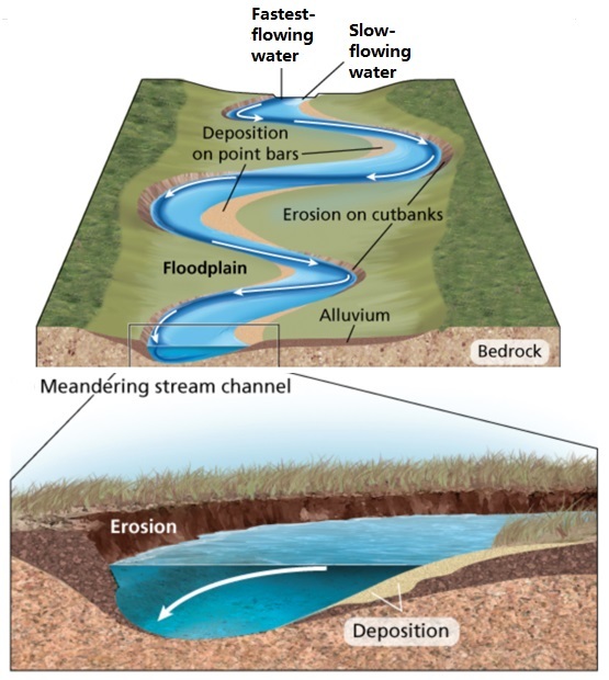
主要特徵:
蜿蜒河道用於根據其形態設計來區分特定類型的河流。支流可分為三種類型:交錯式、直線式與彎曲或蛇形式。在流經洪泛平原的河流中,當坡度較緩時,蜿蜒河道通常更易形成。
沉積物通常以鋸齒狀方式堆積於凸起處,隨後從該處向岸邊移動。在凹曲處則以侵蝕作用為主導,可清晰觀察到沉積物因離心力作用而退縮的現象。當凸曲處的沉積推進與凹曲處的退縮相互作用時,河道便開始遷移並形成蜿蜒曲折。
此類河流易於辨識或區別於其他類型,因其主要特徵在於河床中形成的極為清晰的蜿蜒曲線。
當蜿蜒水流形成極大彎曲時,可能導致河道變遷。此類河流在特定區域(如平原)持續移動,某個時期便可能形成所謂的河曲湖。每條河流的蜿蜒過程各不相同,因其取決於水流、流速及構成河道的物質特性。
蜿蜒曲折:
河水總是朝著一個方向流動,其流向由流經地形的坡度所決定,即使地表有時看似平坦。要驗證這點,可進行一個簡單實驗:將水注入管道,可見注水速度會隨管道坡度增減。
河床亦遵循相同原理。水流在河道中奔騰,地形越陡峭,水流速度越快,施加於地表的沖刷力便越強。正是這股力量侵蝕土地,使河道逐漸形成彎曲的形態。
當河川流經多孔滲透的表面時,自然水道的邊緣會持續遭受侵蝕。隨著侵蝕作用進行,河道逐漸形成特有的凹形曲線,從而構成彎曲形態。
地質學家指出,河道蜿蜒的形成過程可分為三個階段:腐蝕、侵蝕與磨蝕。首先,水流的高速沖刷力或水壓侵蝕河岸,攜走土壤、石塊與岩石。
這些被水流搬運的物質進而侵蝕河床。最終,顆粒間相互碰撞與分離,形成磨蝕作用,此過程增強了破壞河床基底的力量。
正如外側侵蝕形成彎道,沉積物也會在對岸堆積,形成彎道凸出或內側的弧面。河道彎曲現象通常發生於河流中下游,源頭處極少出現。這是因為河流在下游或中游區域,水流產生的壓力與力量最強大。河道蜿蜒不僅能改變地貌,甚至可能使河流改道。
要記錄此地球寶藏,
您必須親臨現場並回答與地球寶藏坐標相關的問題。
收集答案後,請將其提交給管理員進行核驗。
提交答案後即可立即記錄。若管理員對您的答案有疑問,將主動聯繫您。
未向管理員提交解答或存在待處理問題的記錄將被刪除,恕不另行通知。
請勿在記錄中附上可能透露問題答案的照片。
問題:
1. 請前往以下座標與WP點位進行實地考察後回答下列問題:
A. GZ與WP點:觀察河曲形態,記錄在河曲內彎處(GZ點)發現的礫石顆粒尺寸。A1) 您是否認為這些顆粒存在某種分級現象?B1) 最大顆粒尺寸為何?(若水位過高,可基於理論推論作答)
B. GZ與WP點:解釋礫石/石塊為何在此內彎處堆積?且大小顆粒為何分布於不同區域?
C. 若未來允許河道自由蜿蜒——經過足夠長時間後,此河曲將呈現何種形態?
2. 請於該地點拍攝個人、小組或GPS設備照片,且不得透露任何解答內容。
The learning purpose of this cache is to get to know meandering better. Meandering is clearly visible all over the country, in both large and small editions. The large editions tend not to think about this as the scope falls more in line with the size of the river, compared to a stream or a small os. The phenomenon of meanders are regular bends in rivers that run over very gently sloping ground covered with loose deposits. When the arc of the bends becomes larger than a semicircle, they are called serpentines (snake bends). You will have a closer look at this by studying the location and with the help of the text in the description, and you will have a good basis for answering the questions further down. Enjoy!
Main characteristics:
Meandering are used to characterize specific types of rivers based on their design. There are three types of tributaries: braided, straight and curved or serpentine. In the rivers that flow through the floodplain, meandering are usually easier to form when the slope is small.
The sediment is usually deposited in the bump in a zigzag fashion and then moves from there to the shore. In the recesses, erosion dominates, and it is clear how the filling retreats due to the centrifugal force. When the advance of the fill in the convex zone is combined with the retreat of the concave zone, the river course begins to migrate and meandering occur.
It is easy to identify or distinguish from other types of rivers, because its main characteristic is the very clear meandering curve it forms in the river bed.
When the meandering current forms a very large curve, it can cause the river course to change. They are constantly moving in certain areas, for example the plains, so they can form a so-called meander-shaped lake at a certain time. The meandering process of each river is different because it depends on the current, the speed of the water and the materials that make it up.
Meandering:
The water in a river always flows in one direction, which is determined by the slope of the terrain over which it moves, even if the surface sometimes appears flat. To test it, you can do a simple experiment. Put the water into the pipe, it can be seen that the water filling speed increases or decreases; the speed depends on the slope of the pipe.
The same applies to the river bed. The water flows in the channel; the steeper the terrain, the greater the speed of the water flow and therefore the greater the force on it. It is this force that erodes the land, causing the river channel to take on a curved shape.
As the river moves over the porous, permeable surface, the edges of the natural passage through which the river continues to flow are eroded. As it wears out, it takes on a characteristic concave shape, which creates a curve.
According to geologists, the meandering process occurs in three stages: corrosion, erosion and wear. First, the rapid force of the water or the pressure of the water corrodes the river bank and carries away soil, stones and rocks.
So this material moved by the force of the water helps to erode the river bed. Finally, the particles collide into the separated and colliding elements; this causes wear, which increases the force that destroys the foundations of the river bed.
In the same way that outward erosion forms a curve, sediment also accumulates on the opposite bank, forming the convex or inner side of the curve. Fluvial channels are usually formed in the middle and lower reaches of rivers; rarely occurs at the source. This is because it is in the lower or middle part of the river where the current produces the greatest pressure and force. Meandering can change the landscape and even change the course of the river.
To log this cache.
To get to log this cache you will have to visit and answer the questions which are related to the coordinates given the earthcache.
When answers are collected, send them to CO for verification.
You can log immediately after answers are sent CO. If there are any questions about your answers CO will contact you.
Logs without answers to CO or with pending questions from CO will be deleted without any further notice.
Please do not include pictures in your log that may answer the questions.
Questions:
1. Answer the questions below by visiting the coordinates and WP..
A. GZ and WP: Study the meander and note the size of the gravel/stone particles that you find in the inner bend of the meandering at gz. A1) Do you want to claim that the mass is sorted in some way? B1) How big are the largest gravel/stone particles? (If the water level is too high, you can answer based on theory.)
B. GZ and WP: Explain why the gravel/stone particles remain in the inside bend here? And why is it distributed with small and large particles in different places?
C. If the river is allowed to wander freely in the future - what will this meander look like after long enough time?
2. Take a photo of you, the group or the GPS from the location without revealing any of the answers.