Rappel concernant les « Earthcaches »
ATTENTION, il n'y a pas de conteneur à rechercher ni de logbook à renseigner. Il suffit de se rendre sur les lieux d'observations puis de réaliser les conditions de validation ci-dessous.
Une Earthcache ayant comme objectif de mettre en pratique une leçon de géologie par des observations de terrain, il est conseillé de lire le descriptif afin de vous aider à répondre aux questions.
Questions pour valider la cache géologique
!!! CACHE POUVANT ETRE INACCESSIBLE A MAREE HAUTE !!!
Avant de vous y aventurer, consulter l'horaire des marées sur l'île de Hoedic.
- Question 0 : Prenez une photo de vous ou votre pseudo avec un endroit que vous appréciez dans les environs (mais pas la zone d'observation).
Cette photo devra au choix nous être transmise avec les réponses ou être ajoutée à votre log.
Descendez sur la plage jusqu'à la photo WP1.
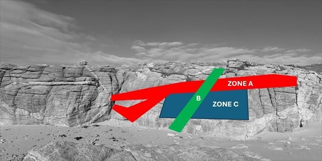
- Question 1 : Décrivez ce que vous voyez sous la zone A rouge et déduisez-en sa nature géologique.
- Question 2 : Pourquoi doit_on parler de faille et non de fracture pour la zone verte B ?
- Question 3 : Quelle type de faille occupe la zone B ? Justifiez votre réponse
- Question 4 : Déterminez le rejet de la faille de la zone B.
- Question 5 : Datez relativement les zones A rouge, B verte et C bleu en précisant quel principe de datation vous permet d'arriver à votre datation relative.
Vous pouvez vous loguer sans attendre notre confirmation,
mais vous devez nous envoyer les réponses en même temps soit par mail via notre profil (
fafahakkai), soit via la messagerie geocaching.com (Message Center).
S'il y a des problèmes avec vos réponses nous vous en ferons part.
Les logs enregistrés sans réponse seront supprimés.
Et en théorie, cela donne quoi ?
► Contexte géologique local
Le socle géologique d'Hoëdic est constitué de leucogranites de Bretagne méridionale formant une longue échine rocheuse soulignée par un chapelet d'îles dont fait partie Hoëdic.
A la Pointe des Châteaux, ce leucogranite présente une texture assez grossière (cristaux pluri-millimètriques) et est parcouru de larges filons de pegmatite.
La pegmatite est une roche intrusive cristalline quasiment blanche composée de phénocristaux (cristaux pluri-centimétriques) de minéraux silicatés comme le quartz et le feldspath plagioclase.
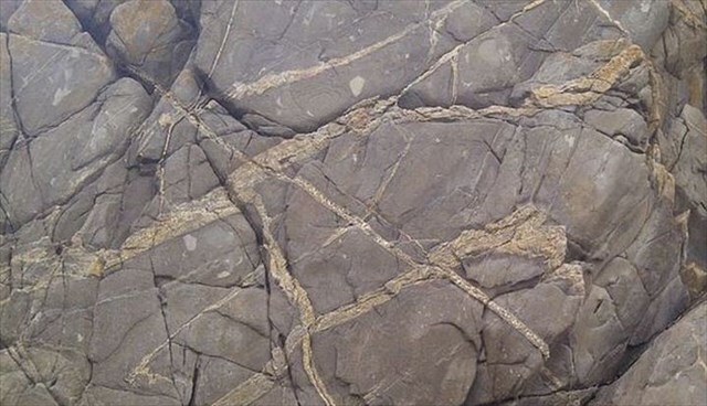
► Failles ou fractures ? Telle est la question
- Une fracture est une fissure simple, il n'y a pas de déplacement des compartiments de roche de part et d'autre de cette fissure.
- Une faille est une cassure, une rupture de la continuité de terrains primitivement situés au même niveau et qui s’accompagne d'un déplacement relatif des compartiments qu'elle détermine.
Les compartiments sont les blocs séparés par la faille, l'un étant « soulevé », l'autre « affaissé ».
► Types de failles
On définit trois principaux types de failles classées selon la direction du mouvement relatif :
- Faille normale : elle correspond à un mouvement d’extension entre les deux blocs et à l’effondrement vertical d’un bloc par rapport à un autre. Le plan de faille est incliné en descendant vers le bloc affaissé.
- Faille inverse : elle correspond à un mouvement de compression entre deux blocs avec un rejet vertical pour l’un des deux blocs. Le plan de faille surplombe le compartiment affaissé.
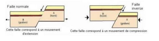
- Décrochement : Un décrochement accompagne un mouvement de coulissage horizontal et non vertical comme les deux autres types de faille.
► Le rejet de faille
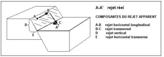
Le rejet de faille est un élément caractéristique d'une faille qui mesure la valeur du déplacement qui s’est produit entre les deux compartiments séparés par celle-ci.
Selon le type de déplacement (horizontal, vertical ou les deux), ce décalage peut avoir jusqu'à trois composantes orthogonales :
- si la faille est purement normale ou inverse, le rejet est vertical
- si la faille est purement décrochante, le rejet est horizontal
- si la faille est mixte, le rejet est transversal (valeur vectoriel de deux rejets, un vertical et un horizontal)
► La datation relative
La datation relative regroupe l'ensemble des méthodes de datation permettant d'ordonner chronologiquement des événements géologiques ou biologiques, les uns par rapport aux autres.
Cette reconstitution repose sur quatre principes issus de la stratigraphie.
- Le principe de superposition : ce principe ne s'applique qu'aux formations de dépôts stratifiés (sédimentaires ou volcaniques).
Il s'énonce ainsi : une couche de roches est plus récente que celle qu'elle recouvre et est plus ancienne que celle qui la recouvre.
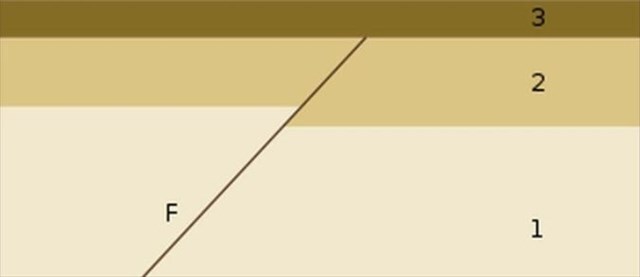
- Le principe de recoupement : Un événement (intrusion magmatique, faille, plissement, discordance, érosion) qui provoque un changement dans la géométrie des roches est postérieur à la dernière strate qu'il affecte et antérieur à la première strate non affectée.
Autrement dit, tout événement géologique qui en recoupe un autre lui est postérieur. Dans l’exemple ci-dessous, le filon F est postérieur aux strates 1 et 2, mais antérieure à la strate 3.
- Le principe de continuité : Bien que la base d'une strate soit plus âgée que son sommet, on considère qu'elle a le même âge sur toute son étendue même si sa composition change.
- Le principe d'inclusion : Les morceaux de roche inclus dans une autre couche sont plus anciens que leur contenant. Toute inclusion est plus ancienne que la structure qui l'entoure.
A reminder about Earthcaches
ATTENTION, there is no container to look for or logbook to fill in. All you have to do is go to the observation sites and complete the validation conditions below.
As the aim of a geology cache is to put a geology lesson into practice by making observations in the field, you are advised to read the description to help you answer the questions.
Questions to validate the geological cache
!!! HIDING PLACE MAY BE INACCESSIBLE AT HIGH TIDE !!!
Before venturing there, check the tide times on the island of Hoedic.
- Question 0 : Take a photo of yourself or your nickname with a place you like in the surrounding area (but not the observation area).
This photo can either be sent to us with your answers or added to your log.
Go down to the beach as far as photograph WP1.
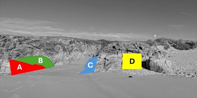
- Question 1 : Question 1: Describe what you see beneath the red area A and infer its geological nature.
- Question 2 : Why must we speak of a fault rather than a fracture for the green area B?
- Question 3 : What type of fault occupies area B? Justify your answer.
- Question 4 : Determine the displacement (throw) of the fault in area B.
- Question 5 : Establish the relative ages of the red area A, the green area B, and the blue area C, specifying which dating principle allows you to reach your relative dating.
You can log this cache without waiting for our confirmation,
but you must send us the answers at the same time, by e-mail via our profile (
fafahakkai) or by the system of Message Center of geocaching.com.
If there is a problem with your answers we will notify you.
The logs recorded without answers will be deleted.
What does this mean in theory?
► Local geological context
The geological basement of Hoëdic consists of leucogranites from southern Brittany, forming a long rocky ridge highlighted by a chain of islands, of which Hoëdic is part.
At Pointe des Châteaux, this leucogranite displays a fairly coarse texture (pluri-millimetric crystals) and is intersected by large pegmatite veins.
Pegmatite is a crystalline intrusive rock, almost white, composed of phenocrysts (pluri-centimetric crystals) of silicate minerals such as quartz and plagioclase feldspar.
► Faults or fractures? That is the question
A fracture is a simple crack; there is no displacement of the rock compartments on either side of the crack.
A fault is a break, a rupture in the continuity of rock layers that were originally at the same level, accompanied by a relative displacement of the compartments it defines.
The compartments are the blocks separated by the fault, one being “uplifted” and the other “downthrown.”
► Types of faults
Three main types of faults are defined according to the direction of relative movement:
- Normal fault: corresponds to extensional movement between two blocks and to the vertical subsidence of one block relative to the other. The fault plane dips toward the downthrown block.
- Reverse fault: corresponds to compressional movement between two blocks, with vertical displacement of one of the blocks. The fault plane overhangs the downthrown compartment.
- Strike-slip fault: involves horizontal sliding movement rather than vertical movement, unlike the two other types of faults.
► Fault displacement (throw)
Fault displacement (throw) is a characteristic of a fault that measures the magnitude of the movement that occurred between the two compartments separated by it.
Depending on the type of movement (horizontal, vertical, or both), this offset may have up to three orthogonal components:
- if the fault is purely normal or reverse, the displacement is vertical.
- if the fault is purely strike-slip, the displacement is horizontal.
- if the fault is mixed, the displacement is oblique (the vector value of two components: one vertical and one horizontal).
► Relative dating
Relative dating encompasses all dating methods that allow geological or biological events to be ordered chronologically with respect to one another.
This reconstruction is based on four principles derived from stratigraphy.
- Principle of superposition: this principle applies only to stratified deposits (sedimentary or volcanic). It states that a rock layer is younger than the one it overlies and older than the one that overlies it.
- Principle of cross-cutting relationships: an event (magmatic intrusion, faulting, folding, unconformity, erosion) that causes a change in the geometry of rocks is younger than the youngest layer it affects and older than the first layer that is not affected.
In other words, any geological event that cuts another is younger than the one it cuts. In the example below, dyke F is younger than layers 1 and 2, but older than layer 3.
- Principle of Continuity: Although the base of a stratum is older than its top, the stratum is considered to be of the same age throughout its entire extent, even if its composition varies.
- Principle of Inclusion: Fragments of rock included within another layer are older than the material that contains them. Any inclusion is older than the structure that surrounds it.
► Sources bibliographiques / Bibliographical sources