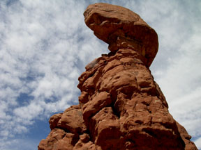
Balanced Rock
Directions:
Enter Arches NP from Highway 191 north of Moab. Follow the road
and signage to the turnout near the posted coordinates. It is a
short hike on a well marked path up a gentle grade to the base of
the feature.
Objectives:
- To understand how balanced rocks are formed;
- To be able to identify the Navajo and Entrada Formations within
Arches NP.
- To be able to describe “ice wedging” as an erosional
process.
Supplies: Water, camera. Access to a computer and Google.
Educational Requirement: To get
credit for this EarthCache you must email us your answer to any one
of the Study Questions and let us know how many people were in your
party.
Study Questions [Azimov-Rated]:
- College-Bound AP As you travel through the Park try to
identify rock formations that might someday become balanced rocks.
Post a picture of such a formation, along with its lat-lon
coordinates.
- College-Bound AP What differences do you see between the
Navajo and the Entrada formations?
- Freshman What differences do you see between the Slick
Rock and Dewey Bridge members of the Entrada Formation?
- Freshman What is the difference between mechanical
weathering and chemical weathering? What is “ice wedging”? Which
processes are operating here?
- Graduate What is a cap-rock? How are balanced rocks like
inverted valleys? Hint:
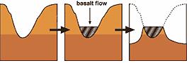
- Ph.D. How would carbonic acid accelerate the erosion of
sandstone? See Link Hint: What
“cements” the grains of sand?
Links and Resources:
Weathering
(Wikipedia)
More Weathering