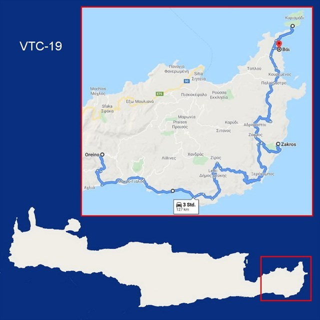
VTC-19: Virtual Trip to Crete (127 km)
Oreino – Zakros – Vai
***** Deutsch? - Bitte nach unten rollen! *****
***** Ελληνικά; - Προς τα κάτω, παρακαλώ! *****
This cache is part of the series „Virtual Trip to Crete“.
All information concerning the series here:
"VTC: Virtual Trip to Crete"
In time of Corona you may follow all the instructions of the listing virtually using Google Street View. This way no need to visit live all the tour stops to calculate the final's coordinates. Only for signing the logbook you should schedule a visit on Crete as soon as the Corona crisis is behind us.
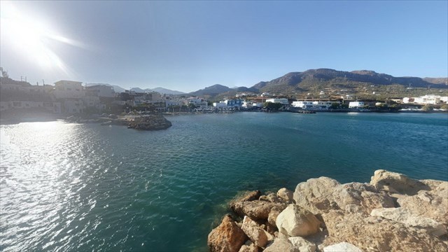
We now leave the mountains behind and drive back down to the sea. There is a geocache at waypoint A and from there we have a nice view to the village of Makry Gialos. You will find the picture you need for the determination of the final coordinates in the listing of the cache, since Google Street View has not been here.
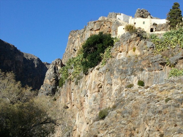
At waypoint B you look up to Kapsa Monastery. The monastery is described in detail in the listing of the geocache GC485GQ: Kapsa Monastery by wind&water. If you are coming in reality, do not miss to hike through the Perivolakia gorge, which runs north from here.
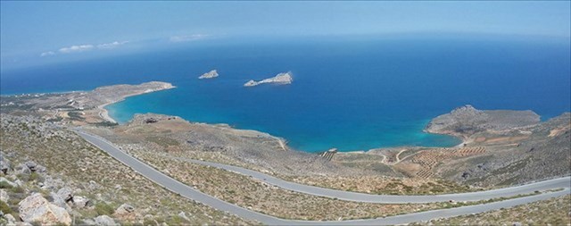
We continue to the easternmost beaches of Crete. At waypoint C we look over the serpentines of the country road down to the sea and the beach of Xerokampos.
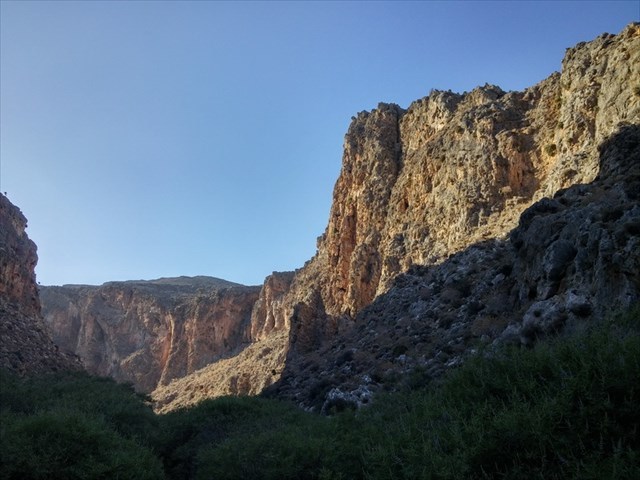
The Dead's Valley is next step. Ancient graves were carved into the steep cliffs of the valley. At waypoint D you can park your car and relax in a tavern after the hike.
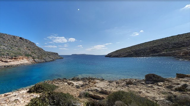
Going further on we pass Vai Palm Beach now to see it later, because we want to drive first to the northeastern tip of the island. At waypoint E, on Tentopoula Beach, the outermost geocache is hidden in that direction. The spoiler image of this cache helps you to determine the final coordinates, Google hasn't been here yet.
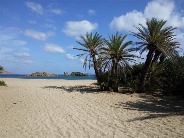
A few kilometers back and we end the stage on Vai Palm Beach. Virtually we will be here in solitude. In the season during the day, coaches regularly park in front of the beach, bringing loads of day guests to this beach. Of course, virtually we can also spend the night on the beach before we end our "Virtual Trip to Crete" with #20, the last section.
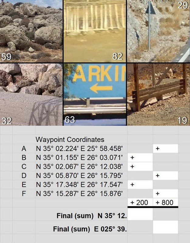
If you go virtually to these six waypoints and if you look around there, you will easily identify the following six pictures to calculate the final's coordinates:
Check your coordinates with certitude and get an additional spoiler picture:

… and now proceed on your „Virtual Trip to Crete“:
VTC-20: Vai – Sitia – Agios Nikolaos
Have a good virtual trip and see you soon on Crete!
***** Deutsch *****
Dieser Cache ist Teil der Serie „Virtual Trip to Crete“.
Alle Informationen zur Serie erfahrt ihr hier:
"VTC: Virtual Trip to Crete"
Allen Anweisungen dieses Listings könnt Ihr in Zeiten von Corona virtuell mit Google Street View folgen, so dass Ihr nicht tatsächlich vor Ort sein müsst, um die Finalkoordinaten zu berechnen. Nur das Signieren des Logbuchs müsst Ihr auf den Tag verschieben, an dem Ihr real nach Kreta reisen werdet.
Die Bilder im Text schaut Euch bitte in der englischen Beschreibung an!
Wir lassen jetzt die Berge hinter uns und fahren wieder hinunter ans Meer. Bei Wegepunkt A liegt ein Geocache und von dort haben wir einen schönen Blick auf den Urlaubsort Makry Gialos. Das Bild, das Ihr für die Bestimmung der Final-Koordinaten braucht, findet Ihr im Listing des Caches, da Google-Street-View hier nicht gefilmt hat.
Bei Wegepunkt B schaut Ihr hinauf zum Kloster Kapsa. Detailliert beschrieben ist das Kloster im Listing des Geocaches GC485GQ: Kapsa Monastery von wind&water. Versäumt nicht, wenn Ihr real hier sein werdet, auch durch die Schlucht Perivolakia zu wandern, die von hier aus nach Norden verläuft.
Weiter geht es zu den östlichsten Stränden Kretas. Bei Wegepunkt C schauen wir über die Serpentinen der Landstraße hinunter aufs Meer und den Ort Xerokampos.
Das Tal der Toten steht als Nächstes auf dem Programm. Der Name kommt daher, dass hier in die steilen Felswände des Tales antike Grabstätten gemeisselt wurden. Bei Wegepunkt D könnt Ihr Euer Auto abstellen und nach der Wanderung in einer Taverne entspannen.
Auf der Weiterfahrt lassen wir den Palmenstrand Vai zunächst rechts liegen, weil wir zuvor noch an den nordöstlichsten Zipfel der Insel fahren wollen. Bei Wegepunkt E, am Strand Tentopoula, ist der letzte Geocache in dieser Richtung versteckt. Das Spoilerbild dieses Caches hilft Euch bei der Bestimmung der Final-Koordinaten weiter. Google war jedenfalls noch nicht hier.
Ein paar Kilometer zurück und wir beenden die Etappe am Palmenstrand von Vai. Virtuell unterwegs sind wir hier allein. Tagsüber in der Saison parken vor dem Strand regelmäßig Reisebusse, die Urlauber zu einem Tagesausflug an diesen Strand bringen. Virtuell dürfen wir selbstverständlich auch am Strand übernachten, bevor wir mit der nächsten Etappe unser virtuelle Rundreise um Kreta beenden werden.
Wenn Ihr Euch an den sechs oben genannten Wegepunkten virtuell umschaut, werdet Ihr leicht sechs Bilder identifizieren können, die oben im englischen Listing bzw. in der Bildergalerie zu sehen sind. Dort findet Ihr auch das Rechenblatt das Euch zu den Finalkoordinaten führt.
Kontrolliert Eure Final-Koordinaten mit certitude und Ihr erhaltet ein zusätzliches Spoiler-Bild:
… und auf folgendem Streckenabschnitt könnt Ihr virtuell weiterreisen:
VTC-20: Vai – Sitia – Agios Nikolaos
Gute virtuelle Reise und bis bald wieder live auf Kreta!
***** Ελληνικά *****
Συνήθως η ελληνική έκδοση έρχεται πρώτη στις περιγραφές μου.
Αυτή η σειρά απευθύνεται κυρίως στους φίλους μας από το εξωτερικό.
Ως εκ τούτου, θα βρείτε την ελληνική έκδοση κατ 'εξαίρεση στο τέλος της λίστας.
Εντάξει;
Αυτό το geocache ανήκει στη σειρά „Virtual Trip to Crete“.
Όλες τις λεπτομέρειες της σειράς θα τις μάθετε εδώ:
"VTC: Virtual Trip to Crete"
Σε περιόδους Corona, μπορείτε να ακολουθήσετε όλες τις οδηγίες αυτής της περιγραφής με το Google Street View, έτσι μην χρειάζεται να είστε πραγματικά στην περιοχή για να υπολογίσετε τις συντεταγμένες του φινάλε. Απλώς πρέπει να αναβάλλετε την υπογραφή του ημερολογίου μέχρι την ημέρα που πραγματικά θα ταξιδέψετε στην Κρήτη.
Τις εικόνες για το κείμενο μπορείτε να τις βρείτε στην αγγλική περιγραφή!
Αφήνουμε τα βουνά πίσω και κατεβαίνουμε στη θάλασσα. Υπάρχει ένα geocache στο Σημείο Διαδρομής Α και από εκεί έχουμε ωραία θέα στο παραθεριστικό θέρετρο του Μακρύ Γιαλού. Μπορείτε να βρείτε την εικόνα που χρειάζεστε για τον υπολογισμό των συντεταγμένων του φινάλε στην περιγραφή του geocache, καθώς το Google Street View δεν ήρθε εδώ.
Στο Σημείο Διαδρομής Β βλέπετε τη Μονή Κάψα. Όλες τις λεπτομέρειες του μοναστηριού θα τις βρείτε στη περιγραφή του geocache GC485GQ: Μόνη Κάψα από τους wind&water. Αν θα είστε εδώ ζωντανά, μην χάσετε την πεζοπορία στο Φαράγγι Περιβολάκια, που πάει βόρεια από εδώ.
Συνεχίζουμε στις ανατολικότερες παραλίες της Κρήτης. Στο Σημείο Διαδρομής C βλέπουμε στις στροφές του δρόμου μέχρι τη θάλασσα και την παραλία του Ξερόκαμπου.
Το Φαράγγι των Νεκρών είναι ο επόμενος προορισμός μας. Αρχαίοι τάφοι ήταν λαξευμένοι στους απότομους βράχους του φαραγγιού. Στο Σημείο Διαδρομής D μπορείτε να παρκάρετε το αυτοκίνητό σας και να χαλαρώσετε σε μια ταβέρνα μετά την πεζοπορία.
Πρώτα θα αφήσουμε την παραλία του Βάι δεξιά, θα έρθουμε μετά. Τώρα θα πάμε στο βορειοανατολικό άκρο του νησιού. Στο Σημείο Διαδρομής Ε, στην παραλία της Τεντοπούλας, το τελευταίο geocache είναι κρυμμένο προς αυτή την κατεύθυνση. Η φωτογραφία spoiler αυτού του geocache σάς βοηθά να υπολογίσετε τις συντεταγμένες του φινάλε. Η Google δεν ήταν ακόμη εδώ.
Λίγα χιλιόμετρα πίσω και τελειώνουμε αυτό το τμήμα του ταξιδιού μας στο Φοινικόδασος του Βάι. «Εικονικά» είμαστε σχεδόν μόνοι εδώ. Στη σεζόν κατά τη διάρκεια της ημέρας, τα πούλμαν σταθμεύουν τακτικά μπροστά από την παραλία. Τότε έχει κόσμο, τουρίστες έρχονται για μια ημερήσια εκδρομή σε αυτήν την παραλία. «Εικονικά» μπορούμε επίσης να περάσουμε τη νύχτα στην παραλία πριν πάμε για το επόμενο, το τελευταίο τμήμα του «Virtual Trip to Crete»..
Ρίξτε μια εικονική ματιά στα έξι Σημεία Διαδρομής που προαναφέρθηκαν και θα μπορείτε εύκολα να εντοπίσετε τις έξι εικόνες που τις βλέπετε στην αγγλική λίστα παραπάνω ή στην γκαλερί εικόνων. Εκεί θα βρείτε επίσης το υπολογιστικό φύλλο που θα σας οδηγήσει στις συντεταγμένες του φινάλε.
Ελέγξτε την λύση σας με certitudeκαι θα πάρετε μια επιπλέον φωτογραφία «spoiler»:
… και συνεχίσετε το «Virtural Trip to Crete» με την παρακάτω τμήμα διαδρομής:
VTC-20: Vai – Sitia – Agios Nikolaos
Να έχετε ένα καλό εικονικό ταξίδι και θα σας δούμε ζωντανά σύντομα στην Κρήτη!