 Time Traveler
| Trackable Options |
 Found this item? Log in.
 |
 Printable information sheet to attach to Time Traveler
Print Info Sheet
Printable information sheet to attach to Time Traveler
Print Info Sheet |
| There are 4 users watching this listing. |
-
Owner:
-
Mountain Quest
Message this owner
-
Released:
-
Friday, February 21, 2003
-
Origin:
-
Utah, United States
-
Recently Spotted:
-
Unknown Location
The owner hasn't set their collectible preference.
Use TB4059 to reference this item.
First time logging a Trackable? Click here.
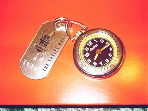
You have found the "Time Traveler" travel bug. Its goal is to visit as many different locations and time zones as possible. It is to be used as part of a fun navigation game that allows you to find your longitude without using your GPS.
Positions on the earth are described in terms of their latitude and longitude. This system dates back to the Greek philosophers who determined that the earth’s shape was spherical. Latitude (at least in the northern hemisphere) is simply a measurement of the angle between the horizon and the North Star (i.e. the angle would be 0 degrees at the equator and 90 degrees at the north pole). It describes where we lie with respect to the equator that divides the earth in northern and southern hemispheres. Northern latitude is by definition positive, with locations south of the equator described by negative angles. You can determine latitude using a protractor, a string, and a small fishing weight.
Lines of longitude pass through both poles and divide the earth into pieces similar to the sections of an orange. By the 18th century it was established that the reference longitude (0 degree longitude) would be a line that passed through the royal observatory at Greenwich England. This line is referred to as the prime meridian. Positive longitude is measured east from this reference as 0 to +180 degrees, and west from Greenwich as 0 to –180 degrees.
Developing an easy method to determine longitude was a difficult problem that baffled even the minds of great scientists like Galileo and Newton. The most straightforward method was simply to compare local time to the time back home (at Greenwich England). For this method to work, however, a very precise but portable timepiece was needed. The technology for such a timepiece did not exist at the time and many felt that it would be impossible to develop an instrument with sufficient accuracy. English clockmaker John Harrison accepted the challenge and eventually developed the required instrument (it took him 40 years to do so).
You will note that the time displayed on the “Time Traveler” is odd. This is because the time was set to reflect the local solar time at the place where this travel bug was created (approximately 41 degrees north, 112 degrees west [-112 degrees]). The displayed time is the time at the Greenwich observatory (commonly called Universal Coordinated Time or Greenwich Mean Time [GMT]) minus 7.46666 hours (7 hours 28 minutes). In other words when the “Time Traveler” displays 12:00 the sun with be at zenith over the “Time Traveler’s" home.
To determine your longitude using the “Time Traveler”, you simply record the time displayed on the watch when the sun reaches its zenith at your location. (One way to determine local noon is to draw a line on the ground toward true [not magnetic] north. Place a vertical stick in the ground at the south end of the line and record when the sun’s shadow crosses the line). Once you have recorded the time as displayed by the “Time Traveler” at local noon you can determine how far away you are from the “Time Traveler’s" home base using a simple procedure.
In a single rotation around its axis the Earth moves through 360 degrees and/or 24 hours. This means the earth rotates at a rate of 15 degrees per hour, or a degree every 4 minutes. To determine your longitude take the difference between the time you observed on the “Time Traveler” at local noon and 12:00. Convert this time difference (measured in hours and minutes) to total minutes (i.e. multiply the number of hours by 60 and add the residual minutes). Divide the derived number of minutes by 4 to determine degrees of longitude. If you are located east of the western U.S. the time recorded will be prior to 12:00. In this case add the number of degrees calculated to –112 (the result should be a number that is less negative than –112). If you are located on the west coast of the U.S. or further west, the time displayed on the “Time Traveler” will be past 12:00. To determine longitude in this situation, subtract the calculated number of degrees from -112 (should be a more negative number, like -120). Your answer should be your longitude (remember west longitude is defined to be negative). Note: if the “Time Traveler” ever becomes a world traveler and makes it into eastern Asia the time difference will exceed 12 hours, as the watch will have wrapped completely around. In this case add 12 hours to the calculated difference.
For example the “Time Traveler” was originally planted in a geocache near Norfolk Virginia. If this procedure were followed at that location the time appearing on the “Time Traveler” at local noon would be 9:36 a.m. This is 2 hours and 24 minutes prior to 12:00, or after conversion 144 minutes. Divide 144 minutes by 4 to get 36 degrees. To calculate our longitude we add 36 to –112 to get –76 degrees. A quick check of your GPS should confirm that Norfolk is at –76 degrees of longitude (or 76 degrees west).
Gallery Images related to Time Traveler
View All 2 Gallery Images
Tracking History (12370.3mi) View Map